Upping The Snow Totals, Intensity Of The Storm
BOSTON (CBS) - Our first widespread snow event including Boston and points south since February of 2011!
Sure we have had some mini snow events between then and now, but we certainly haven't had a snow map with 6-12" on it covering such a wide area of Eastern Massachusetts.
CHECK: Current Conditions | Interactive Radar | Watches & Warnings | WBZ Weather Blogs | Traffic
As 6-12" snowfalls go, this will be fairly manageable. While driving conditions will certainly be treacherous tonight, for the most part, this will be a light and fluffy, easily movable snow.
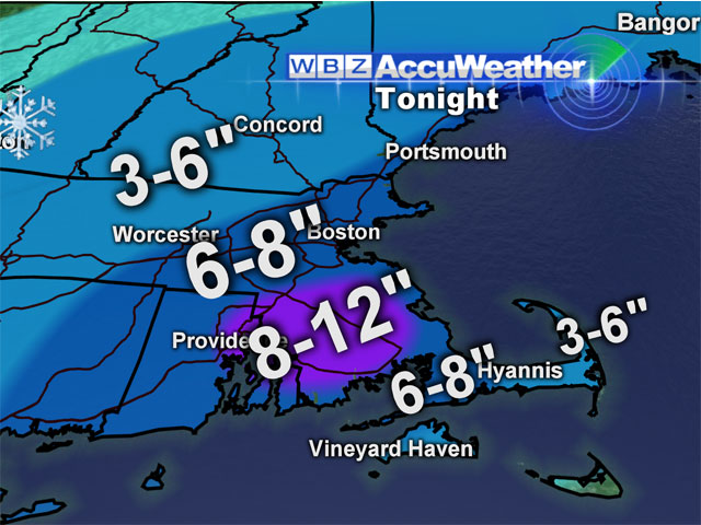
Here is the breakdown:
TIMELINE:
Light snow has already begun over most of Southern New England and this will become steadier and heavier over the next few hours. The snowfall will be most intense between 7 p.m. and 1 a.m. tonight. There will be bands of very intense snowfall (1-2" per hour) rotating in from the center of the storm off our southeast coastline during this time. The most intense snow will be over southeastern Massachusetts where some towns may pick up as much as 10" in just 6 hours. The snow will taper off to snow showers and flurries after 1 a.m. and be all over by sunrise Sunday.
PRECIPITATION TYPE:
This will be all snow for 90% of our forecast area. The exception will be along the South Coast and South Shore including the Cape and Islands. Ocean water temperatures are in the 40s, therefore 20-40 mph winds off the water will mix rain in with the snow in extreme southern areas. The outer Cape and Islands will see mainly rain from the event with perhaps just a change back to snow as the storm system pulls away.
SNOW AMOUNTS:
Due to the closer proximity to the storm, inland southeastern Massachusetts is in for the jackpot snow total of 6-12". Boston and the Mass Pike should be right on the 6" line and all areas north and west are expected to receive 3-6". Again, due to the mixing at the South Shore and South Coast, amounts will be lower -- likely 3-6" ... and 1-3" out on Cape Cod.
WIND/COASTAL CONCERNS:
Thankfully this storm will not cause any major wind or coastal issues. Winds will be gusty along the southeast coastline and over Cape Cod -- 20-40 mph gusts -- nothing near as powerful as the post-Christmas storm.
We will be watching the high tide just after midnight but tides have been lowering since that storm a few days ago, so no major flooding is expected.
This is going to be an intense 6-8 hour burst of snow tonight. If you dont need to travel you should stay off the roads. The snowfall will reduce visiblities to near zero at times. Plenty of time to shovel or crank up the snow blower on Sunday, it will be cold and windy but the accumulation will be long over.