Brace Yourselves: This Storm Means Business
BOSTON (CBS) - The bright morning sunshine will yield to some streamers of feathery clouds by midday and that high cloudiness will increase during the afternoon.
Temperatures starting out in the upper teens to middle 20s this morning will max out in the lower to middle 30s this afternoon as the north-northeasterly wind freshens to 8-16 mph.
CHECK: Interactive Radar | Watches & Warnings | WBZ Weather Blogs | Traffic | Closings
So all is calm and all is bright this morning but don't let that fool you. It's time to prepare for a major storm that will impact the region tonight into much of tomorrow. It may indeed be the last storm of 2012.
Here are the main bullet points:
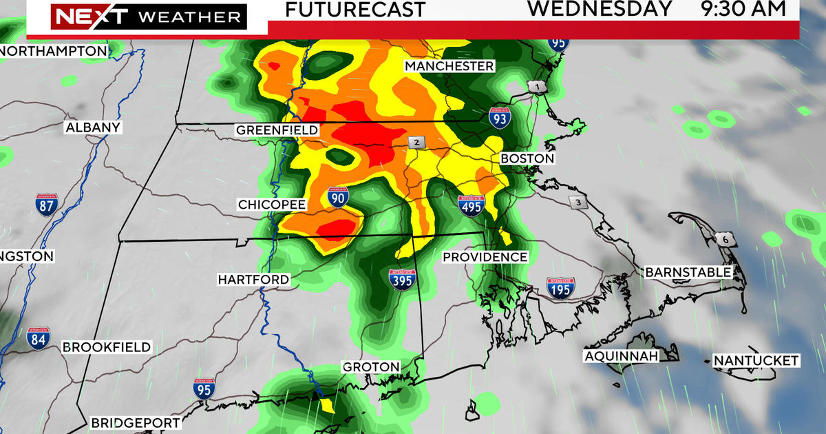
Expect heavy snow and a layer of ice across northern Middlesex County and northern Worcester County west and north and heavy rain of 1.5 to 2.5 inches over much of southern New England south of the snow and ice zone. This will cause poor drainage street flooding.
With east to northeasterly winds ramping up to 25-55 mph or so, there is a risk of scattered wind damage and power outages late tonight into tomorrow.
Seas will become rough and some minor flooding is possible near the high tide of 10:20 a.m. on Thursday. Splashover may result in some shore road closures.
With all of this in mind, get the shovels and plows ready in areas farther and farther north and west of Boston.
Check your vehicle's windshield washer fluid.
Be ready for potential power outages.
This storm means business.
It will be exiting the Tennessee Valley Wednesday morning and it will redevelop over VA through the afternoon on its trek toward New England with the center passing over Cape Cod early Thursday afternoon. The heaviest precipitation should occur in a 12-hour period from near 11 pm tonight to 11 am Thursday.
Potential snowfall will range from nothing over southeastern MA to a coating to an inch or so from outer Cape Ann to Boston to Providence up to 2-4" near the York County, ME coastline across the NH Seacoast to western Essex County through central Middlesex County to southern Worcester County to northern CT then up to 4-8" from interior southern ME to southeastern NH to northwestern Middlesex County and northern Worcester County building up to 8-12" from central ME to central NH to the Monadnock Region and perhaps into northwestern Worcester County to the northern Berkshires and finally more than a foot north of that. Adding complexity to this forecast is the high probability of a layer of sleet and freezing rain falling on top of the snow across northern MA into southern NH.
As the storm shifts across the Gulf of ME, the precipitation will taper off to showers through Thursday afternoon with a switch to snow showers from west to east later in the day. Clearing will ensue as the system moves over Nova Scotia Thursday night.
Consequently, the wind will become more northwesterly during the afternoon and decrease a bit but still be gusty right into Friday morning. At that time, the sunshine will be returning with just patches of passing clouds. Temperatures should max out in the upper 30s that afternoon.
Looking ahead, the storm threat for the weekend has decreased significantly. Guidance now suggests that an upper level trough of low pressure will not amplify quickly enough to steer the storm into New England. It will eventually intensify into a gale center but it should be located farther offshore. Some of its cloudiness may stream up over the area on Saturday with just a risk of flurries or a touch of light snow near the New England South Coast later that afternoon or evening. Glancing upstream, there is a mass of arctic air in much of Canada and it appears that it will be leaking into the Northeast late in the weekend and especially next week. A peak at First Night weather reveals that it will be partly cloudy with a slight risk of a passing flurry or snow squall as a cold front moves through the region. As we ring in 2013, temperatures will be falling into the upper to middle teens accompanied by a brisk cold wind. Despite ample sunshine, it might not exceed the upper teens to near 20 degrees on New Year's Day!
Check in for updates on the storm later today and I will be delivering the latest information early tomorrow.