Saturday Snow Storm To Bring Dangerous Blizzard Conditions
BOSTON (CBS) - Our storm has emerged over the open Atlantic and has started undergoing "bombogenesis," a very rapid intensification process. This will be a quick hitting but potent winter storm, featuring intense Blizzard conditions, some of the most vicious we will see in any winter season in Southern New England.
Read: Updated Blog From Terry Eliasen
Snow will become steadier and heavier with each hour and will really start to crank and accumulate after sunset. The most significant snowfall will occur In Eastern Massachusetts, most notably right along the Coastline between 6 p.m. and 1 a.m.
CHECK: Closings | Interactive Radar | Current Conditions | Share Photos | Weather Blog
Snowfall rates will reach 2-4" per hour! At the same time, the winds will be absolutely howling out of the North/Northeast. Expect 40-50 mph in Boston and 60-70 mph in extreme southeastern Massachusetts and over Cape Cod. This wind/snow combination will lead to an absolute whiteout with near zero visibility. There may also be significant wind damage with some downed trees and power outages in the blizzard warned areas.
I cannot stress enough -- please do not underestimate this storm. If you do not need to travel tonight, stay home!
As quickly as this one arrives it will zoom out of here. The snow will taper off and shut down after 1 a.m. with just a few lingering flurries on the Outer Cape. Think of this like winter-time thunderstorm for our East Coast, not long-lasting, but real nasty while it is here. In fact, I would not be surprised to hear reports of thunder-snow.
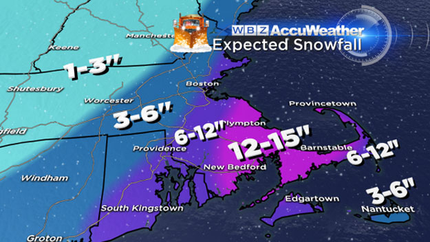
Final snow amounts in the jackpot zone in southeastern Mass.: 12-18" with some spot higher amounts likely.
Over Cape Cod expect 6-12" due to rain early in the storm. The Cape will not change to all snow until somewhere between 7-9 p.m.
In Boston, inside 128 and up through the North Shore, you can expect 6-12" of heavy wet snow.
The wildcard (or one of them anyways) with this storm will be what happens north and west of 128. There may not be much snow at all north and west of Boston in parts of Middlesex County and Worcester County. There will be a very sharp cutoff from about 3-6" between 128 and 495 to only 1-3" north and west of 495.
Again, for coastal residents, those in southeastern Massachusetts and over Cape Cod, this is a very dangerous storm. Do not get caught outside or on the roads when the blizzard begins, it could absolutely be a life threatening situation.
Stay tuned for storm updates throughout Tonight and stay safe!