South Shore, Upper Cape Hit Snow Jackpot
BOSTON (CBS) - Saturday night, snow was pouring down in southeastern Massachusetts. 1-3" per hour was being reported from Plymouth down through Sandwich. This will be the "jackpot area" for this event.
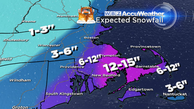
We now expect 12-15" of snow in extreme southeastern Massachusetts and for most the upper Cape. There may even be a few spot totals just a touch higher. Over the Outer Cape, they got off to a slow start and mixed with rain early on, so 6-12" will do it there.
North of Plymouth along the South Shore and into interior parts of Norfolk County, 6-12" expected.
CHECK: Closings | Interactive Radar | Current Conditions | Share Photos | Weather Blog
For Boston and nearby suburbs, including the 128 to 495 belt and North Shore, 3-6"…this area just missing out on the heavier snow bands to the south.
CHECK: Snow Totals
On the NW parts of 495 (Haverhill-Lawrence-Methuen-Lowell-Marlboro) expect right around 3", same goes for northern Worcester County and Southern New Hampshire.
Another major component to this storm…the winds…should not be ignored and actually several thousand power outages have already been reported in southeast Massachusetts. Gusts from 25-50mph will be frequent with a few higher gusts (50-65) over the Outer Cape and Nantucket.
Storm is long gone by the time you wake up Sunday morning. Winds will still be gusty so snow blowing will be a challenge, but nothing falling from the sky.
Still looks cold to start next week with the likelihood of some snow on Tuesday, although not expecting a major storm. And, milder days are ahead…40s, perhaps 50 degrees to finish the week!
MORE LOCAL NEWS FROM CBS BOSTON


