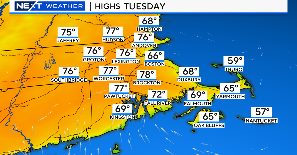
The Snow Storm Is Rolling In, And It'll Pack A Punch
BOSTON (CBS) - Our first winter storm is upon us across eastern Mass.
A Winter Storm Warning is in effect until 7 a.m. Sunday. The good news is that much of the afternoon will be fairly quiet, so if you have any last minute errands you should be fine. There will be light snow gradually developing this afternoon which could lead to some minor accumulations to a coating to an 1". Any light snow could quickly make it slippery especially inland, where temperatures will struggle to climb above freezing. Along the coast, with an east to northeast wind, temps should be able to warm into the mid-upper 30's. So any precipitation that falls will likely be in the form of light rain or sprinkles at the coast.
CHECK: Current Conditions | Interactive Radar | Watches & Warnings | WBZ Weather Blogs | Traffic
At Noon, the primary low we are tracking, is just pushing off the coast of Virginia. As the track moves closer toward New England late today, rain and snow will become steady by sunset.
The snow/ rain line will begin to collapse towards the coast for the evening hours as the storm deepens off the coast. Latest information is showing this storm will be a bit stronger and closer to the coast than we were thinking yesterday. In fact, some of our models show "Bombing" off the coast just before it pulls away, which will provide enhanced lift and dynamic amounts of precipitation in a short amount of time.
A coastal front will be in place right along the coast at this time. This boundary between the milder ocean air and the colder air inland will be the trigger for intense banding of snow fall which will be developing across eastern MA for the evening hours.
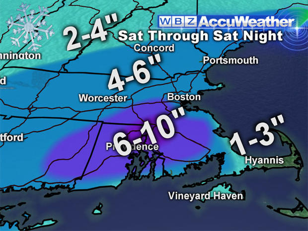
The peak of the snow will fall between 7 p.m. Saturday and 2 a.m. Sunday. The heaviest bands will likely be across Souteastern Mass. tonight, where 1-2" per hour of snow -- and even thundersnow -- may occur! It will be close to whiteout and blizzard conditions for a time right before this low begins to pull away and heads up to the Canadian maritime as a more mature and stronger storm.
We will have to watch this closely tonight. Depending where these bands set up, there is the potential for up to a foot of snow. Along the Pike and northwest of Boston, the precipitation will not be as heavy nor as intense, but it will be a fluffier snow. That could mean a deposit 4-8" of snow across most of the Commonwealth.
The coast remains a tough call because of it's proximity to the warmer ocean, which has a tendency to suppress higher snow accumulations. But this may be one of the exceptions if this storm strengthens enough.
Winds will be picking up from the northeast for Cape Cod, and will gust over 40 mph. We do not expect the kind of damaging wind or coastal flood threat that we had in the the last storm. Outside of 495 into Southern New Hampshire, amounts will be dropping off to about 3-6" of snowfall by the time this winds down during the early morning hours Sunday.
Travelling on the roadways should be avoided tonight if possible, as conditions will quickly deteriorate and roads will become snow covered. Sunday morning could be quite icy as temperatures will be dropping behind the front with strong northwest winds for Sunday. Stay tuned to WBZ-TV, WBZ NewsRadio 1030, and CBSBoston.com for updates through out the storm!