Four'Easter: Another Snowstorm Expected To Hit New England
BOSTON (CBS) -- New England can be a lovely place. Doesn't typically get too hot in the summer, you can't find a prettier landscape in the fall and Boston is a world class, amazing city.
Even with all that beauty, still, there are times like these where I find myself uttering the same phrase over and over under my breath. . . "what am I doing here?" Why do we put ourselves through the torture of New England winters year after year? Now, of course, if you are a skier/lover of snow, this certainly doesn't apply to you. In fact, I couldn't be happier for the New England ski areas who are reaping the rewards after some tough seasons as of late. But if you are just a plain ol' daily commuter, shoveler of snow, lover of the outdoors when it is green and lush. . . you, like me, have likely been asking yourself one simple question - why?
I had the same thoughts just 3 years ago as I was on my roof hacking at ice dams the size of a small pond. . . but then, eventually, you forget. Spring arrives as it does every year (although typically much later here than the rest of the country) and you move on. And that is exactly what we will do this year, again, eventually. . . just not yet.
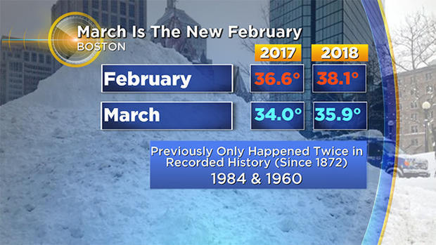
You may have heard the news, but just in case you missed it, allow me to ruin your day for you. A fourth nor'easter is coming, or as Eric Fisher is calling it, a Four'easter. In just 3 weeks of March we are now going on our 4th major storm. In case there was any doubt, March is ABSOLUTELY the new February. And we weren't exactly looking for a replacement.
In case you wondering what the deal is, why this is happening. . . is it climate change. . . is it the End of Days, I wrote an article last week which still applies.
Same pattern, same result, cold and snow. . . again.
So what do we have to look forward to this go-around? Here are some early thoughts…
Timing:
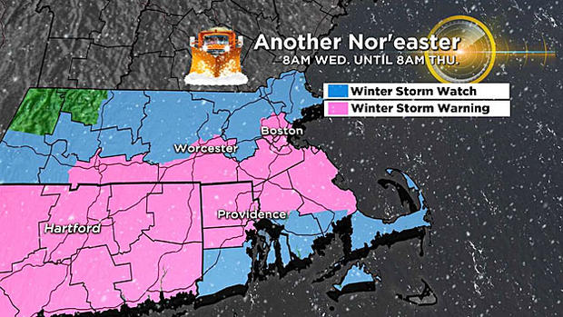
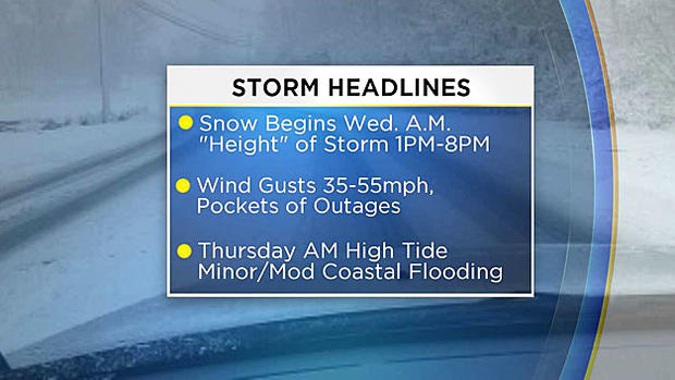
Main impact from this storm will be Wednesday PM through early Thursday.
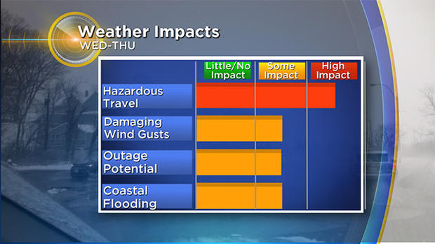
First flakes may arrive during Wednesday morning, but we don't expect anything very meaningful until late afternoon.
Wednesday AM commute will be fine, wind and snow will be picking up by the PM commute, worst travel occurs overnight. I would also plan on delays and slippery conditions for Thursday mornings commute as the storm wraps up.
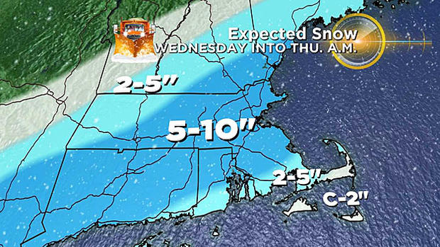
Snowfall:
Another widespread, plowable snow accumulation is expected. The highest amounts are likely to be in a strip right through central and eastern Mass. including Worcester and Boston.
Looking for a bit of good news? It doesn't appear that there will be any significant banding during this event. If you remember correctly, the highest, most outrageous snow totals from the last few events occurred under some very heavy snow bands. Doesn't look like this storm will have the same "juice" and power of the last few. So by that measure, we are not expecting totals nearly as high as last week.
Forecast:
5-10" A wide swath including all of Essex County, Middlesex County, Worcester County, Suffolk County and Norfolk County. Also the northern half of Bristol and Plymouth counties and most of southeast New Hampshire.
2-5" Southern Bristol and Plymouth counties to the Cape Cod Canal and areas in Western Mass. and far southwestern N.H. Some rain may mix in, snow will be very heavy and wet.
C-2" Cape Cod and the Islands, lots of rain mixing in here.
This will largely be a heavy, wet snowfall (as most spring storms are). Snow will be a tad "lighter" farther north and west (Worcester County and points westward).
Wind:
Another significant wind event, especially for our coastline.
Wind gusts will likely top out between 40-55 mph along the immediate coastline.
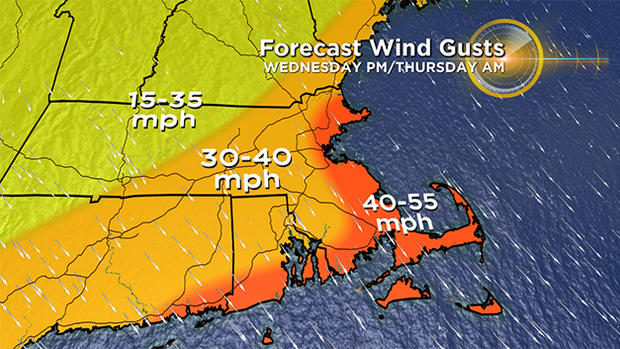
Just inland, expect gusts 30-40 mph.
We have certainly seen worse, but this will be just enough for another round of tree and wire damage, and sadly more power outages.
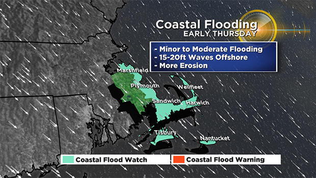
Coastline:
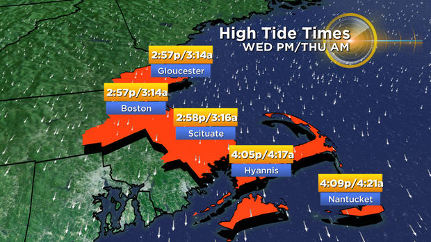
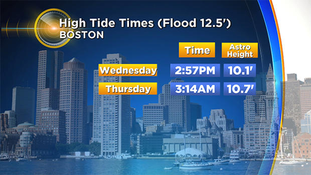
And here we go again, another round of coastal flooding and erosion. Tides are higher astronomically than last week (but thankfully not as high as the March 2 storm). Two high tides of concern (minor to pockets of moderate flooding) would be Wednesday afternoon between 2-4 p.m. and Thursday morning between 3-5 a.m. Wave heights will be 10-20 feet just offshore and storm surge likely between 1-3 ft.
Is This The End?
I wish I could declare this the grand finale. But alas, I cannot. This storm will not be a "pattern buster" - expect the colder than average, stormy times to continue. Our next "chance" of a storm comes Saturday night and Sunday. Right now it looks like that one MAY slide far enough south to mainly be a miss here. . .but then again, so did this one initially, and the one before that. . .
Follow Terry on Twitter @TerryWBZ