Why So Many Nor'Easters In A Row?
BOSTON (CBS) - What the *$%& is going on? Is this unusual? Is this global warming? When will it end?
That's just a sampling of the many questions and frustrations we have heard over the last several days, and that's the PG-edited version.
Memories are flooding back from our last similar stretch of weather back in 2015 - the anger, sense of utter defeat, the hopelessness of a never-ending winter barrage, and that was 3 short years ago. It is all too soon. At least back in 2015 it occurred in January and February. Dealing with this in March, so close (but so far) from spring, just doesn't seem right. This is a real low blow from Mother Nature.
First off, let me reassure you, the world is not ending. This is not some apocalyptic, Game of Thrones ("Winter is coming"), end of times. The Earth is still moving on its axis and spring and summer will still arrive on schedule.
Is this unusual? Yes and no.
Three nor'easters in 11 days is, of course, not typical for any time of the year. But is has happened before, several times, and it will happen again. We were in a similar pattern back in the winters of 2015, 2010, 1996 and the list goes on.
Now, you could make the argument that our biggest storms have become "more severe" and more frequent in recent years, perhaps due to the changing climate. This is a topic requiring a lot more space than just this little blog, however, I would say that there are some signs that are seemingly unmistakable in making this connection. My typical response would be that it is awfully hard to connect one storm or even three storms to changes that are going on at a global level.
However, there are a few "hints" that might point to something bigger going on. First and foremost, the coastal flooding.
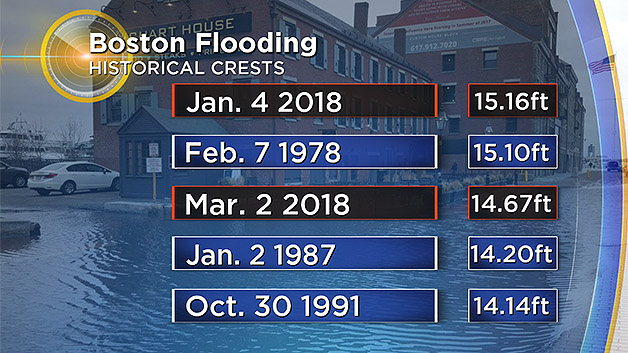
We broke the record from 1978 in Boston for the highest ever recorded tide reading in Boston back in January. And then we proceeded to nearly break it again on March 2 (we ended up third all-time). The sea level is rising, in some places faster than others, and it so happens that in Boston and points along the East Coast, we are seeing some of the most rapid rises. This is having an effect on our coastal flooding not just during storms but also during astronomically high tide cycles when the weather is quiet. And if you have beachfront property, I don't have to tell you that our coastline is being reshaped. In fact, some of you that didn't have beachfront property just a few years (or few weeks) ago, now suddenly have a terrific ocean view!
I also wonder about things such as thundersnow, just another weather buzz-word to most folks, but to meteorologists it is much more than that. It sure seems like not that long ago, hearing thunder or seeing lightning in a snowstorm in the Northeast was an epic, once in a lifetime event (see Jim Cantore freaking out on YouTube).
It was like spotting a double rainbow or a unicorn prancing around in the wild. Now, it seems, thundersnow occurs in just about every snowstorm. Perhaps a sign that our most powerful storms are happening with a much greater frequency than they once were. Many would argue that we just have better technology now, a better ability to find and detect these sorts of phenomenon. This is also possible. A great debate though!
Okay, back to our current situation. So while it may not be unprecedented, it certainly has been a wild first two weeks of March. So what is causing this? Our atmosphere is an insanely complex place and to blame our weather on just one variable would be silly. BUT there is one thing that we can point to that is present now and is a staple for some of the stormiest and snowiest periods in New England recorded history.
What is it? No, it isn't the groundhog seeing his shadow, good guess though.
It is something we call the NAO, North Atlantic Oscillation. We have had a strong and persistent negative NAO for the last few weeks, which essentially means there is high pressure sitting over or near Greenland. When this atmospheric setup occurs, it is commonly referred to as the "Greenland Block."
You get a big ridge in the jetstream over Greenland and while milder air is sent up that way, Canadian cold is re-routed south, making a bee-line straight for the Northeast U.S.
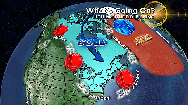
This also typically spurs an active storm pattern with several areas of low pressure pin-wheeling down from Canada. These storms then redevelop over the warm, Gulf Stream current off the U.S. East Coast and "bomb-out." With the block in place, the storms cannot track to our west, (bringing rain) but instead they are shunted eastward, off or Coast, and BANG, you get nor'easter city.
So, after three nor'easters in 11 days, we must be about done right? Sadly, no.
It is tough to break down these Greenland blocks, many times it takes several weeks. Currently, it appears that we will remain in this pattern for at least the next week, maybe two before we see any significant changes. That certainly doesn't guarantee more nor'easters but it means we should not let our guard down. In fact, there are several signs pointing towards a fourth nor'easter around Tuesday/Wednesday of next week.

It's too early to determine hit or miss, but given the current pattern, I would say the odds are not on our side. In short, I wouldn't put the snow shovels and snow blowers away just yet. Technically spring is only 6 days away!
Of course, that is also about the time of our next potential storm. Just think, when those milder spring days finally do arrive, how much more appreciative we will be.
Follow Terry on Twitter @TerryWBZ