Saturday Storm Could Bring 8 Inches Of Snow
BOSTON (CBS) - It won't be a blockbuster storm by New England standards, but it WILL be the biggest event of the season thus far for many folks, especially north and west of Boston.
There are still some concerns, meteorologically speaking this is not a "slam dunk."
Watch Eric Fisher's latest forecast
The temperatures are going to be very marginal at multiple levels of the atmosphere, so a degree or two here or there could mean the difference of several inches of snow versus a mix and rain.
As has been the case with most of our storms so far this winter, there is no real significant source of cold air in place, no cold high pressure anchored in Canada. There is also an obvious lack of blocking in the northern Atlantic, nothing to stop this storm or even slow it down. It is going to literally accelerate past New England, in and out of here in about 12 hours.
Check: Weather Blog | Current Conditions | Share Photos
So the question is how much snow can we squeeze out of this storm as it zips by to our south on Saturday?
Let's break it down step by step.
TIMELINE
Chapter 1: Start Your Engines
4 a.m - 8 a.m.
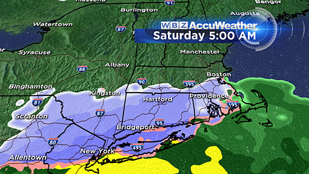
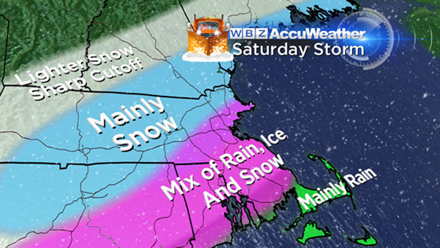
The time frame has moved up a bit. We now expect the precipitation to begin around 4 a.m. on the South Coast and to spread northward and encompass all of southern New England by 8 a.m. There will likely be a quick burst of snow on the front end of this storm, so nearly everyone will see snow at the start with the exception of the Cape and Islands. There could be a quick inch or two in the early to mid-morning hours just about everywhere including southeastern Massachusetts.
Chapter 2: The Warm Air Invasion
8 a.m. - 2 p.m.
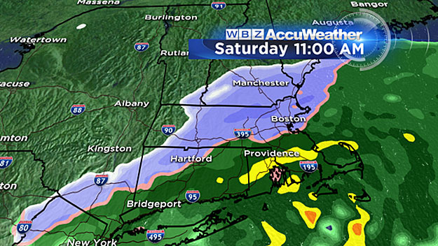
Warmer air moves in and the snow changes to sleet and rain, first along the South Coast and very quickly northward to about the Mass Pike. Both Boston and Worcester should be mixing with sleet and rain by late morning/midday. The mixing line could reach as far north as Route 2 around 1 p.m. Snow will continue north and west of I-495 and Route 2, but there will be a sharp cutoff on the far northern edge of the precipitation shield. Very little if any snow is likely to fall north of Manchester, New Hampshire and southern Vermont.
Chapter 3: The Snow Strikes Back
2 p.m. - 8 p.m.
Winds will begin to veer to a more north-northwest direction, drawing in colder air and changing any rain and mix over to all snow from north to south. At the same time, the back edge of the precipitation will start moving west to east.
Approximate end times:
Fitchburg and Worcester: 5 p.m.
MetroWest, 495/128: 6 p.m.
Boston and immediate coastline: 7 p.m.
South Shore: 8 p.m.
Cape Cod: 9 - 10 p.m.
ACCUMULATION:
Cape Cod and Islands:
Mainly rain, coating to an inch possible at the tail end.
South Shore, inland southeastern Mass.:
One-to-3 inches. A little at the beginning, then rain, then a little at the end. Mush.
Boston area:
Right around 3 inches, but it depends on how much warming we get and how long it sticks around. Very wet and sloppy. This would be the biggest snowfall in Boston in nearly a year.
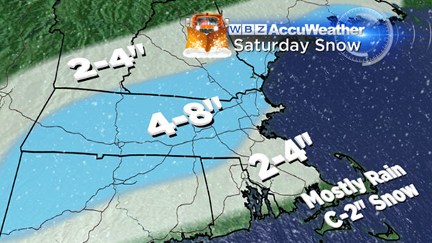
North and West, 128 to 495 to Route 2, including most of Essex, Middlesex and Worcester counties, southeast New Hampshire and southern (coastal) Maine:
Four-to-8 inches of snow.
Southern Vermont, central New England:
Two-to-4 inches of lighter precipitation, near the northern edge.
Northern Ski Areas:
Sadly not much here, just some flurries.
OTHER CONCERNS
Winds:
This system will be rapidly deepening and strengthening as it passes south of New England. Therefore, we do expect the winds to play a role along the coast and over Cape Cod and the Islands.
Gusts should reach between 30-to-50 mph Saturday night, strongest as the storm is passing by late. There could be some minor wind damage or isolated outages in these locations.
Again, since the strongest winds will be on the backside of the storm they would be out of the north/northwest, generally an offshore direction, other than in Cape Cod Bay.
Tides/Coastal Flooding:
Not a major concern with this storm due to the fast movement.
Some pockets of minor coastal flooding are possible during the Saturday afternoon high tide (around 2:30 p.m.). The winds will have turned mainly offshore by the following high tide (around 2:30 a.m. Sunday).
Follow Terry on Twitter @TerryWBZ


