Soaking Rain Takes Aim At Mass. On Sunday
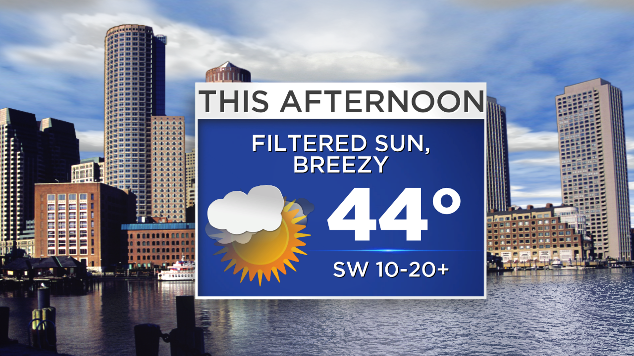
Today is certainly the pick of the weekend as rain is slated to move in by the afternoon tomorrow. Sunshine will be blotted and filtered by mid/high altitude clouds this afternoon and temperatures will rise into the low to mid 40s (approaching 50 on Cape Cod!). There will be an active southwest wind though, gusting occasionally to 25 mph. Tomorrow morning will be dry…but it all goes downhill after that.
Timing: Rain arrives during the early afternoon from south to north, falling heavily at times from 5-11 PM. In other words, bring the rain gear if you're headed to Gillette Stadium! The bulk of the precipitation will be done around or just after midnight. Most of what falls from the sky will be rain, but it may come down hard enough to mix down some colder air and cause the rain to mix with and change over to wet snow along and outside of 495.
Check: Current Conditions | Interactive Radar | WBZ Weather Blog
Rain Expected: In general, rain totals will be around or just over 1" for many communities. Expect large puddles, ponding of water on the roads and poor drainage flooding as the heavy rain comes through. Ofcourse you'll also have reduced visibility on the roads. Use caution.
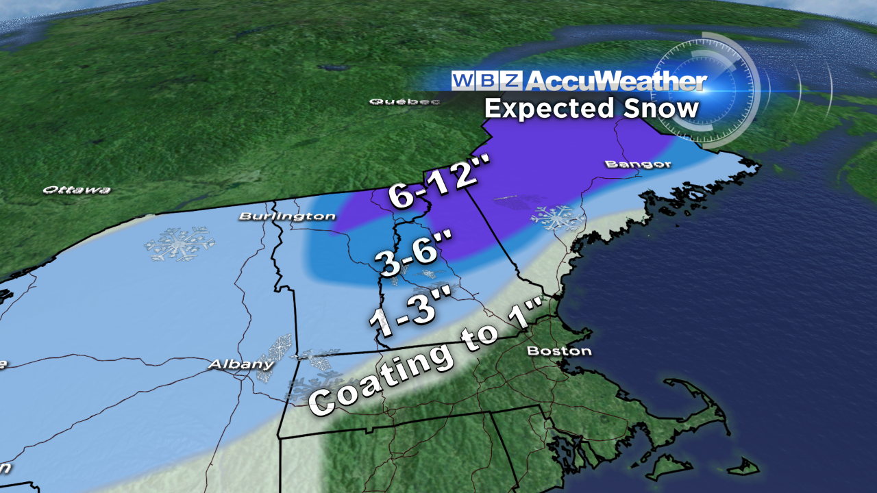
Snow Expected: A coating to 1" is possible along/outside of 495 with a sharp ramp up in totals as you head north into central Vermont, central NH & much of Maine away from the coast. 6-12" of snow is likely for a lot of Ski Country which is great news, but the snow will also hamper cleanup efforts in Maine where thousands are still without power from LAST weekend's ice storm. The wet consistency of the snow will mean new scattered outages in the central and northern part of the Pine Tree state. There is still a bit of time to tweak the accumulation map...if the storm center tracks a little farther NW, then everything on this map will shift that way as well. Conversely, if the storm tracks a bit farther SE, then I may need to tug the coating to 1" into central MA.
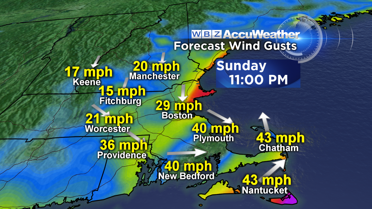
Wind: The wind will be gusty at the coastline, strongest between 9 PM and midnight. With the storm center expected to pass somewhere around the Cape Cod Canal, the wind direction will vary. For those on the Cape, it will come in from the east, then briefly southeast, turning southwest then northwest as the storm center goes by around midnight. Gusts should top out around 45 mph over southeast MA, although isolated gusts over 50 are possible on Cape Cod and the Islands. A few pockets of damage may occur.
And as I'm sure you've heard, the big story after this storm will be the arctic air! Monday will be our transition…a brisk wind and temperatures in the upper 30s (wind chills in the 20s). That will feel balmy compared to what's in store for the middle and end of next week. High temperatures won't get out of the teens and low 20s as we round out 2013 and ring in the New Year! So you have fair warning…it's going to be COLD for New Year's Eve festivities…warm clothes, layer & some hand and foot warmers perhaps? :)
I'll post another update tomorrow morning!
-Danielle