Plowable Snow Coming This Weekend
BOSTON (CBS) - Is this Christmas coming quick or what? It officially hit me last night when my son showed me his handmade calendar with the number 14 being scratched off - 13 days left!
I am sure most of you, like me, have lots of things on the "to do" list this weekend. Maybe you're a little late picking out your tree? Or perhaps you have a holiday party to attend?
Surely you aren't done with your Christmas shopping yet, right? Well, put one more thing on your weekend list - snow storm!
It is coming, but the good news is it will not be a major event.
Check: Current Conditions | Interactive Radar | WBZ Weather Blog
There will be no talk of a blizzard, no coastal flooding, no major power outages, just a nice scene setter for the holidays, albeit coming at sort of a busy time.
It will be our biggest snow event thus far, and I guess you could technically call it a Nor'easter, although I would hesitate to do so because that word tends to heighten the fear level in many people.
We will have some decent winds out of the northeast on Sunday morning along with the snow, so it does meet the criteria, but this will be far from a memorable snow storm.
As usual, I couch all that as I am about to say with this - we are still several days, many hours away from this storm. In fact, it has yet to actually form yet.
So, inevitably there will be some changes to this forecast, but here is our best shot as of now.
TIMELINE
Light snow may begin to fall as early as Saturday afternoon, but it will not be significant or really start to accumulate until well after dark. Most of the snow which will fall with this storm will occur at night.
It will still be snowing when you wake up Sunday morning, but most of the accumulation should be done by 9 or 10 a.m. and certainly by noon you will be free to start the cleanup.
PRECIPITATION
This will be a mainly snow event.
There is plenty of cold air in place for this storm, ensuring that everyone will start as snow. As the storm makes it closest pass Sunday morning, there will likely be some mixing with sleet and possibly with rain over Cape Cod and parts of southeastern Massachusetts. This mixing is also possible along the immediate coastline from Boston to Cape Ann, but it would be brief. The snow would be on the fluffy side for most, especially north and west of Boston, pretty easy stuff to move around.
SNOW AMOUNTS
Again, it is a bit early and this may change, but at this point I think 3-to-6 inches is a safe bet for Boston and nearby suburbs. There may be just a bit less along the South Coast and Cape due to mixing.
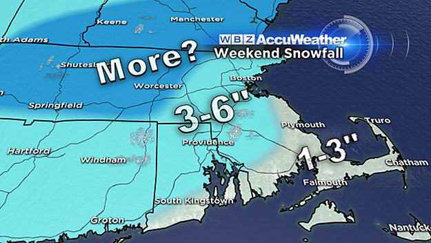
Where it is sure to stay all snow (north and west of Boston) and be a bit fluffier (therefore easier to accumulate) there could be a bit more than 6 inches, perhaps up to 8 or even 9 inches in spots.
WINDS-COASTAL ISSUES
No big worries here, I'm not concerned with coastal flooding. The winds will be a bit gusty out of the northeast on Sunday morning, perhaps 20-to-40 mph along the coast, nothing residents there haven't dealt with many times before.
So again, this storm will not be a big deal by our hardy New Englander standards.
Nonetheless, we would urge that you stay tuned to updated forecasts as some of the finer details are bound to change in the next 24-to-48 hours.
Follow Terry on Twitter @TerryWBZ
MORE LOCAL NEWS FROM CBS BOSTON