Holiday Storm Update
Find Eric Fisher on Twitter and Facebook
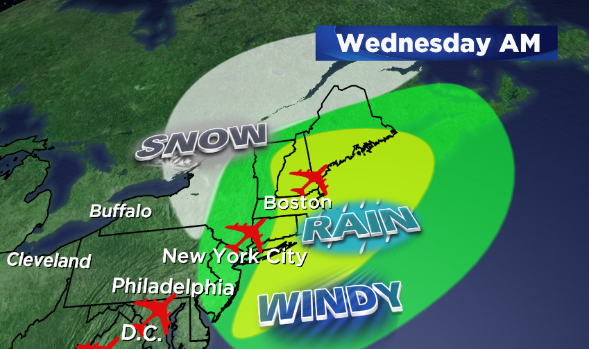
As our holiday storm moves in, no major changes to the forecast idea from last night. You can read that blog here. But the idea is that we'll get our biggest rain event since June, there will be localized flooding, and strong winds may bring down trees and power lines.
Travel issues for the next 36 hours…
First things first, a round of applause for the FAA. Even with rain and snow moving up the East Coast during very high volume times for travel, flight delays have been minimal. However, that's partly because many flights were preemptively canceled. Over 1,000 of them, in fact. So there are certainly travel headaches out there, and I think many of them will be felt on the roads with rain slowing people down in the I-95 corridor, and snowfall making driving treacherous across NYS, western PA, OH, and KY.
There is also some wintry concern here. As mentioned last night, the onset of the precipitation has included some snow, sleet, and freezing rain. A Freezing Rain Advisory is up for a small area of the state, as well as southwestern NH, through 2 AM (as of this writing). There will be pockets of icy travel there before the cold air gets scoured out and temperatures rise above freezing (I think this will happen for most locations by midnight).

New England Impact
This looks to be the wettest storm we've had here since all the way back in June! It's been such a dry fall that we should easily eclipse the total we've seen since the start of October (1.44″ in Boston). We're on track for 1-3" of total rainfall, which may lead to localized poor drainage and urban flooding. The ground is also frozen in areas, which means runoff will be an issue and not all of this will soak into the ground. A Flood Watch has been posted by the National Weather Service for the whole region.
Heaviest rain timing is about 1 AM through 2 PM, with scattered downpours and downright nasty travel conditions. If you can stay home on Wednesday morning, do it. The combo of rain and wind will not make things fun out there. But if you must drive, certainly expect to do it at a much slower pace.

Wind is another concern, and the strongest gusts are still expected to be across SE Mass, including Boston and the South Shore. The window will be fairly brief as an unusually strong low-level-jet will wash across the eastern edge of the state. These winds will be 90 knots just about 1-2,000' up! Downpours can help transfer some of that wind energy down, and the damage potential will be higher if temperatures manage to get up into the 60s (leads to steeper lapse rates). Even though the NWS High Wind Warning does *not* currently include Cape Cod & the Islands, I would not pay too much attention to that fact. I still expect very strong wind gusts there.
The final part of the story is late Wednesday into early Thanksgiving day. Once this storm passes, we'll be crashing from the low 60s to the upper 20s! That's a wild swing, and I'd suggest enjoying those few hours of truly mild air while it's here. The long-term outlook is pretty much for nothing but cold. Winter off to an early start!
As rain showers wrap up, snow showers should move in. The snow will be most likely across the Berkshires, southern Vermont, southern New Hampshire, and the Worcester Hills. Accumulation will probably be pretty light, but with rapidly falling temps we'll have to watch for a quick round of icing up where water and snow have gathered. So especially if your travel plans take you west on Wednesday evening, be very wary of potentially slippery roads. We'll have better timing ideas on this tomorrow.
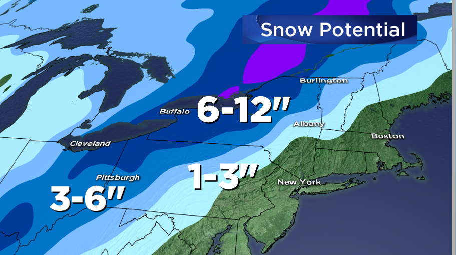
Speaking of traveling![]() west…if you or a loved one is making a trip to or from western NY and PA, they'll be dealing with the wintry side of this one. There will be enough cold air on the chilly side of the storm to produce a round of heavy, wet snow. Some areas could see up to a foot of new snow! These areas typically get most of their annual snow from lake-effect events, so its a bit unusual for them. Cities like Buffalo, Rochester, Cleveland, and Pittsburgh will be watching this one closely.
west…if you or a loved one is making a trip to or from western NY and PA, they'll be dealing with the wintry side of this one. There will be enough cold air on the chilly side of the storm to produce a round of heavy, wet snow. Some areas could see up to a foot of new snow! These areas typically get most of their annual snow from lake-effect events, so its a bit unusual for them. Cities like Buffalo, Rochester, Cleveland, and Pittsburgh will be watching this one closely.
Thanksgiving…Frozen Turkeys!
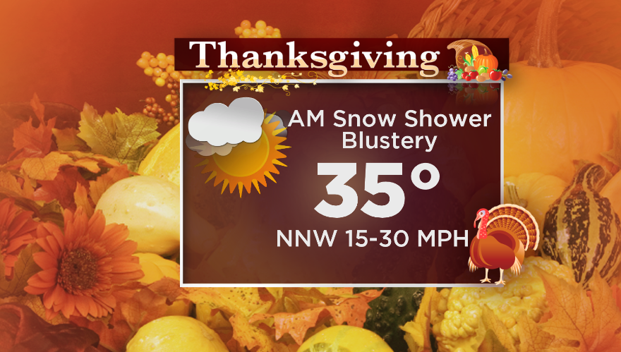
Some towns, again mainly hills, will wake up to a shallow blanket of white on Thanksgiving morning. And regardless of whether you get snow or not on the tail end of this storm, it will be a very chilly Thanksgiving this year. Bundle up for the backyard football game or 5k, with highs in the low 30s and plenty of gusty northwest winds! May be a little difficult for the balloon handlers at the Macy's parade in NYC, too (must-see TV?).
The cold will linger through the upcoming weekend, with a shot for some light snow to move in on Sunday. Still a ways out and lots of hurdles to clear before we get there, but bottom line is to keep a stack of wood ready for the fireplace for the next 7 days.
