Storm Heads In As Many Head Out
Find Eric Fisher on Twitter and Facebook
Of course we're going to have a storm on one of the busiest days of the year for travel, after 4 months of nearly completely quiet conditions. Weather is nothing, if not ironic. And so Mother Nature will have a good chuckle this week as many try their best to travel their way across the Nation.
Travel issues for the next two days...
Let's start at where the storm is now. It's the same system that brought flooding rain to SoCal last week, and heavy snow to the 4 corners region of the southwest over the weekend. It's led to the cancellation of over 400 flights in Dallas, spin-outs on numerous highways, and icing even as far south as Alabama and Georgia. Well now it has tapped the moisture-rich resource of the Gulf of Mexico, which means the East Coast is in for a good old fashioned soaking over the next 48 hours.
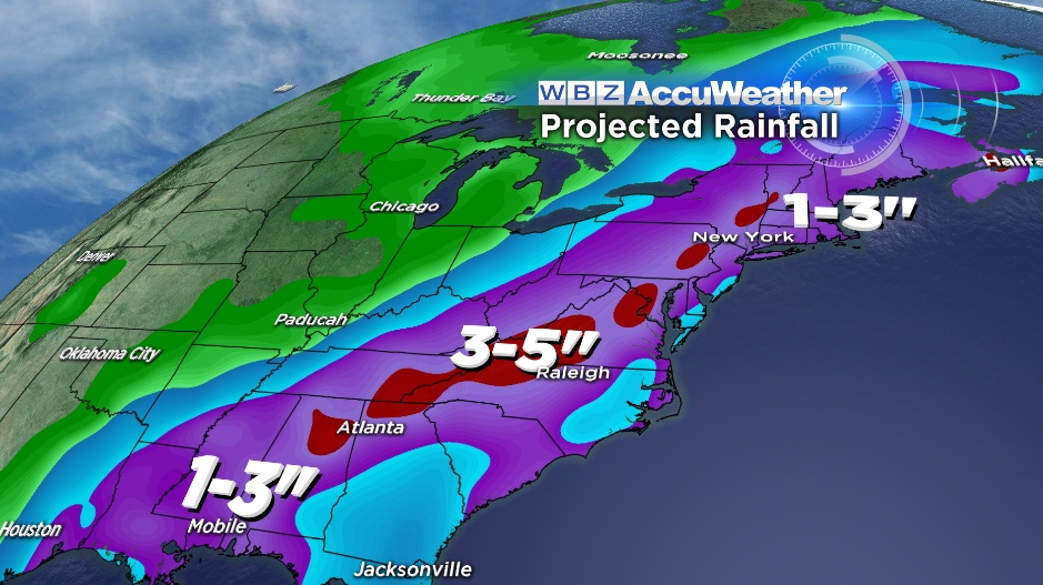
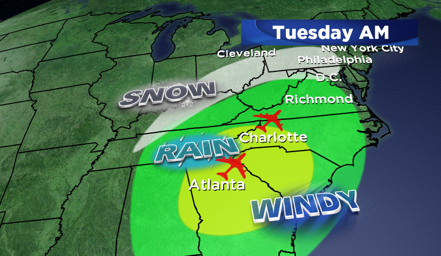
First up, the southeast. Tuesday morning will be especially frustrating at Hartsfield-Jackson Airport in Atlanta, which is the world's busiest airport. When you add in downpours, the delays stack up. And since it's a major connection airport, there will be a trickle-down effect. Charlotte will also be in the heavy rain bulls-eye during the morning.
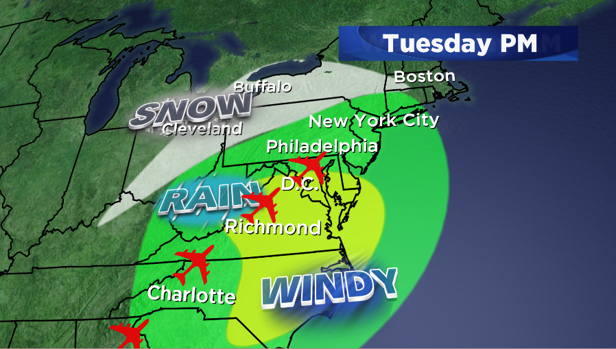
Then we move to the Mid-Atlantic. By the evening, very heavy rain will be rolling into places like Washington D.C., another big pair of airports for connections with DCA and IAD in the area. And the rain will fall for the last several hours of flights in and out of NYC. I can see the forlorn faces staring up at flight boards already.
New England Impact
If you're not heading through any of those areas or expecting guests from them, you're probably just asking 'okay, so how about New England'? Well this looks to be the wettest storm we've had here since all the way back in June! It's been such a dry fall that we should easily eclipse the total we've seen since the start of October (1.44" in Boston).
The leading edge of rain should be approaching us from the southwest between 6pm and 8pm. There's a chance that as this heads into the area, some wet snowflakes or areas of freezing rain could kick it off. This would be most likely across northern MA and southern NH/VT, and is a fairly slim shot, but something we will have to monitor before all the cold air gets kicked out. But the long and the short of it is that this is mainly a rain event, and any snow would be very short lived.
Why you ask? Well one thing this system is missing is a big area of high pressure just camping out over southeastern Canada. If there were a strong high in place there, it would help lock in the cold and we'd have a more typical Nor'Easter with much more snow in the forecast. But this time around, southeasterly winds will easily take over and wash away all the cold, plus there's nothing to slow this baby down. Great for two reasons. 1) No damaging snow event here and 2) The storm will be moving very quickly, limiting its impact.
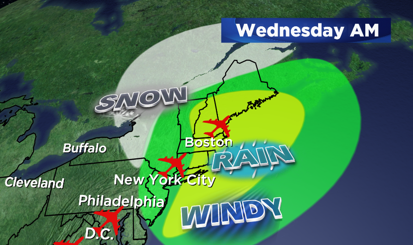
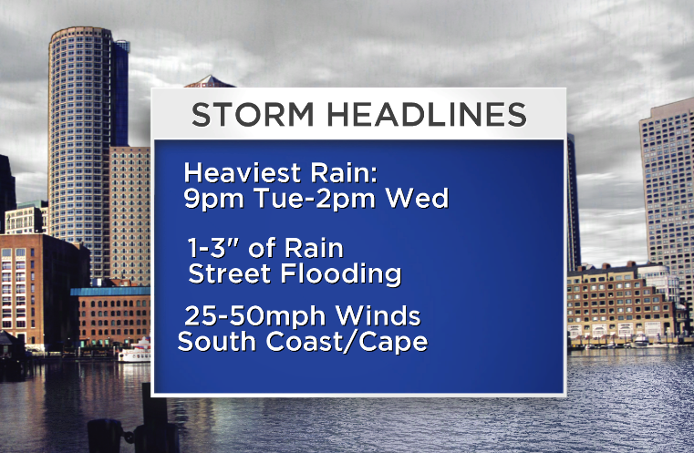
The heaviest rain comes down Tuesday night and early Wednesday - again pretty lucky for us since many will be sleeping during the worst of this event. A widespread 1-3" looks likely, which could cause some poor drainage street flooding during the heaviest downpours. Make sure to clear out gutters both on the streets and on your house on Tuesday before the rain moves in! I think Wednesday morning will look pretty ugly here locally, but once we get past midday the heaviest and most concentrated rain should be on its way off to the NE. Showers may remain, but the main show will be ending for afternoon/evening travelers.
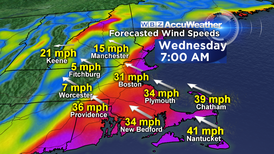
Not just rain, but wind!
Then we get to the wind side of this. The National Weather Service in Taunton has issued a High Wind Watch for late Tuesday night through Wednesday afternoon. They're calling for gusts that could potentially exceed 50mph. With the low tracking up close to the Hudson Valley, we should see the strongest winds out across far eastern parts of the state, particularly Cape Cod, the South Coast, and The Islands. Scattered power outages, downed limbs and wires, and some property damage will be possible during this time frame. Metro Boston will also be quite gusty, but likely falling just shy of a truly damaging wind event.
The final part of the story is late Wednesday into early Thanksgiving day. Once this storm passes, we'll be crashing from the low 60s to the upper 20s! That's a wild swing, and I'd suggest enjoying those few hours of truly mild air while it's here. The long-term outlook is pretty much for nothing but cold. Winter off to an early start!
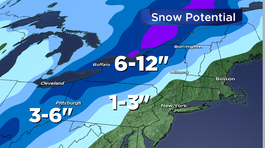
As rain showers wrap up, snow showers should move in. The snow will be most likely across the Berkshires, southern Vermont, southern New Hampshire, and the Worcester Hills. Accumulation will probably be pretty light, but with rapidly falling temps we'll have to watch for a quick round of icing up where water and snow have gathered. So especially if your travel plans take you west on Wednesday evening, be very wary of potentially slippery roads. We'll have better timing ideas on this tomorrow.
Speaking of traveling west...if you or a loved one is making a trip to or from western NY and PA, they'll be dealing with the wintry side of this one. There will be enough cold air on the chilly side of the storm to produce a round of heavy, wet snow. Numerous Winter Storm Warnings and Advisories are up, and some areas could see up to a foot of new snow! These areas typically get most of their annual snow from lake-effect events, so its a bit unusual for them. Cities like Buffalo, Rochester, Cleveland, and Pittsburgh will be watching this one closely.
Thanksgiving...Frozen Turkeys!
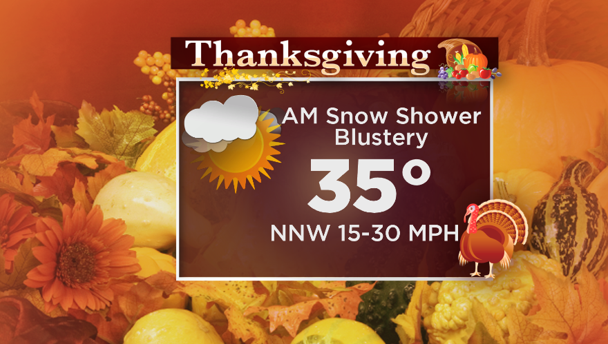
Some towns, again mainly hills, will wake up to a shallow blanket of white on Thanksgiving morning. And regardless of whether you get snow or not on the tail end of this storm, it will be a very chilly Thanksgiving this year. Bundle up for the backyard football game or 5k, with highs in the low/mid 30s and plenty of gusty northwest winds! May be a little difficult for the balloon handlers at the Macy's parade in NYC, too (must-see TV?).
The cold will linger through the upcoming weekend, with a shot for some light snow to move in on Sunday. Still a ways out and lots of hurdles to clear before we get there, but bottom line is to keep a stack of wood ready for the fireplace for the next 7 days.