Storms To Break The Humidity
This is not your typical average weekend. There really is so much going on , I did not know where to start this morning. My head is spinning...but in a good way! So let's get it started! Low clouds in place this morning trapped under an inversion will be tough to erode for many places. Some may be stuck in the clouds for much of the day.
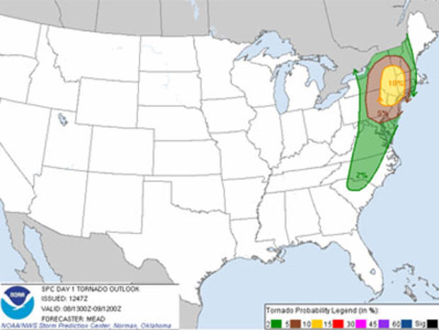
Related: Possible Tornadoes Touch Down In New York (VIDEO)
On the Cape there is sunshine! A gorgeous morning. I do expect a gradual thinning and lifting to the clouds for partial sun to emerge by the late morning into the early afternoon. I think we are looking at a decent beach day for sky conditions, once the clouds burn off, but wind and waves may be another issue. Any emerging sun will help to fuel the development of afternoon storms.
Check: Current Conditions | WBZ Weather Blogs | Interactive Radar
Winds out of the south will be picking up through the day with gusts to 20-30 mph this afternoon. It is a warm and humid wind direction which will help to pump temps to near 80-85 this afternoon. Where there are clouds...a bit cooler in the Lwr 80's. 70's are likely on the Cape as Southerly gusts will keep it a bit cooler. A high surf advisory in place for south facing beaches thru 8 AM Sunday with a high risk of rip currents, some beach erosion, and rough surf. Seas will build to 4-8 feet during the weekend with the largest swells off the south coast. Obviously, this swell is being generated by Tropical Storm Leslie which will remain hundreds of miles off the coast of New England. Still, please use caution at the beaches this weekend especially with children. Rough surf can be fun to body board in, but if you do not know how to handle a rip current can become deadly. People were being pulled from the water yesterday, I am sure there will be more before the weekend is through.
A strong low level jet with gust to 50-60 mph aloft will help thunderstorm development this afternoon as low level moisture will increase up the coast. This upper level wind shear will promote a turning with wind with height which mean the potential for a few pulse type super cell storms to form in the early-mid afternoon in western New England...drier at the coast. These storms will come with heavy rain, and the potential for damaging winds. These will be mainly scattered convection along with a warm front which will be pushing through SNE during the afternoon. Some of these showers and storms may try to push eastward and reach the coast between 5-7 PM...but again...scattered hit or mis storms...with heavy downpours.
Tonight will be the main event with a severe line of storms moving from NY, PA into western New England. This line will be bowing with straightline winds which will likely produce winds over 60mph down to the ground with widespread wind damage happening from S. VT to Western MA into CT. Because of the strong winds aloft ahead of this approaching front, there is an increased risk for rotating storms and the potential for isolated tornadoes...again the best chance for this is Western New England between 6-9 PM.
As these storms work eastward tonight without the energy of the Sun, they will loose the support to maintain their strength, but still can not rule out a few isolated severe storms reaching the coast from 10 PM to midnight...but a definite weakening trend...compared to the western storms.
The front will be pushing to the coast during the early morning hours Sunday where clouds will linger at the coast during the morning hours with shoowers on the Cape and possibly into SE MA. The Euro this morning had a rather ominous look for Sunday morning in SE MA, so I am interested to see if that trend continues. Luckily, the pattern is progressive...so any morning clouds or showers which are there during the morning will be pushing off the coast with clearing skies from west to east. Everyone will see increasing sunshine Sunday by afternoon with falling humidity. Clouds may linger on the Cape. The threat of rip currents will not be going away either. In fact, the largest swell for Leslie will likely wait for Monday to finally arrive where seas could build up to 10 feet off the coast.