State Of Emergency In Effect For Mass. Blizzard
Updated 12/27, 8 a.m.
BOSTON (CBS) -- Tens of thousands of people lost power and roads were treacherous to pass, as Massachusetts was hit with its first blizzard since 2005.
Gov. Deval Patrick declared a state of emergency through Monday, and State Police urged everybody to stay off the roads.
Podcast
Listen To Patrick's complete press conference.
Conditions deteriorated rapidly Sunday afternoon. By early Sunday evening several inches of snow had already accumulated in southeastern Massachusetts. By later in the evening, the snow was piling up and conditions were dangerous.
At the peak of the storm overnight, more than 50,000 households were without power.
Non-emergency state employees who work in the Executive branch were told not to report to work on Monday. All RMV branches closed on Monday, courthouses delayed opening until noon, and several cities and towns also closed their offices for the day.
WHAT TO EXPECT
The National Weather Service issued a blizzard warning through 12 p.m. Monday for all of Eastern Massachusetts except for the Cape and Islands.
A blizzard (technically) is when winds are sustained over 35mph, causing the blowing and drifting of snow to reduce visibilities to less than quarter of a mile for at least three hours. Visibility at times was near zero.
Gallery: WBZ Accuweather Forecast Graphics
Read: Snow Emergency List
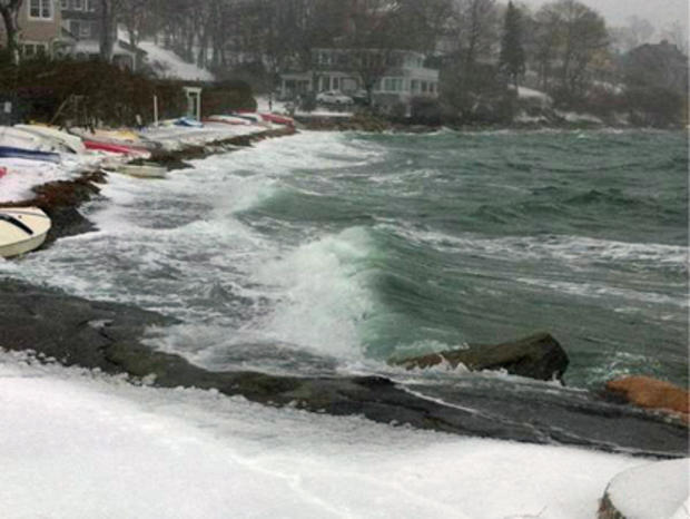
A coastal flood warning from Newburyport to Plymouth expired at 8 a.m. Monday. The overnight high tide caused flooding and evacuations in several coastal neighborhoods.
Read: National Guard Responds To Coastal Communities
Watch: Latest WBZ Accuweather forecast.
STATE OF EMERGENCY
At a press conference at the MEMA bunker on Sunday, Gov. Deval Patrick called for a state of emergency. "The snow will be wet, heavy. Temperatures will be at or below freezing and winds will be high. These are conditions that pose a substantial risk of power outages," said Patrick.
Patrick urged people to stay off the roads Sunday night and Monday morning. "We expect visibility by then to be very low and travel to be extremely dangerous."
The declaration of a state of emergency allowed Patrick to mobilize many of the Commonwealth's assets, such as the National Guard.
HOW MUCH SNOW WILL WE GET?
Snow fell at rates of 2 inches to as much as 4 inches per hour overnight, piling up quickly.
WBZ meteorologists are forecasting a widespread 12-18 inches with pockets of up to 2 feet of snow by Monday midday when the snow winds down.
Amounts will be less in extreme southeastern Massachusetts and over Cape Cod where rain mixed in.
Winds were strongest at the coast, 25-50 mph with gusts well over 60 mph. Wellfleet reported wind gusts topping 80 mph at times.
WHAT'S BOSTON DOING?
The city of Boston's snow emergency began at 3 p.m. on Sunday.
Boston deployed 500 pieces of snow removal equipment and nearly 25,000 tons of salt to clear the snow.
The City of Boston Storm Center was also activated to provide information and service to Boston residents for all storm-related issues. Residents with storm-related questions or concerns should call the mayor's 24-hour hotline at 617.635.4500.
TRAVEL DELAYS & CANCELLATIONS
While Logan Airport technically remained open throughout the blizzard, most airlines cancelled their flights into and out of Boston. Phil Orlandella of Massport said it could take through Friday to clear all of the travel backlogs.
Read: Airline contact information.
Podcast
Massport's Phil Orlandella Updates Logan Airport Situation
Amtrak service between Boston in New York was shut down Sunday afternoon. Limited service resumed Monday morning.