Western And Central Massachusetts Mark 10 Years Since Devastating Tornado On June 1, 2011
SPRINGFIELD (CBS) - Every spring and summer, thunderstorms flare up and move across New England. Lighting up the sky and bringing relief from heat, they're usually more exciting than terrifying.
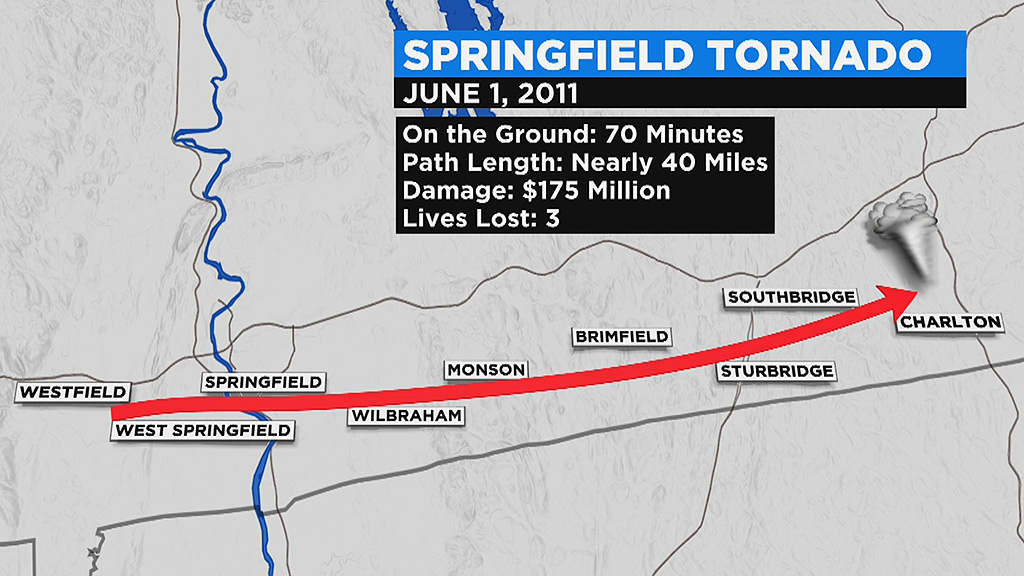
But 10 years ago, one thunderstorm grew to a level not seen in decades. Over the course of 70 minutes, that storm would go on to ravage cities and towns along a 38-mile path from Westfield to Charlton. Three lives were taken, and 200 others were injured. No one had seen anything like it since the Worcester tornado in 1953.
Unfortunately, Americans had already endured a lot of severe weather in the months leading up to June 1, 2011 outbreak. It began with a tornado outbreak across the south in late April, moved to Joplin, Missouri in May, and then danger came to the unlikely location of Massachusetts to start June.
From a forecast perspective, there was ample notice that something significant was brewing. The Storm Prediction Center (SPC) in Norman, Oklahoma outlined New England for severe weather five days earlier. The region was put on alert for severe storms each day leading up to the event. And on the afternoon of the 1st, a Tornado Watch was issued.
Photos from June 1, 2011: Tornadoes Tear Through Massachusetts
Setting up the conditions for tornadoes, a warm front came through during the morning with a round of rain and storms, some of them already producing hail. Behind the front temperatures moved into the 80s, along with a large uptick in humidity.
WBZ-TV Weather Producer Terry Eliasen, was working all day and made note of the more technical variables meteorologists look at when deciding whether rotating supercell thunderstorms will develop:
- 1) The Lifted Index: This is a model forecasted number we look at as meteorologists during severe weather. Lifted Index is one of the most common ways to measure how unstable the atmosphere is. The value is obtained by computing the temperature that air near the ground would have if it were lifted to a higher level (around 18,000ft typically), and comparing THAT temperature to the actual temperature at that level. Negative values indicate instability…the more negative the number the more unstable the air. A typical severe weather day we may see LI's somewhere between -1 and -5, but on Wednesday, the LI was in the range of -8 to -10.
- 2) CAPE: This is another important meteorological term, which is short for Convective Available Potential Energy. Simply put, this is the measure of the amount of energy available in the atmosphere for convection (severe weather). CAPE is directly related to the maximum potential vertical speed within an updraft (in other words, how fast can the air rise within a thunderstorm); thus, higher values indicate greater potential for severe weather. Observed values in thunderstorm environments often may exceed 1,000 joules per kilogram (j/kg), and in extreme cases may exceed 5,000 j/kg. Wednesday's values approached 4,000 joules in Western Massachusetts.
- 3) Helicity: This is one more very important meteorological factor, especially with tornadic development. This one is perhaps the most difficult to explain. It is a measure of spin in the atmosphere and is measured by looking at a vertical wind profile of the atmosphere. The more wind shear you have (wind blowing at different speeds and directions in different layers of the atmosphere), the greater the rotation within a storm. Generally you are looking for a helicity number of 150 or greater for any type of significant rotation, and Wednesday's readings were between 200-300 in the bottom 3-km of the atmosphere.
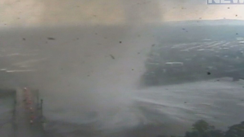
Everything was in place for explosive supercells to form, and indeed they did. By 4 p.m., several of them were descending from the Berkshires into the Connecticut River Valley.
At 4:15 p.m., a clearly rotating storm capable of producing a tornado swiftly moved into Westfield.
And at 4:17 p.m., the first touchdown came in the Munger Hill section of the city, where the elementary school was damaged.
In West Springfield, the first tragic death occurred when Angelica Guerrero was crushed by the roof caving in. She was in the bathtub, protecting and covering her 15-year-old daughter. She was doing everything right, but it wasn't enough to survive when her home collapsed.
As the tornado set its sights on downtown Springfield, some of the most dramatic visuals of the storm took place. The swirling debris was captured by a tower camera as it made a jump across the Connecticut River alongside the Memorial Avenue Bridge.
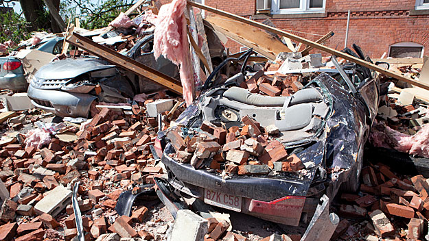
The time was 4:38 p.m., and the city has held moments of silence at that time every year since. Numerous homes and businesses in downtown Springfield were damaged or destroyed. The Island Pond neighborhood would take a major hit, striking Cathedral High School, St. Michaels, and dozens of homes.

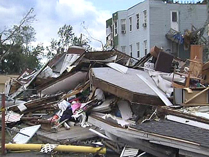
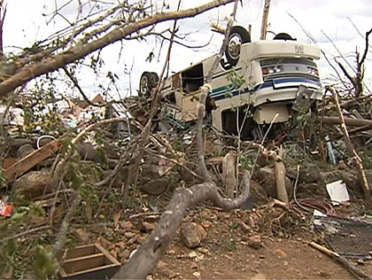
Onward the tornado would track, through Wilbraham before reaching peak intensity in Monson and Brimfield where 160mph winds and EF-3 damage took place. Here, in the Brimfield State Forest, the tornado would reach its max width of a half-mile wide. The Monson High School was destroyed, along with nearly 10,000 acres of woodland. An absolutely terrifying scene would play out in Brimfield at the Village Green Family Campground, where 95 of the 97 camper trailers parked there at the time were destroyed and one woman was thrown from hers and killed.
The last stop was in Southbridge, where the municipal airport was damaged. Finally, it lifted in the southwest corner of Charlton. Debris would be found as far east as Natick. Though it was not the only tornado of the day. Another supercell to the north, 2 hours later, would skip and produce three short-lived tornadoes in Wilbraham (EF1), North Brimfield (EF1) and Sturbridge (EF0). In the end, the Massachusetts Division of Insurance reported 9,500 insurance claims that added up to $175 million worth of damage.
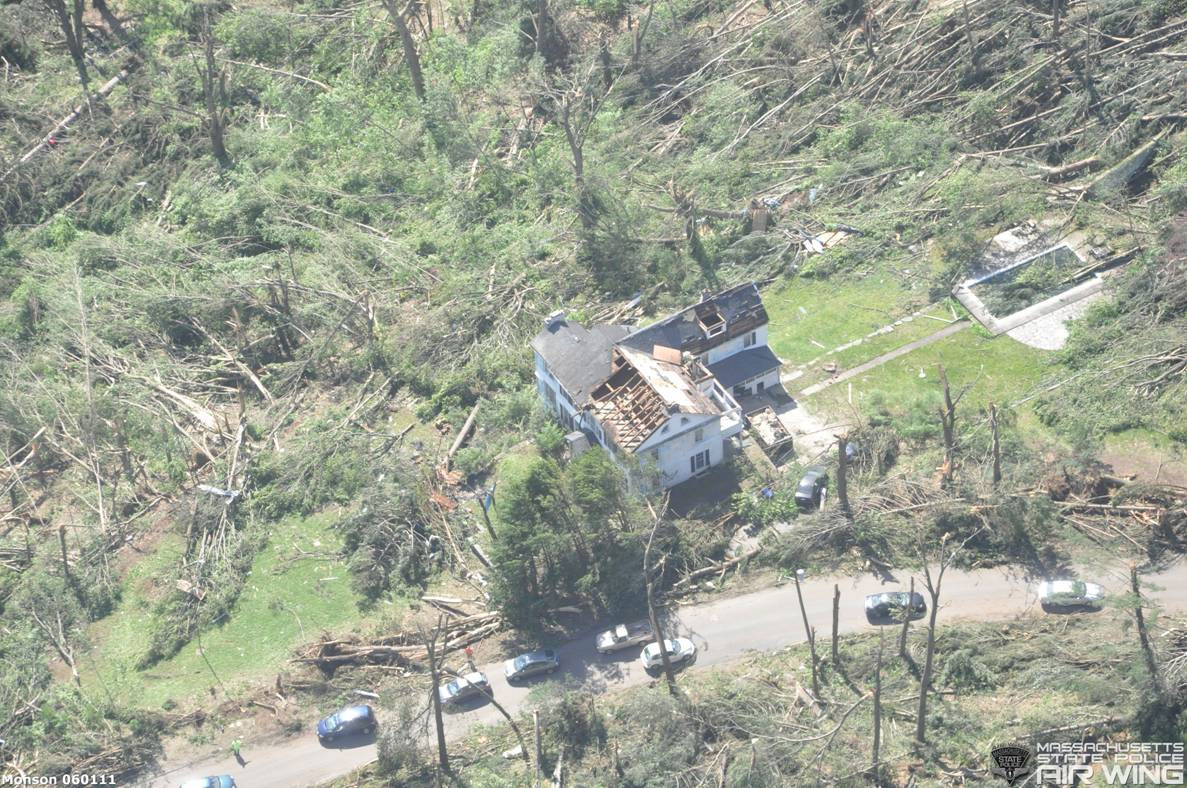
For years afterward, the scar gouged into the earth was visible to anyone driving by the path or flying overhead. Snapped trees marked the track along Route 20, or for travelers getting on I-84 in Sturbridge. And in the winter, so notable was the disappearance of trees that snow would fill the scar and show up on satellite imagery, producing a striking outline from space that perfectly traced the path of destruction. A decade later, this was one of the first winters that the scar was hardly visible. Nature is slowly healing, but memories of survivors will stay sharp for the rest of their lives.