Slow And Steady Storm Could Dump 2 Feet Of Snow
BOSTON (CBS) -- It has become a tradition. For the third week in a row, we are in for a sizable snowstorm to start the work week.
Two weeks ago it was the blizzard. Starting on Monday, the Blizzard of 2015 raged all day Tuesday and left many schools closed for several days to follow.
Check: Weather Blog | Current Conditions | Share Photos
Last week it was the Groundhog Day Nor'easter, another early week storm with most of the snow coming on Monday, once again putting many schools and businesses on hold until midweek.
And here we go again. This week's episode has already begun with several inches on the ground well before the first miserable commute.
Three weeks, three big storms, all very different in their duration and makeup, but all with one thing very much in common -- a lot of snow.
If I were to characterize this storm in just a few words it would be, "slow and steady." No raging winds, no coastal flooding, no 3" per hour bands of snow, just hour after hour, day after day of light to moderate snow. From this standpoint it should be the easiest storm of the bunch to keep up with. Snowblowers and plows should have no trouble clearing the way with a methodical and persistent approach. The biggest problem this go around...where the heck to put all this new snow.
Once again, let's take you through the next couple days and help you devise a plan of attack.
Through Monday 7 a.m.
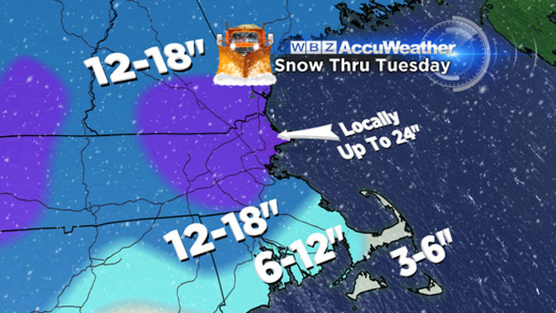
The snow strikes back. Once again the radar will fill in and steady snow will overspread the region. Expect an additional 3-6" of snow in all of Southern New England. The exception would be over the South Coast, Cape and Islands, only 1-3" in that region due to some mixing with sleet and perhaps freezing rain. By Monday morning the total snow so far will be 6-10" anywhere north of a Plymouth to Providence line. South of there, storm totals will be 2-6".
Monday 7 a.m.-5 p.m.
The snow continues. Another 3-6" will accumulate during the daylight hours on Monday (except for the Cape and Islands). Many towns will be near or over the foot mark by the evening commute. Storm total accumulations by 5 p.m. Monday: 8-14" from Plymouth to Providence and all points north...4-8" from Cape Cod north to Plymouth...2-4" on the Islands
Monday 5 p.m.-Tuesday 7 a.m.
The final act from this seemingly never-ending snow barrage. . . several more inches fall overnight. Finally, by Tuesday morning, the snow will begin to taper off and all the accumulation will be done by 7 a.m. Just some lingering light flurries near the coast Tuesday morning.
Storm total accumulations by 7 a.m. Tuesday (FINAL STORM TOTALS):
10-18" from Plymouth to Providence and all points north. . . 5-10" from the Cape Cod Canal north to Plymouth. . . 2-5" from the mid to outer Cape and the Islands.
Could there be MORE than 18" somewhere? Absolutely...
"Jackpot" zone. . . expect the highest snow totals to be just to the north of Boston in parts of Essex and Middlesex Counties due to a coastal front and ocean enhancement. In this zone 18-24" is by no means out of the question.
Winds: Not a major concern this time. There will be a persistent east-northeast wind for the duration of the storm, peaking from Sunday night through Monday night. Gusts will top out between 40-45 mph at the coast in this time period.
Coastal Concerns: Tides are astronomically low. This is not going to be a coastal flooding event. However with several days of onshore winds over multiple tide cycles, significant beach erosion in likely.
Looking ahead, there is absolutely no relief from the cold or the snow in sight. There is a real possibility of another significant snow storm in the Thursday/Friday timeframe. Following that, some of the coldest air, perhaps in years. We may challenge some record lows here later Friday and over the weekend.
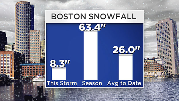
When all is said and done this will no doubt be a winter for the record books. We will likely challenge the coldest and snowiest February's ever recorded and perhaps even approach the snowiest winter ever in Boston, 107.6" back in 1995-96.
A winter to remember. .. and one we will likely try to forget.
Follow Terry on Twitter @TerryWBZ


