Temperatures To Take 'Arctic Plunge' Monday Evening
BOSTON (CBS) --- You've probably heard by now, some of the coldest air in many years is currently pouring down from Northern Canada into the Midwest. As of this writing, the current temperatures in cities like Chicago and Minneapolis is around-15…yes those are actual air temperatures, not wind chills. Adding in the wind, it feels like -40 to -70, near historic cold and certainly life threatening.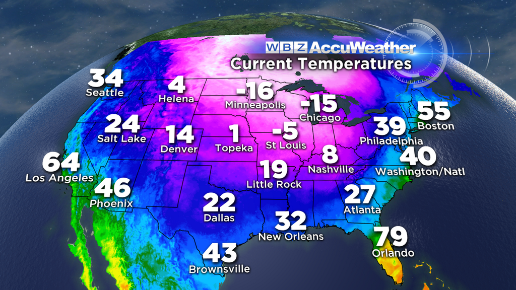
So what is causing this? Something call a "Polar Vortex"…sure sounds cold and menacing right? Essentially it is a very large area of low pressure which typically swirls around the Polar regions during this time of year. On rare occasions, a piece of this vortex can break off and dive southward literally from the North Pole and bring the Arctic down to the United States. This time, the vortex just happens to be escorting an air mass that would even make the Eskimos of the Arctic bundle up.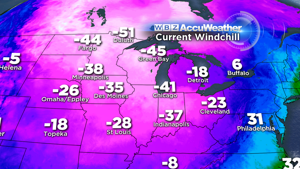
So, will it come here, to New England? The answer is yes, but in a bit of a modified state. Thankfully, we will not have to deal with the core of this Arctic plunge. As it moves eastward tonight, it will not be nearly as harsh. In fact, the majority of this Arctic air will actually pass well to our north into Eastern Canada. However, we are still going to be fringed, beginning later tonight and lasting through Wednesday morning.
Here is our cold timeline:
Temperatures will plunge later this afternoon, from the balmy 40s and 50s down to the 30s during the evening commute. Temperatures will likely dip near or below freezing well to the north and west of Boston. Some icy spots may develop as this flash freeze works into Southern New Hampshire and parts of Central and Western Massachusetts between 4-6 p.m. By 7-8 p.m., the cold air arrives in Boston and all of Southern New England dips below freezing. All standing water on untreated surfaces, roads, decks, sidewalks will turn to ice. Temperatures will continue to drop overnight and by Tuesday morning, most towns will be in the teens with wind chills near or slightly below zero.
Check: Current Conditions | Interactive Radar | WBZ Weather Blog
During the day Tuesday, we will have "ineffective sunshine," in other words the sun will be out, but it will have little effect on temperatures. Our entire area will stay in the teens on Tuesday with persistent gusty winds 15-30 mph making it feel below zero.
Watch Eric Fisher's Latest Forecast
Tuesday night into Wednesday morning the winds will die off and the temperatures will plunge even more. Most of the suburbs will dip below zero and Boston will likely dive to around 5-8 degrees. Not record cold, in fact, not even the coldest of the year (that came just a few days ago during and after the Nor'easter), but it will still feel downright frigid outside.
The cold will begin to ease later this week and by Friday we should manage to climb back above the freezing mark for the first time in four days.
And an early peak at the Pats game on Saturday night actually looks fairly mild, near 40 with some rain showers in the area. Could have been a whole lot worse.
Follow Terry on Twitter @TerryWBZ