Torrential Rain Coming Friday, Slim Chance Of White Christmas
BOSTON (CBS) - Our last full day of fall is today, winter officially begins at 6:12 a.m. Friday.
How fitting that as we speak there are blizzard warnings blanketing a large area in the Midwest.
Check: Interactive Radar | Current Conditions | Weather Blogs
Winter is arriving a day early in parts of Iowa, Kansas, Wisconsin and Michigan, but in good ol' New England we continue to wait… and wait… and wait.
It seems like we have been waiting for two years now, with the nearly snowless winter we had last year.
The most popular question to our weather team lately - "Is there any chance of a white Christmas?"
The answer remains very little.
The blizzard in the Midwest is indeed headed our way, but it will look nothing like it does in its current form. As with many other storms preceding it, this storm will head generally to our west, drawing mild air in ahead of it and arrive in New England wet, not white.
There could be just a hint of wintry precipitation after midnight tonight in the northern Worcester Hills and in parts of southwest New Hampshire, but the cold air is going to lose this battle quite handily.
FRIDAY FORECAST
Strong southeast winds will push mild air all the way into parts of central and northern New England and by dawn on Friday it will be all rain and becoming heavy.
As the core of the rain moves from west to east Friday morning and midday it will resemble that of a summertime squall line - lots of yellows and reds on the radar, passing through Boston just after midday.
This torrential rainfall will pull down some very significant winds from a few thousand feet up in the sky, this will be our biggest concern.
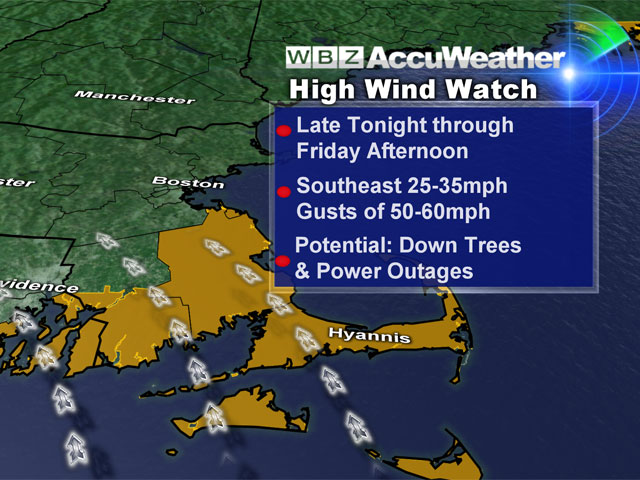
Winds will gust from 25-50 mph perhaps even up to 60 mph in parts of southeastern Massachusetts. This will be enough to cause many downed limbs and trees and perhaps some scattered power outages. It will all end rather quickly Friday afternoon. The rain will shut off and the winds will decrease significantly by the time you take to the roads for the evening commute.
THE WEEKEND
Behind this storm, cold air will rush in and winter will feel more like winter this weekend.
The storm will park itself in northern New England, leaving us under its influence Saturday and Sunday, with cold gusty winds, intervals of clouds and the chance of some scattered snow showers and flurries. That is our last shot at whitening the ground a bit before Christmas.
CHRISTMAS FORECAST
As for the holiday, no major storms or weather issues are expected in New England.
Christmas Eve will be sunny, dry and cold.
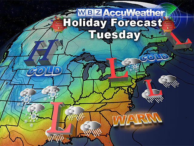
Santa should have clear sailing Monday night. And then, a very small and weak disturbance comes through in pieces on Christmas Day, bringing a chance of some snow flurries to decorate the landscape.
Our official Christmas Day forecast: increasing clouds, cold, with temperatures in the 30's and a chance of some light snow.
You can follow Terry on Twitter at @TerryWBZ.