Summer Weather Forecast: Dry To Start, Wetter Second Half
BOSTON (CBS) - "It's the most wonderful time of the year!"
But I don't mean jingle bells and holiday greetings either.
It's "summertime and the livin' is easy"!
While summer doesn't officially commence until the solstice at 6:07 a.m. on June 21st this year, we meteorologists, climatologists and many other people consider summer as the months of June, July and August with an unofficial kickoff of summer on Memorial Day weekend. By breaking the seasons down into groupings of three months based on the annual temperature cycle as well as our calendar, it becomes much easier to calculate seasonal statistics from the monthly stats, both of which are very useful for commerce and agriculture plus a myriad of other purposes.
Winter and summer are the two seasons that people are most interested in the weather. We all have this curiosity about how cold and snowy it will be in winter and how hot and sunny it will be for vacations in the summer.
So what is in the works in the next 90 days?
My Prediction Through September:
Over the past 4 years, I have submitted my summer forecast with special concentration on the number of 90-degree days in Boston. I have been fortunate in coming close to the actual numbers within a day or two each year.
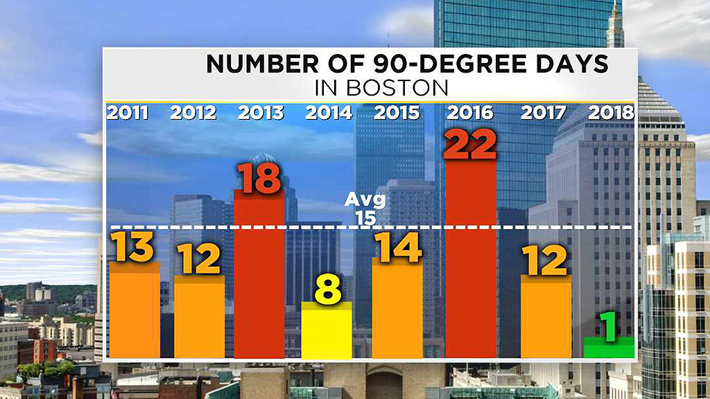
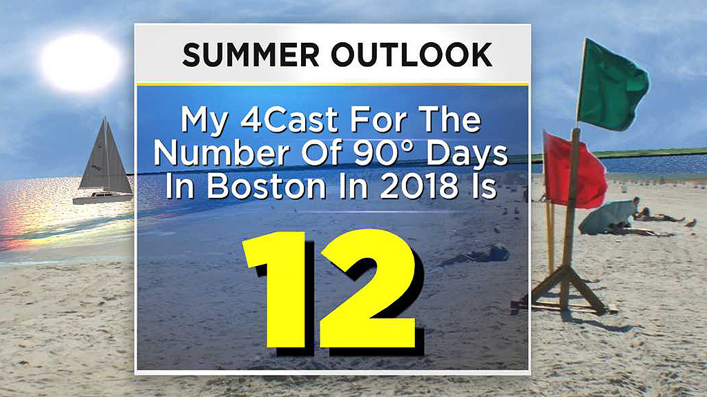
In 2014, I predicted 9 and Boston got 8. In 2016, my preliminary forecast issued in April was for 20-25 days at 90 or higher. By late May, I chose 22 and that worked out perfectly. Last year, I predicted 14 and the total was 12. This year I am forecasting 12 and that MAY be too liberal! By the way, the average number for Boston is 15.
Overall, my thinking is that the summer overall will end up with a mean temperature departure near to somewhat below average. June should end up above average but not quite at the level of last June that was +1.8 degrees. I am expecting July to be closer to average and a bit warmer than last July which was -0.9 degrees. August has the potential to be a bit below average which would be a bit cooler than last August which was flat. September may exhibit the biggest change as I think it will end up a bit below average which is much cooler than last September which was +2.2 degrees even though there were no days at 90. Beyond that, I am highly confident that we will not have a repeat of last October which was muggy and record-breaking yielding a mean temperature of a smashing +7.4 degrees.
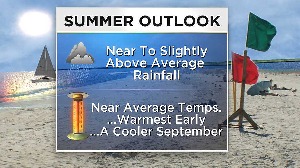
After a dry month of May and first part of June, most signs suggest a relatively dry first part of summer leading to a wetter second half of summer resulting in a near to slightly above average rainfall period through September. The wild card is determining the magnitude of tropical input. Overall, most signals indicate a near to below average number of tropical systems in the Atlantic and Gulf of Mexico this year but there is some reason to believe that the development region would be closer to the eastern seaboard so we will be watching the western Atlantic very closely.
Forecast Details & Reasoning
Are antecedent conditions a clue? Sometimes they are but other times they are not. Despite what some folks were saying about May, it was a very warm month with the mean temperature departure of a whopping +4.2 degrees!
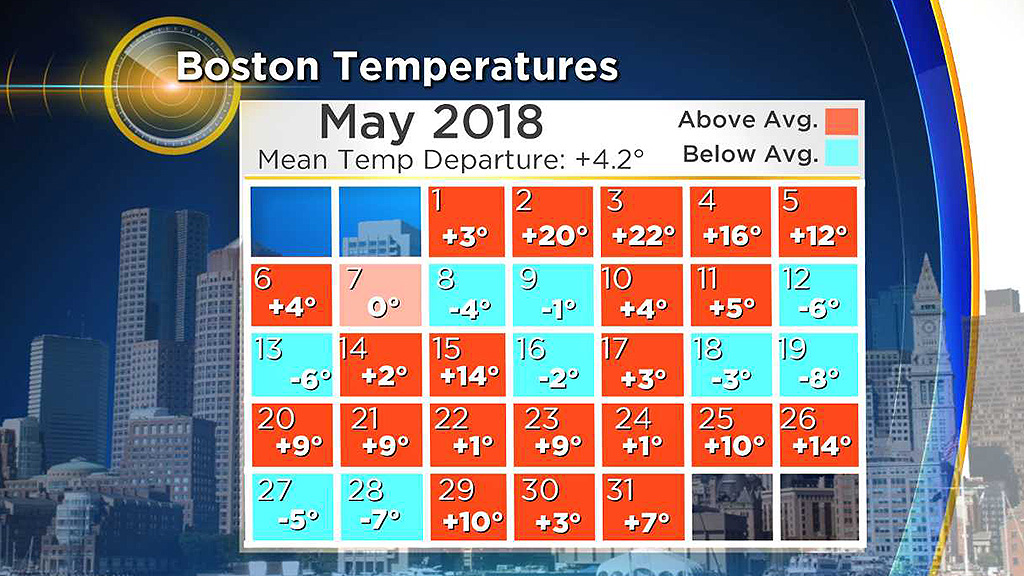
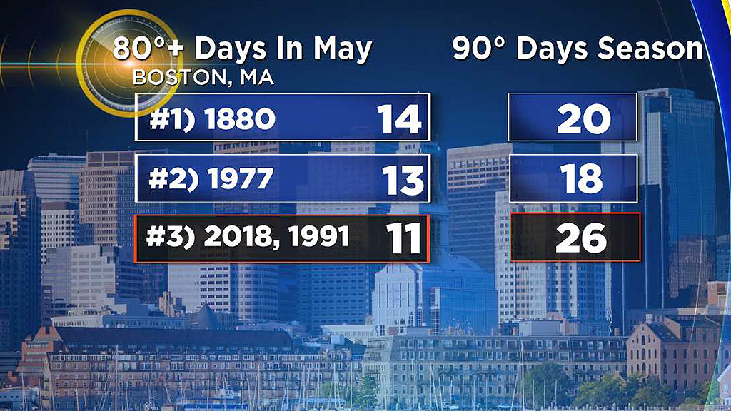
Boston got 11 days with a high temperature at 80 degrees or higher and that number is in third place tied with May 1991 and behind the 13 days of second place May 1977 and behind the 14 days of first place May 1880. For the corresponding number of days of 90 degrees or higher for the whole year, 1880 had 20, 1977 had 18 and 1991 had a mammoth 26 days! Since 2018 was tied with 1991 for the number of 80-degree days in May, can we assume that 2018 will be a scorcher with approximately 26 days at 90 or higher? Absolutely not. It's all about the roughly two dozen primary global factors with emphasis on El Nino/Southern Oscillation conditions and the locations of the sea surface temperature anomalies (pools of warmer and cooler than average water) across the Atlantic and Pacific oceans.
Examining the present state and model projections of ENSO and ocean temperatures, we can research analog years which exhibit similar characteristics and apply those findings and trends to upcoming seasons. Interestingly, the previously mentioned years of 1880, 1977 and 1991 are not analog years so that could indeed be one strike against forecasting many days over 90 this summer solely based upon how warm May was. More importantly, the ENSO trend of transitioning from a multi-year neutral/weak La Nina to a weak or possibly moderate Modoki El Nino is much more telling. In other words, there is an evolution unfolding in which the equatorial Pacific is warming especially sloshing more toward the central then eastern Pacific.
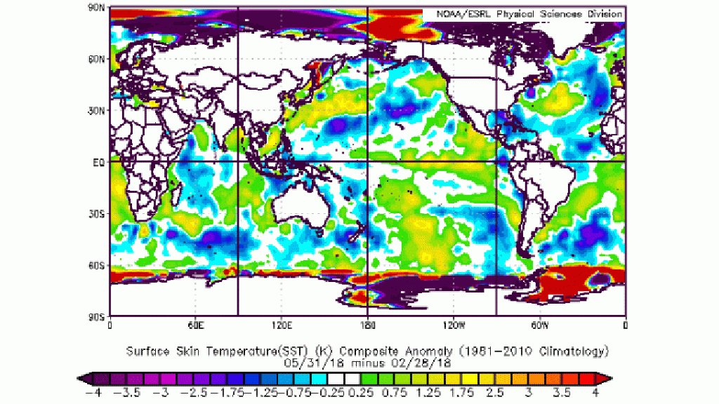
That fact plus all of the warm water in the entire eastern Pacific Ocean is suggesting via those analog years that the summer will trend cooler than average particularly later in the summer blending into fall. The warm eastern Pacific triggers atmospheric ridging there extending into the western part of the U.S. Downstream troughing over the central states would limit the magnitude of heat in the Midwest & Great Lakes eastward. Furthermore, the cooling of the North Atlantic has been instrumental in making eastern Canada eastward to Greenland very cold and snowy this spring. That is projected to be an additional factor in producing a cooler eastern U.S. summer along with the models forecasting lower air pressures across the Atlantic north of the tropics creating the absence of a strong Bermuda high pressure system to pump in the heat frequently.
In summary:
Most of the analog years had cooler summers with the number of 90-degree days in Boston under 12 so, as mentioned, my forecast of 12 days COULD be too liberal. The exception to the rule was 2002 which produced a remarkable 27 days over 90! The main difference was that the solar flux was way up during that period!
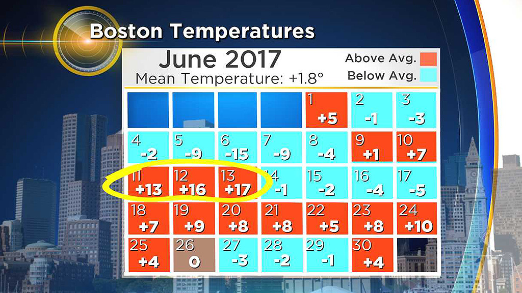
By the way, so far, Boston has just 1 day of 90 or higher this year. In 2017, May featured a heat wave from the 17th-19th. That was followed by a heat wave on June 11th-13th.
Long range forecasting for summer and especially winter is fascinating and made possible by the discoveries of many brilliant scientists and meteorologists. About 71% of the Earth's surface is covered by water and the oceans hold about 96.5% of all Earth's water. There is an amazing connectivity between the oceans and the atmosphere and brilliant scientists in and out of the government sector have worked diligently over the years to gain a greater understanding of this link. Thanks to their extensive research, there are around two dozen prime global factors that must be examined for long range forecasting. These include specific atmospheric and oceanic oscillations, the permutations in the phases of these oscillations, the solar cycle, geomagnetic activity, recent volcanism, storm track data, fall temperature and precipitation patterns including extent of snow cover from Siberia into western Canada, etc. It is a veritable atmospheric Rubik's cube and the finesse is determining which factor(s) will be dominant.
Finally - many thanks to the crew at WeatherBell Analytics for their insight and incredible knowledge in this field of long range forecasting.
HAPPY SUMMER!