When Will Spring Feel Like Spring?
Find Eric Fisher on Twitter and Facebook
Welp...it's almost April. Boston hasn't hit 50 degrees since the 1st of the month and most towns are staring at snow in the yard. Some more snow will fly this weekend. Highs will stay in the 30s Sunday and Monday. Sooooo.....will the weather start to match the calendar anytime soon? I think we're all starting to get a little cranky/fatigued with this late-winter surge, especially after getting so much spring weather in February. I know the tulips that have been up for over a month outside my apartment seem pretty ticked off about it.
And if it feels like deja vu, there's good reason. I undertook a Friday afternoon research project on a hunch to look back over recent years and see if we have qualitatively 'shifted' our seasons. Wouldn't you know it, we have lately! Many of you have probably had a hunch this was a case or thought about it in the back of your mind. But here are the hard numbers.

I looked at every month since January 2013 to see which featured warmer than average versus colder than average temperatures (using the most recent 30-year climo, 1981-2010, as a baseline). Turns out spring is the only season of the year that has featured more colder than average months than warmer than average ones (this year has already been included as colder than average, based on projections for the final 7 days). There has been a notable warming in summer and autumn, while winter is basically a wash. Spring, particularly early spring, has been extended winter.
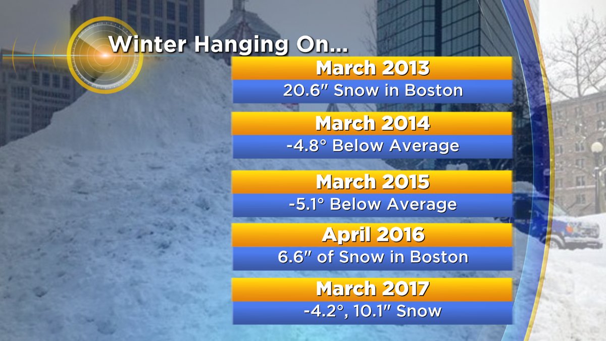
For no month is this more true than March. In the past 6 years, 5 have been colder than average. No other month has even had 4 in that time, making it particularly stand alone. The only year we had a warm March during this stretch was followed by a string of snowfall in April. We've really struggled to burst into spring. There has been some recent research into this recurring theme by Judah Cohen of AER, which you can read about here. The generally gist of it is that a warming arctic and decreasing sea ice is helping to promote more of these types of episodes.
Which leads us to the question - when will it actually feel like we've turned a corner? For some, the answer may temporarily be next week. Here's how the pattern is shaping up....
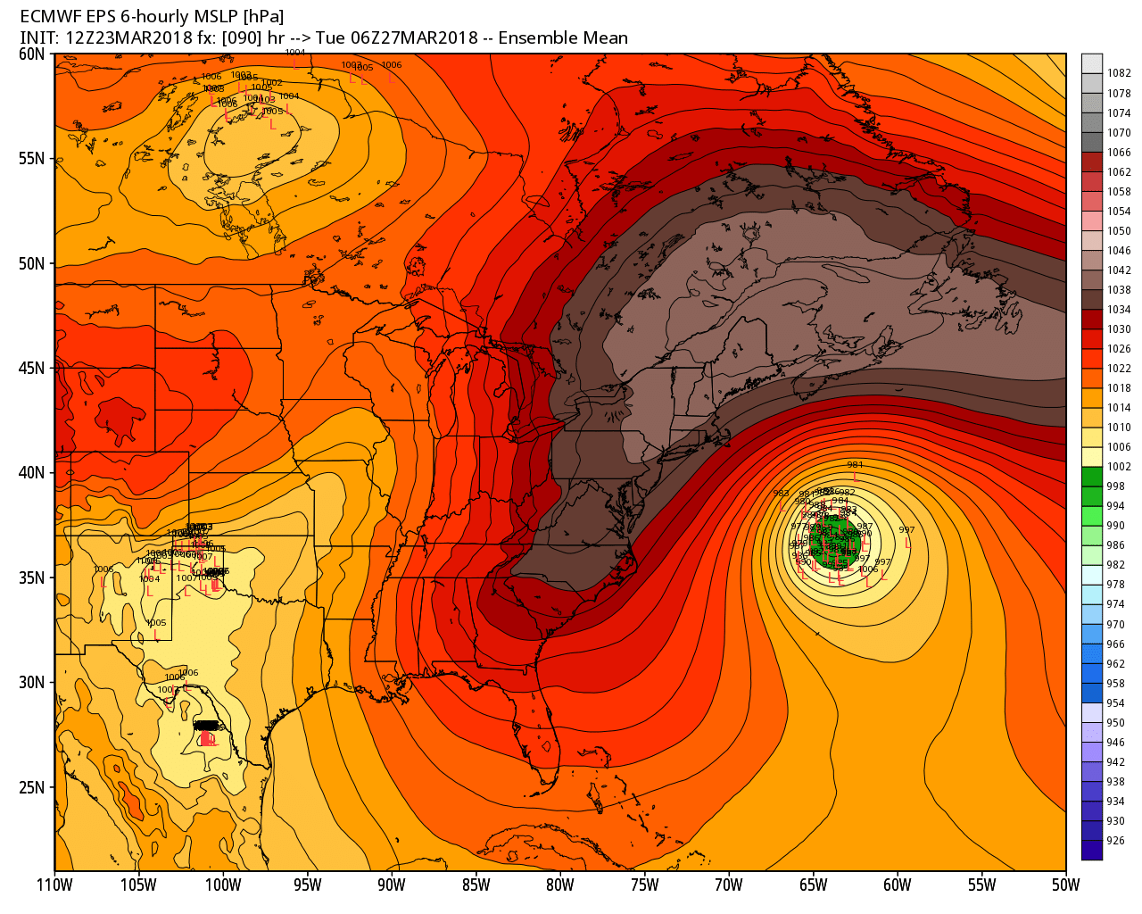
A huge sprawling area of cold high pressure will roll over the top of New England, accomplishing two things. First of all, it helps keep a strong coastal storm just offshore. It appears the only effects we will see are large surf (look for some big swell arriving Tuesday into Wednesday). Secondly, it helps keep winds generally onshore. There's nothing warm about an onshore wind in spring, so that will keep the chill going for coastal communities.
BUT those inland, especially from the 495 belt west, will get a taste of spring next week. Brighter skies, 40s and 50s, and the likely melting of the rest of our snowpack under the strong sunshine. The Connecticut River Valley will get the best of this stretch considering they already don't have any snow on the ground and they're well removed from the onshore flow. So if you need your fix, take a road trip to Amherst. I recommend Black Sheep Deli.
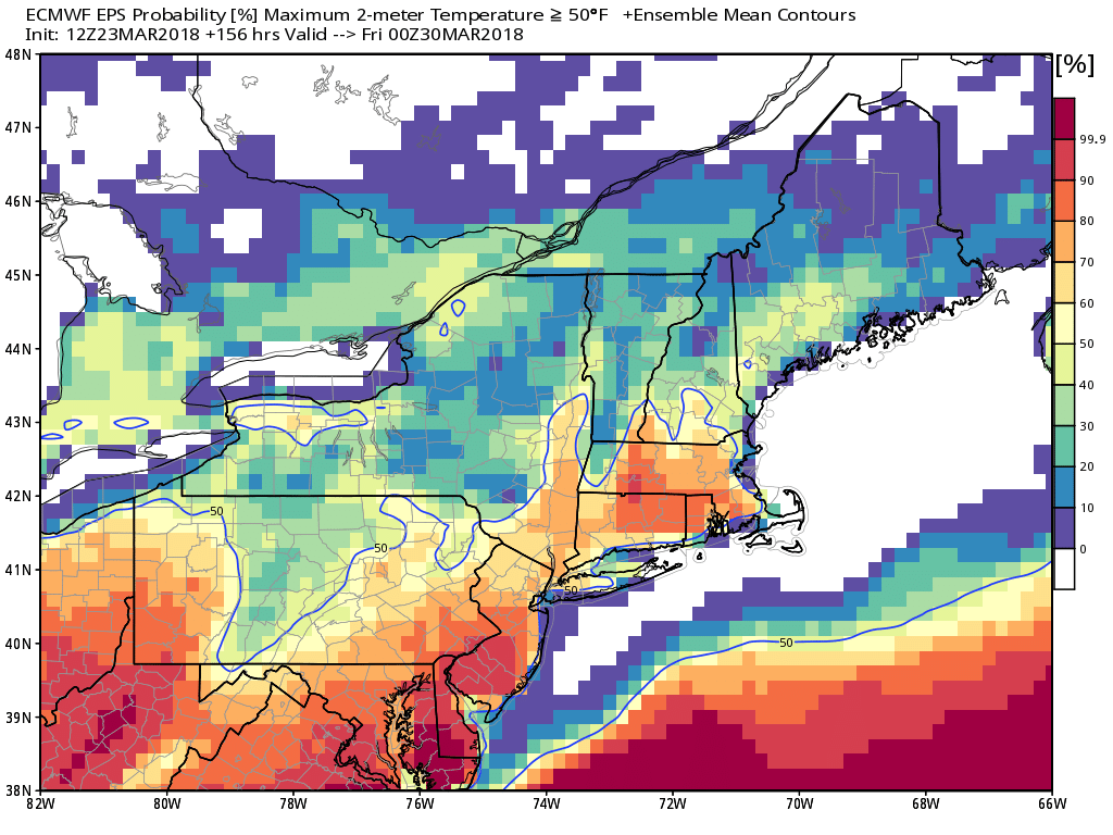
There's at least a decent chance that most of us get into the 50s sometime Thursday into Friday. I will admit, I am always conservative when it comes to putting warmth on an extended forecast this time of year. So much can go wrong and I don't like to get people's hopes up unless there is a darn good reason to go bullish on warm temps. I could envision a number of things going wrong at the end of next week. A storm track that currently looks west of us for Friday could easily end up locking colder air in place here locally as the inland low drapes a struggling warm front across the region. Or we could end up with secondary development near the coast, also helping to lock some Friday chill in place. Full disclosure! I think our best bet of some widespread 50s is Thursday and Friday could trend cooler. Will be quite happy to be wrong if it ends up warmer :-)
After that...welllllll
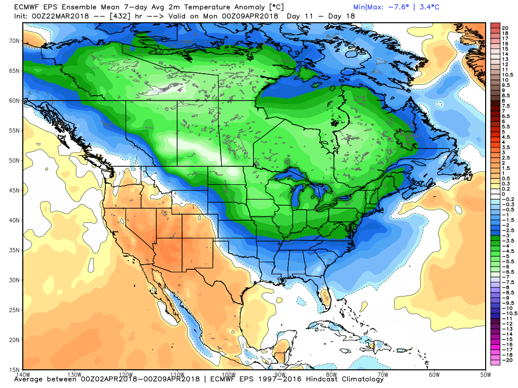
Most longer range guidance is hinting at a pretty sharp blast of chilly air for the first week of April. This is likely due to a re-curving typhoon expected in the western Pacific, which tends to lead to a pattern throwing cold down in the eastern U.S. Odds of this verifying are highest across the central U.S. and the Midwest, in my opinion. We'll be on the edge of it with slightly lower confidence of a cold stretch. One thing I could certainly say is that there isn't much of any signal for impressive/sustained warmth in early April, so we are going to have to wait a little longer for true spring conditions. Fear not because spring will burst into bloom regardless. Many of our early plants and trees are mostly driven by the increasing daylight, and by mid-April we should start to shake this pattern and jump into a greener landscape. The end is in sight and I think we're all ready for a little change in the seasons!