Nor'Easter 4 Won't Have The Impact Of The Other Snow Storms
BOSTON (CBS) - We got this. There is a light at the end of the nor'easter tunnel. Yes, our fourth nor'easter in three weeks is on the way, but, this one should be the least impactful of the series.
- Nothing comparing to the wind and coastal devastation of the March 2nd nor'easter.
- Nothing comparing to the massive tree damage and power outages of the March 7-8th nor'easter.
- Nothing comparing to the huge snow amounts from the March 13th nor'easter.
In the end, this fourth (and hopefully final) nor'easter may end up being nothing more than a forgettable footnote. There will be snow. There will be wind. There will be some coastal flooding. But it doesn't appear any will be memorable or nearly as impactful as our prior storms.
Still, a storm is coming, and we shouldn't let our guard down. I liken this to the Patriots playing three tough opponents in a row, coming out battered and bruised but victorious. It would be easy to overlook the fourth game against a much easier and weaker opponent. Channel your inner Bill Belichick, don't let the hapless Jets beat you. You've come this far, let's get you prepared for one more storm.
NO BIG DEAL DAYTIME
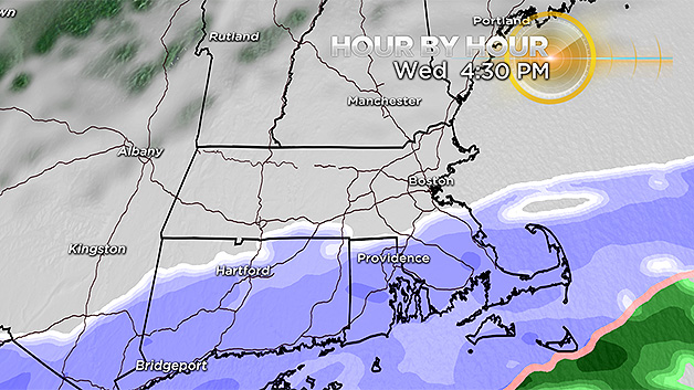
We are not anticipating any big issues during the daylight hours of Wednesday. The snow is going to be VERY slow to move northward. It will snow at times along the South Coast and eventually over southeastern Mass. by Wednesday afternoon but it will mainly melt on contact.
The evening commute north of the Massachusetts Turnpike should be a breeze, no snow at all in most areas. The evening commute south of the Pike will have minor issues, roads mainly wet.
STORM PEAKS OVERNIGHT
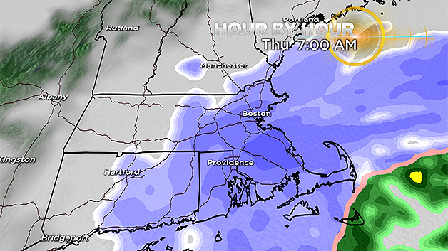
The majority of the snow and peak wind gusts arrive overnight, after 7 p.m.
There is still some question as to how far north the accumulating snow will reach. In fact, I wouldn't be surprised if many areas north of the Pike received even less snow than we are currently forecasting.
The snow will be running into a lot of very dry air as it tries to push northward and it remains to be seen how much progress it will make. Anyhow, light to moderate snow will fall through the overnight for most of southern and eastern New England.
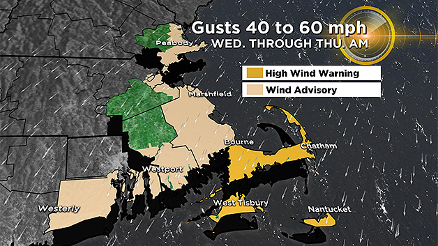
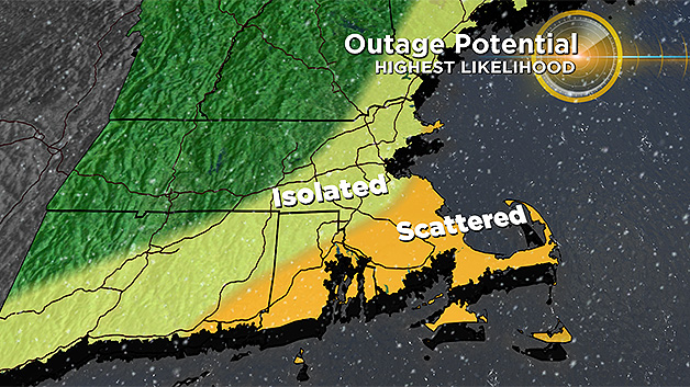
Winds will gust over 40-60 mph along the immediate coastline (highest over the Cape) and 20-40 mph inland. The greatest threat for scattered power outages will be over southeastern Mass. due to the combination of gusty winds and heavy, wet snowfall.
STILL SNOWING DURING THURSDAY AM DRIVE
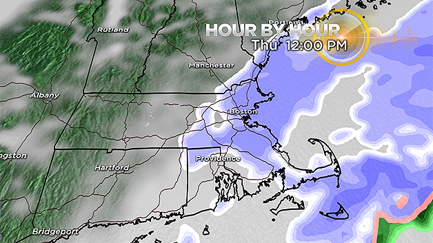
The snow will linger through most of the morning Thursday, gradually becoming lighter and more sporadic by late morning. The Thursday morning commute will be the "toughest" commute of this storm, although still nothing like some of the commutes of the past three weeks.
While most of the snow accumulation will be over by 7-8 a.m., there could be some small, additional accumulation though midday Thursday.
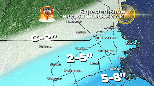
SNOW TOTALS WILL BE GREATEST SOUTH OF BOSTON
The highest snow amounts from this storm will actually not be in our area for once! The Mid-Atlantic will receive the brunt of this nor'easter with many areas down there exceeding a foot of snow.
CLOSER TO HOME
5-to-8 inches: Is our forecast for the areas along the Mass Pike from Worcester to Boston and all of southeastern MA down to the Cape Cod Canal.
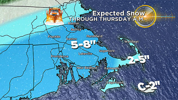
2-to-5 inches: Is our forecast for the mid and outer Cape as well as areas north and west of Boston (and north of the Pike) including northern Worcester county northern Middlesex county and all of Essex county.
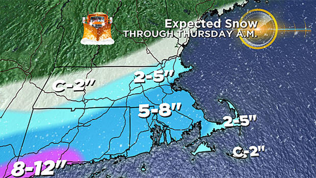
Coating to 2 inches: In areas farther northwest from the Berkshires through Southern New Hampshire and Southern Maine. Also Nantucket due to some mixing with rain.
COASTAL FLOODING MINOR
The only real high tide of concern is the Thursday early morning tide (between 2-6 a.m.) along the east facing shoreline of Mass. We are only calling for minor flooding with this tide cycle, a 1.5 to 2.5 foot storm surge and some 10-20 foot waves just offshore.
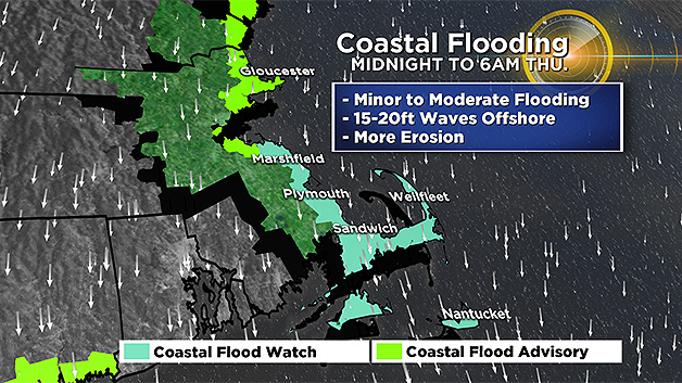
Beach erosion will continue to be a big issue, especially for parts of the Outer Cape and Nantucket.
NOR'EASTER 5?
Could this really be it?
Odds are heavily in favor of a MISS from the next storm over the weekend - a very large area of high pressure will be cresting over northern New England, suppressing the next storm well to our south.
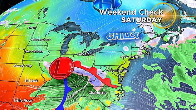
After that, things look relatively quiet for a while and there is a chance of actually reaching 50 degrees in parts of the area by the end of next week!
Baby steps. As always, we urge that you stay tuned to WBZ-TV and CBSBoston.com for updates before and throughout the storm.
Follow Terry on Twitter @TerryWBZ