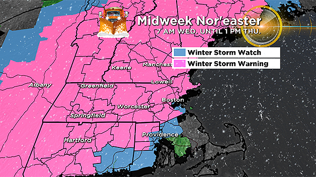
Second Nor'easter In Less Than A Week Will Bring Widespread Snow
BOSTON (CBS) - Ahh the signs of spring in New England…robins flying about, crocuses popping up, and nor'easters raging up our coastline…there's no place like home. Each and every year we get reminded that spring has an entirely different meaning for us than most of the rest of the Country. March can be a long and defeating month. Just when you thought you made it through another winter, suddenly someone picks up the finish line and moves it back a few miles.
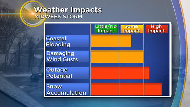
Right on the heels of one of the most destructive nor'easters in years, comes yet another coastal storm…a second nor'easter in less than a week. This one will be vastly different from the last though. Most importantly, the astronomical tides are MUCH lower (about 2 feet lower in many spots), so coastal flooding will be much less of a concern.
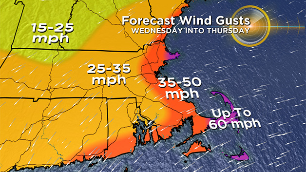
The winds will be much more "typical" of a classic nor'easter, perhaps gusting to 60mph, nothing to sneeze at for sure, but far less damaging than the 90mph gusts late last week.
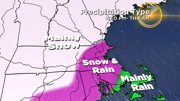
And finally, while parts of our area may still see some rain, the main impact from this week's storm will be snow, and potentially lots of it. This storm will likely end up being the second biggest snow producer for us this winter (the first being the Jan 4th nor'easter).
The biggest wildcard will be the location of the rain/snow line. While some areas are pretty much a lock for all snow (Worcester County and points west), other areas closer to the Coastline are going to be "riding the fence" between a heavy, wet snow and a cold rain.
Let's break it down the best we can for you at this point…
Wednesday Morning:
Some light rain and snow showers but nothing too consequential until well after the morning commute. After 9am, the precipitation becomes steadier and heavier. Not much wind just yet.
Wednesday Afternoon/Early Evening:
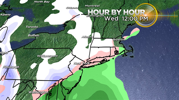
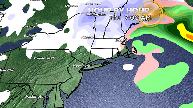
The rain and snow intensity increases dramatically. Snowfall rates of 1-2" per hour are possible in some of the heavier bands. Location of the rain/snow line still TBD but safe to say that all areas from 495 north and west will be snowing heavily, possibly all the way to 128…rain is likely in southeastern MA, most notably over the Cape and Islands. This will be a heavy, wet snow (as spring nor'easters typically are) with temperatures hovering very close to 32 degrees. Winds will begin to get gusty, about 20-40mph at the Coastline, 15-30mph inland. The high tide Wednesday is mid-afternoon (3:18pm in Boston) but only some minor flooding is expected.
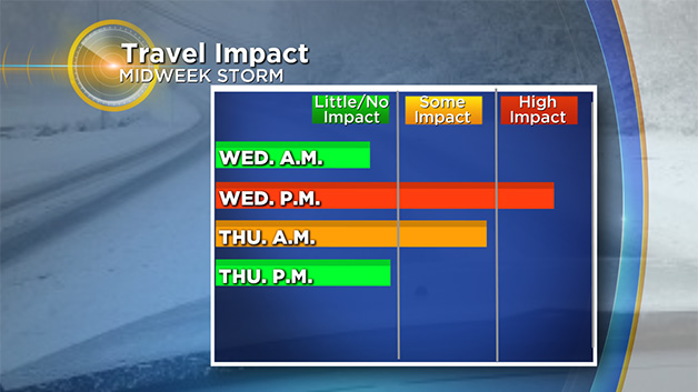
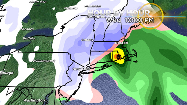
Wednesday Night:
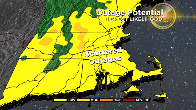
The storm intensity peaks Wednesday night…heavy snow is likely in most areas west of I-95 and as the winds turn more northerly later at night the rain/snow line will collapse all the way to the Coastline and into parts of southeastern MA. Winds overnight could gust as high as 60mph over portions of Cape Ann and Cape Cod, to 50mph for the rest of the Coastline and to 35mph inland. This, combined with the heavy, wet snow, will likely cause some tree and wire damage and additional power outages. One final high tide to watch around 3-4am, again, thankfully tides are not very high astronomically. With the strength and direction of the winds at that time, there may be some pockets of moderate flooding over parts of Cape Cod Bay and certainly at least minor flooding for the rest of the unprotected shoreline.
Thursday Morning:
The precipitation intensity will lower significantly after 7am Thursday, leaving just some final snow showers north of the Pike through the morning, very little, if any additional accumulation. As the storm pulls away, the winds will shift to the north-northwest and also gradually slacken off through the day on Thursday.
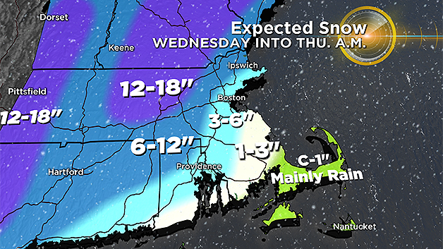
So How Much?
The highest snow amounts will be areas away from the coast.
Coating – 1 inch: Cape Cod and the Islands and far southern Plymouth County (Mainly rain)
1-to-3 inches: The South Shore, and parts of western Bristol County. (More rain than snow)
3-to-6 inches: Boston and Boston proper, extending into eastern Essex County then south to Providence (some mixing with rain, very heavy and wet snow)
6-to-12 inches: 128 north and west of Boston to 495 southward to northwest RI (mainly snow, heavy/wet consistency)
12-to-18 inches: Elevated areas of Worcester Hills, Monadnock Region, Berkshires, Southern Greens and Whites (perhaps as high as 16" or 18", fluffier consistency)
What's Next (Dare I Ask)?
Well, things quiet down through the weekend, temperatures climb to slightly above average by Saturday and Sunday (mid 40s) and don't forget, we turn the clocks ahead one hour Sunday at 2am!
BUT, our next potential storm threat comes Monday…way too early to tell if this will be a hit or miss, but it does appear that another sizeable coastal storm will form off the Carolinas late in the weekend. This one MAY stay too far south to hit New England, but being that it is still a week away, there really isn't much sense in speculating any more on this one.
As always, we urge that you stay tuned to updated forecasts on WBZ-TV and CBSBoston.com