'Blizzard Of 2018' Blasting New England
BOSTON (CBS) – If you were hoping to wake up to miraculous news of the storm taking a sudden right hand turn, sorry to be the bearer of bad news.
The Blizzard of 2018 is underway, it is going to be a wild day across New England.
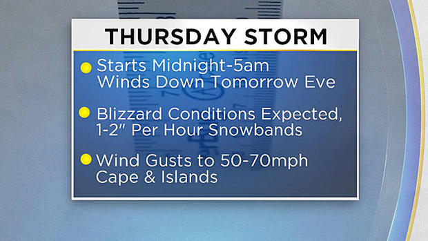
The combination of some intense snowbands (1-3 inches per hour) with winds gusting 50-75 mph will lead to a complete whiteout in many areas during the day today.
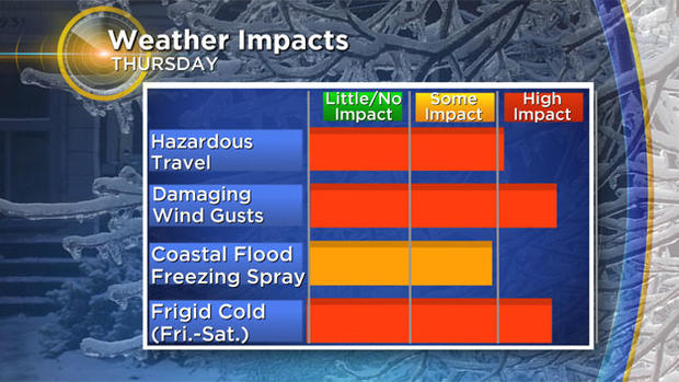
And then comes the cold - some of the coldest air in years will descend upon New England following this storm. All in all, the next 48-72 hours of weather will be some of the most dangerous and treacherous in recent memory.
Here's the step-by-step, hour-by-hour forecast for Thursday.
TIMELINE
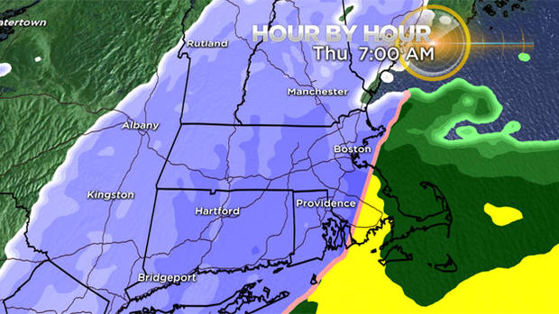
By Noon:
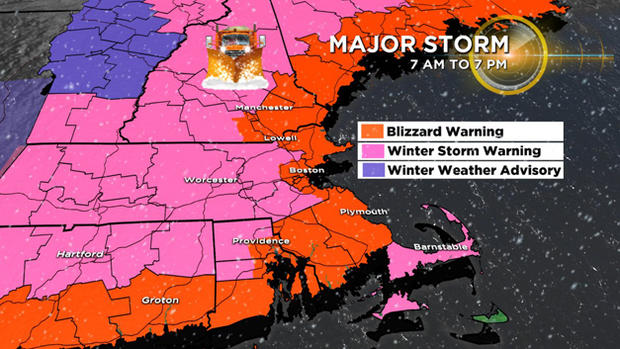
Between 7 a.m. and noon the storm really starts cranking. Steady snow overspreads the entire area with bands of heavy snow rotating onshore. The winds will also steadily increase out of the north-northeast causing near whiteout or blizzard conditions in some areas. Snowfall rates within some of the heavy bands could reach 1-2 inches per hour. Rain will continue to fall over the Cape and Islands and waffle off and on over parts of southeastern Massachusetts.
Road impacts: High
Snow accumulation by Noon: 3-6 inches
Winds: North 40-60 mph (Coast), 20-40 mph (Inland)
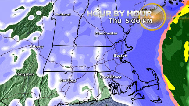
By 5 p.m.:
The afternoon is brutal. Bands of heavy snow and powerful, damaging wind gusts will pound the area. Driving will become very treacherous if not impossible at times in the whiteout. The rain will change to heavy and wet snow over the Cape later Thursday afternoon as the winds turn more north-northwest.
Road impacts: Severe
Snow accumulation by 5 p.m.: 6-12 inches (less Cape/Islands)
Winds: North-Northwest 50-75 mph (Cape/Islands/Immediate Coastline), 35-50 mph Eastern MA (Inland)
By 10 p.m.:
The snow winds die down between 5-10 p.m. and the moderate and heavy snowbands completely diminish and just some flurries are left. By 8-9 p.m. it should be safe to start the cleanup without any additional accumulation.
Road impacts: Severe (improving late)
Snow accumulation by 10 p.m.: Widespread 8-12 inches with pockets up to 15-16 inches (but less Outer Cape and areas well northwest)
Winds: West-Northwest 40-60 mph. Outer Cape, Nantucket, 20-40 mph rest of area.
This will be the biggest snow accumulation yet this season for most of the area.
ACCUMULATION
12"+
Best chance for seeing over a foot of snow lies right in the heart of southern New England, a large swath of eastern and central Massachusetts, from Boston to Worcester to Lawrence and Providence.
This is where some of the most intense bands of snow are expected to occur from late Thursday morning through the afternoon.
Thundersnow will be possible during these heaviest bands of snow too. Wouldn't be surprised to see 15 inches, 16 inches or possibly even an isolated 18 inches amount in this area.
8-12"
Essentially all of Massachusetts, Connecticut and Rhode Island (except for Cape and Islands) will fall in this range or higher. Additionally, most of central and southern New Hampshire and Coastal Maine.
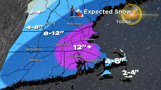
4-8"
Extreme western MA, southern Vermont, and the upper Cape and Vineyard.
2-4"
Outer Cape Cod and Nantucket (Due to mixing and rain issues), most of central and northern Vermont (due to lighter snow rates).
WINDS
The strongest winds will arrive late Thursday morning and last through the storm.
65-75 mph
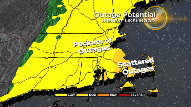
Cape Cod and the Islands. Power outages and widespread wind damage a certainty in this area.
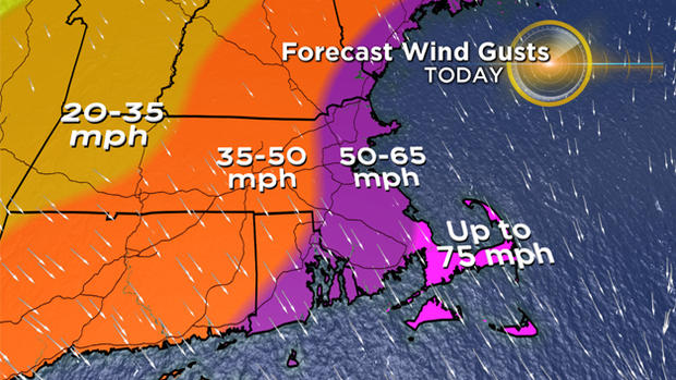
50-65 mph
Coastal Maine, New Hampshire and Massachusetts, all of southeastern MA. There is likely to be significant wind damage in these areas and perhaps a significant amount of power outages.
35-50 mph
Just inland from the coast, west of Route 128, back through Worcester county, large part of southern New Hampshire.
20-35 mph
Western MA, western New Hampshire and Vermont.
COASTAL FLOODING
With the full "wolf" moon just passing, not to mention it was a supermoon (closer than normal to Earth), our tides are running very high this week. Even without a storm, we would had seen some minor coastal flooding.
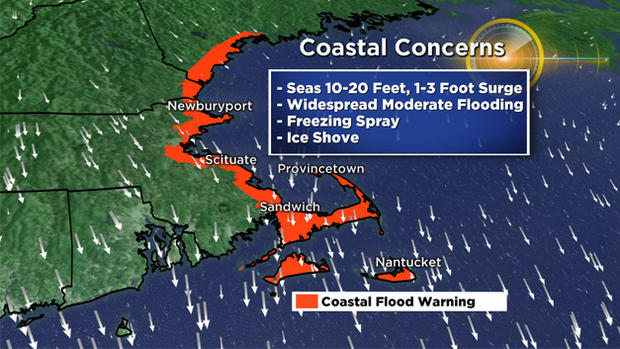
High tide on Thursday arrives just after noon in Boston. Widespread moderate with pockets of major coastal flooding is expected during that tide cycle. Thankfully, the storm is a fast mover.
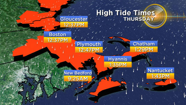
So, by the time of the next high tide (after midnight Thursday) winds will have shifted to the north-northwest, an offshore direction.
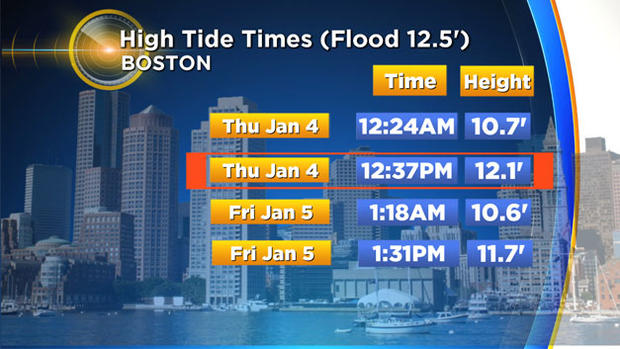
The vulnerable shore roads will likely all be washed out with some inundation up to 6 feet in low lying areas.
Storm Surge: Expected to be 2-to-2.5 feet north of Boston and 2.5-to-3 feet south of Boston (north and east facing shore).
Waves: The seas will build very quickly on Thursday and waves just offshore will reach 10-20 feet/ice shove. Perhaps a new term to many, an ice shove refers to the washing ashore of chunks of ice that have built up due to the cold weather. This is a real concern during this event.
Freezing spray: Another concern with the cold temperatures combined with the waves splashing over...some of the sea spray will freeze on contact with homes and structures.
WHAT'S NEXT?
If all that wind and snow wasn't enough, the cold that will follow this storm will likely be the harshest we have seen this year and perhaps for many years.
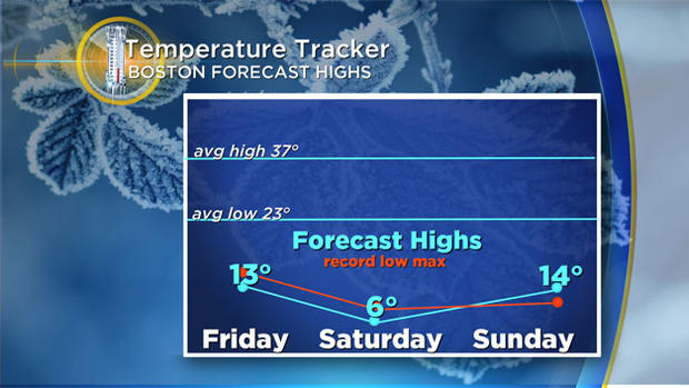
The low temperatures on Saturday and Sunday morning will likely shatter records (-10 to -20 or lower) in most of Boston's suburbs.
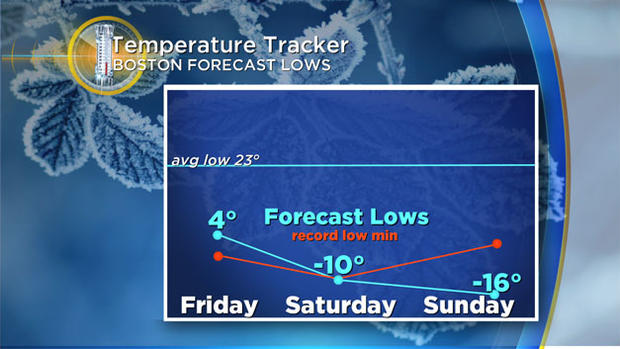
The City of Boston will also drop below zero, a very rare feat. High temperatures on Saturday will struggle to get above zero in Boston and in many suburbs stay below zero all day!
Needless to say if there are any lingering power outages from Thursday's storm that is going to cause a major problem.
We urge you to stay tuned to updates on WBZ-TV and CBSBoston.com. We'll have you covered every step of the way.
Stay Safe!
Follow Terry on Twitter @TerryWBZ


