Spring Nor'Easter To Bring Heavy Downpours
BOSTON (CBS) - A mini-nor'easter is on the way in the next 48 hours. Taken at face value, that may sound a bit depressing but I would contend that for the most part, this is actually a GOOD thing! After all, April showers do bring May flowers right? With our region teetering on the brink of recovering from a several year long drought we need the rain to keep coming. A couple of wet months has temporarily refilled many of our rivers and reservoirs, but remember that we are still more than 25" below the average for the last 5 years. So, what is truly needed, is an average to above average spring and summer of rain. After a very wet start to April, the last 2-3 weeks has been quite dry. Most areas have received less than an inch of water in the time frame. If that trend had continued into May, the drought concerns would have undoubtedly returned. So, a couple days of rain and a few inches of water from that standpoint is a very good thing.
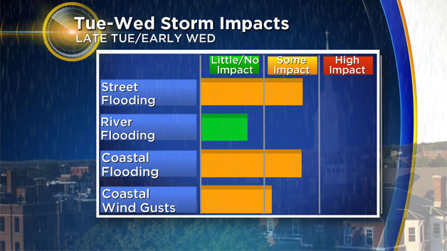
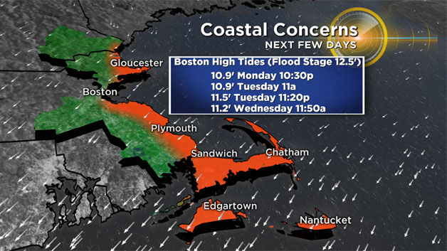
Of course, if you have outdoor plans in the next couple days you may not be so understanding. Not to mention, this storm is coming at an inopportune time with respect to the tide cycle. Remember the "King Tides" that were in the news last year? Well, they're back this week. King tides are nothing new, but instead refer to the handful of highest astronomical tides of the year. This week, tides levels in Boston will climb over 12 feet (flood stage being 12.5') without any help from the weather. Combine those tides with a mini-nor'easter featuring a couple days of onshore winds and you have a recipe for at least some minor flooding in your typical, vulnerable shore roads.
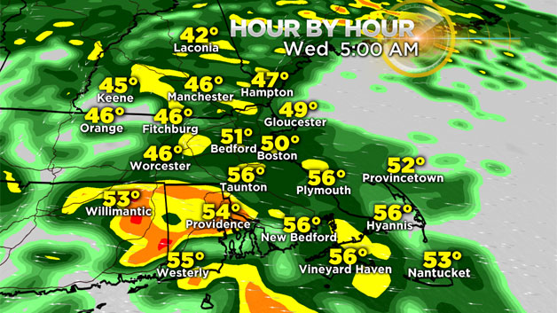
RAIN TIMELINE:
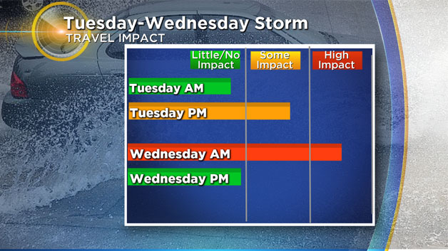
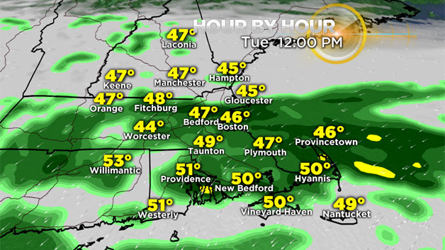
The rain will arrive Tuesday morning, rotating into Southern New England from south to north. By midday most of the area should see some rain of varying intensity. The heaviest rain arrives Tuesday night and particularly Wednesday morning. The commutes will be slow going with some ponding on the roadways and periods of heavy downpours. The entire area should receive between 1-2" of rain in this time frame. This will not be enough to spur any major river flooding, but some smaller streams could rise to their banks. Rain tapers to showers later Wednesday and to pockets of drizzle overnight into early Thursday morning.
COASTAL CONCERNS:
The best chance of coastal flooding will coincide with the peak of the storm later Tuesday and into Wednesday. High tide times will be right around Midnight and Midday Tuesday and Wednesday and with just a small storm surge of a foot or so there will be some minor flooding along the east facing shoreline. Astronomical tides actually peak later in the week (Thursday-Friday), reaching some of the highest levels of the year. Thankfully, winds will be weaker on Thursday and eventually turning to a more southerly direction by Friday. Still, something to keep an eye on with levels being so high.
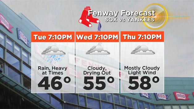
Headed to the Sox? Big series with the Yankees this week…Tuesday will be the best chance of a delay or washout, slightly less miserable weather for Wednesday and Thursday evenings games.
Finally, this is a great time to thrown down some grass seed or fertilizer! While temperatures are not quite ideal yet, with a couple inches of rain coming followed by what looks like a warm period later this week and into the weekend it is time to start thinking about your lawn again! Gas up the lawnmower!