New Month, More Snow? Cold Nor'easter Kicks Off April
Find Eric Fisher on Twitter and Facebook
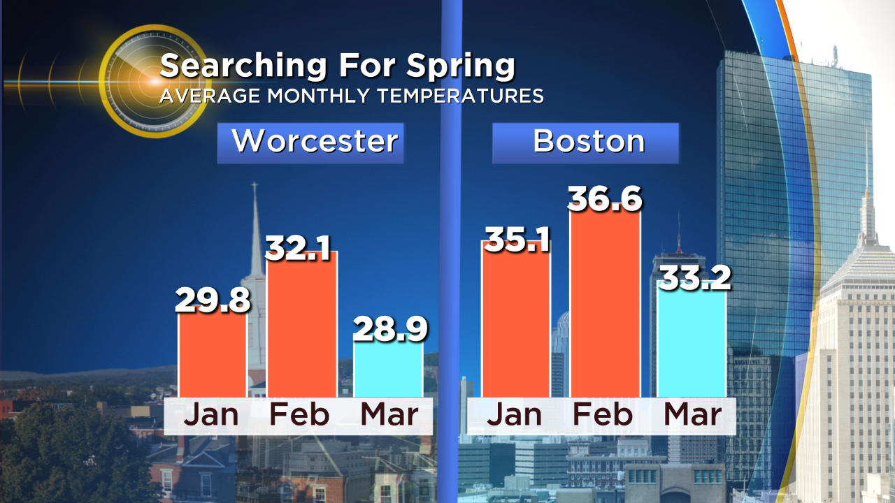
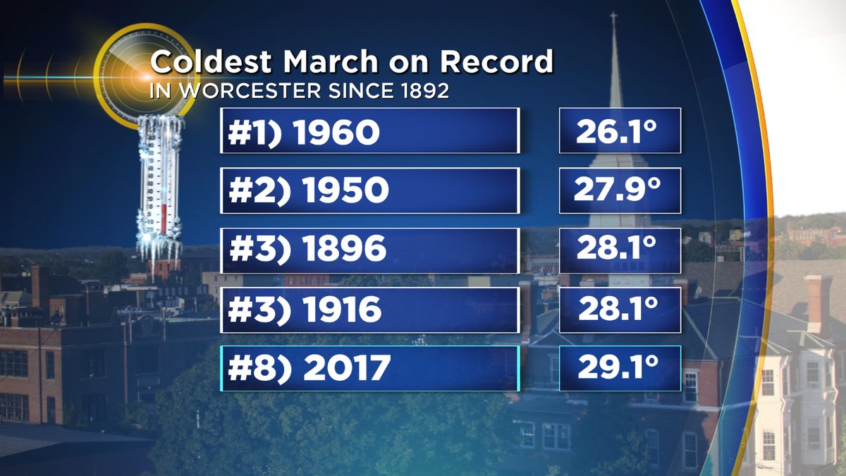
It's not just you, this month has been cold. Really cold. How cold, exactly? Well it'll be the first month of below average temperatures in the Boston area since last April, which perhaps isn't saying much. But in Worcester we're on pace for what should be the 11th or 12th coldest March on record. Not record breaking, but impressive in a warming climate. Most all of our cold records are from decades ago. When we even get close or sniff one these days, it's worth noting. On top of that, it's likely to end up the coldest month of the whole cold season! The average monthly temperature for March is colder than December, January, or February. For parts of southern New England, that's never happened before dating back to the late 1800s. Extreme warmth in January and February helped the cause, but this month has been impressive in its own right. Wouldn't you know it - New England is one of the only colder than average spots in the country this March. Lucky us!
So what's next? More cold! And perhaps more snow and ice to boot. The storm system producing severe weather in the middle of the country will slowly roll our way this week, eventually interacting with some northern jet stream energy and intensifying off our coastline. It has all the makings of a very tricky forecast that's sure to shift some in the days ahead, but here's a look at the current players and what I'm thinking.
First up, let's address the question of whether daytime snow can easily accumulate in late March/early April. The answer is yes, but under the right conditions. You need either exceptional cold for the time of year (like we had the first week of April in 2016) or heavy snowfall rates. At this point, I don't think Friday is going to offer either. Departing high pressure will leave some cold in place, but it's marginal cold. Daytime temps should reach the mid and upper 30s on Friday, so even with a cold air mass aloft and some snow/sleet falling, it will likely have a tough time adding up on the roads/pavement. A wintry and ugly day is expected, but probably not any major issues when it comes to travel, flights, etc so long as surfaces are treated. It looks like that wintry mix should arrive sometime in the morning, particularly for areas of western New England.
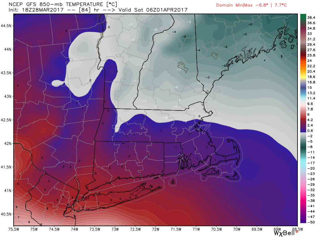
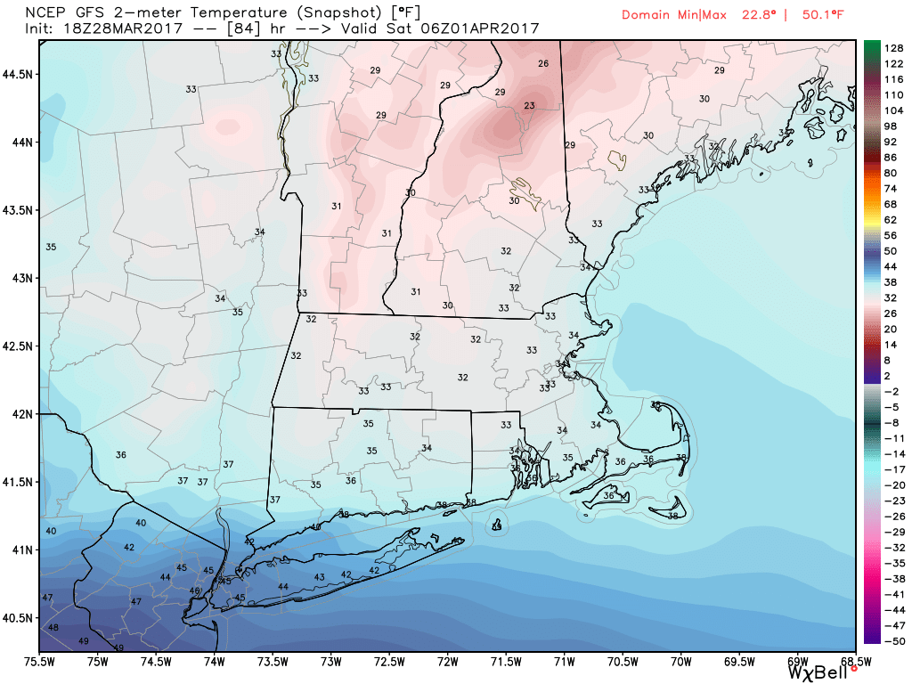
A look at temperatures (in ºC) at 850mb, and at the surface (ºF). We'll be riding the freezing line through thousands of feet of the atmosphere during this one.
I think that it will be as the sun sets Friday that things will have the potential to get interesting. The biggest issue at hand is the thermal profile of the atmosphere, which is going to be borderline to say the least. From the surface upward thousands of feet, temperatures should be very close to the freezing mark. An onshore flow out of the east is likely at the surface, but this time of year the ocean has its weakest influence on winter storms. We've bottomed out with water temps in the upper 30s to low 40s, so only slightly moderation of air temperature takes place. This may save the immediate coastline and southeastern Massachusetts from any significant snowfall or ice, but it won't penetrate inland much. Aloft, warmer air will be trying to force its way in. How far north will it get? That's the biggest question mark. The farther north it goes, the more of our area changes over to sleet and rain instead of snow, limiting impact.
Without any solar heating, the night offers our best chance for accumulation. It also so happens that the heaviest precipitation should be arriving overnight into Saturday morning. So we have all these competing forces. You have warmer air trying to move in aloft, changes in daylight, changes in intensity (more intense lends itself to more cooling/snow), and onshore winds dragging slightly milder temperatures in off the ocean. The result hinges on how all these play together.
Sitting here several days out, here's how I see it. Friday brings a mix of snow/rain/ice but most of it is nuisance variety more than high impact weather. So long as roads are treated where temperatures are near freezing, it should be a manageable yet ugly day. Highs will reach the mid and upper 30s, so any snow will be very wet and heavy in nature and have difficulty adding up on pavement.
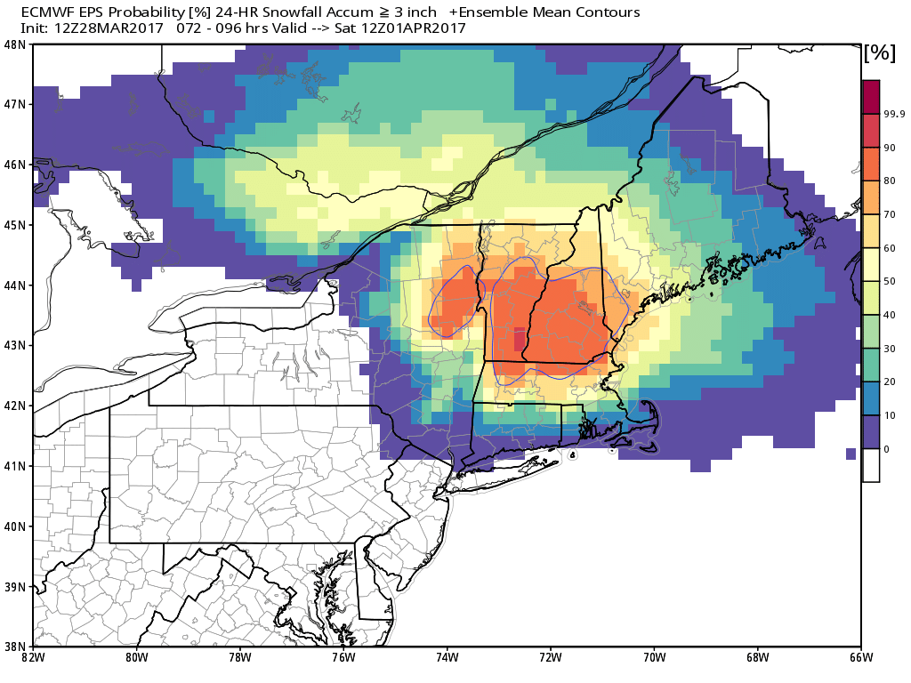
Euro EPS showing the probability of >3" of snow Friday through Saturday. Just a tool to help showcase where odds are highest!
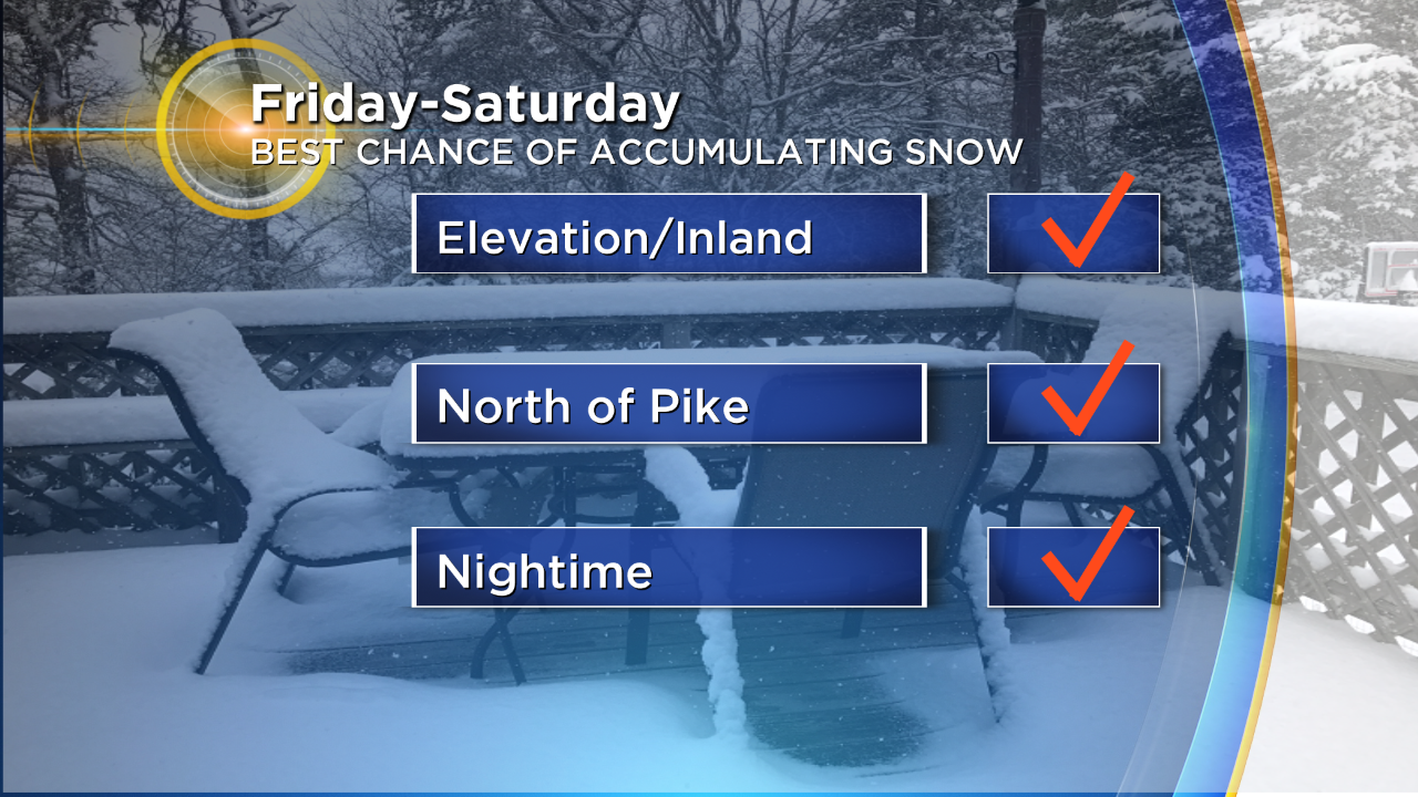
Friday night is the main part of the storm to watch. As it intensifies south of New England, heavier precipitation will be likely. This is where the potential for heavy wet snow goes up for interior areas. I'd favor the Berkshires, northern Worcester County, the Monadnock Region, and central New England for the highest snow odds. Essentially, inland and with elevation. Mixing with sleet or freezing rain will also be a possibility for these locations. While snowfall is possible in Metro Boston and even areas south of the Pike, I think it would end up being more of a 'ugh, more snow' situation than a heavy accumulation situation.
Saturday morning the heavy precipitation will begin to taper down, but still with some rain/snow showers lingering into the afternoon.
**Note of warning: Beware model snowfall maps these next few days! They are assuredly going to be wrong, because they mix in sleet/ice as snowfall and we also won't be working with a 10:1 ratio. We'll lose a lot of accumulation to mixing, the wet snow type, and 'wasted' accumulation during the daylight hours where it won't add up much. This a situation where they should end up being particularly misleading.
Main Concerns
- Power outages: We would need to pick up 6"+ of wet snow to really get into power outage range and that's no slam dunk right now. This far out, I think the odds for this to happen are highest across northern Worcester County northward to central New England.
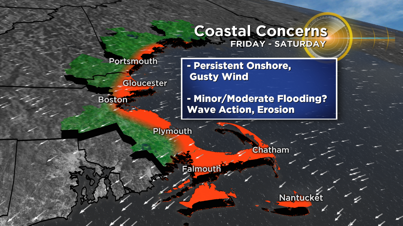
2. Coastal Flooding: Onshore winds look likely Friday into Saturday, so we'll build up water over a couple of high tide cycles. It won't take much to produce minor to moderate coastal flooding because astronomical tides are quite high, especially early Saturday morning. Rough surf and gusty winds will come along with that, with some guidance suggesting 50mph gusts could be possible for coastal southeastern Massachusetts.
3. Icy/snowy travel: Again I think this will be manageable Friday, but it could get pretty nasty in parts of the area Friday night into Saturday morning.