Active Weather Pattern Brings Three Chances For Snow In Upcoming Days
By Terry Eliasen, Meteorologist, WBZ-TV Exec. Weather Producer
BOSTON (CBS) – Not 1… Not 2… But 3 chances at SNOW in the next seven days! No, winter ain't over yet, not even close.
After several record warm days in the last couple weeks, numerous cases of spring fever were breaking out all over New England. Crocuses were starting to emerge, the last of the snow had long since melted and many were wondering if maybe, just maybe, old man winter had packed his things early this year. Turns out, he was just taking a late February nap.
The record cold last weekend was just the start. After a brief warmup Wednesday, we are headed back for the deep freeze again this weekend. In fact, there is a solid chance that we may reach new record low maximum temperatures on Saturday and even get close to some record low minimum temperatures early on Sunday!
This time around though, the cold surge arrives along with an active and stormy pattern across the Country. Several waves of low pressure will ripple along a boundary in the northern tier of the United States in the next 7-10 days. This boundary is actually quite typical this time of year as warmer air starts to push northward in early spring, clashing with the cold already in place.
The question now is where exactly does that boundary (storm track) set up and how much will we be affected here in Southern New England.
Let's look at each potential event one by one.
Storm 1 - Friday
Friday's storm is initially a weak wave forming along a cold front just to our south. It will start to feed off that clash of airmasses as it slides quickly east through the Ohio Valley late on Thursday. A relatively small band of moderate snowfall will form, likely only a few hundred miles wide, but those who end up underneath this band will receive a quick shot of plowable snow.
Initially, most models put the bullseye just to our south…through parts of Pennsylvania across to the Mid Atlantic, just brushing our South Coast with a light accumulation. Now it appears as though this band of snow will push a bit farther north, bringing most if not all of Southern New England into the game.
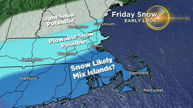
Time to watch would be Friday morning (about 8 a.m.) through Friday afternoon. Worst-case scenario would be a widespread, plowable snowfall, perhaps something on the order of 3-6 inches. But the exact location of this thin band still remains somewhat uncertain. There is still a decent shot that the heaviest snow will stay to our south and we get nothing more than a dusting to an inch or two south of Boston.
Storm 2 - Late Sunday
A fairly potent storm will dive out of the Pacific Northwest early this weekend, dig into the deep south Saturday night and then make a turn northward on Sunday. Right now it appears as though the high pressure and cold air pouring into the Northeast will be so strong this weekend that it will push the storm out to sea, far to our south.
However, given that this event is still several days away, there is plenty of room for an adjustment in track. Should this storm find a way to steer farther north and up the Coast to New England, it would likely be a much larger blow than the Friday storm.
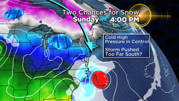
Picture more of a nor'easter-type event with wind and potentially high amounts of snow. Again, right now, odds favor a miss to our south, but the timeframe between Sunday PM and Monday AM is one to keep an eye on.
Storm 3 - Early Next Week
Right on the heels of the Sunday storm comes yet another wave out of the Pacific Northwest. Of course, it is way too early for serious speculation on this one, but early indications are for a more northerly storm track than storm #2 and therefore a more likely impact of some sort here in New England. Timeframe to watch here would be late Monday through Tuesday and it does appear as though enough cold air would still be around for some snow accumulation IF this storm were to come to fruition.
Long story short, winter isn't going out without a fight. While no one of these storms is near a lock just yet, there are enough chances in the pipeline right now to nearly assure us that we have NOT seen our last snow accumulation in Boston.
As always, stay tuned to WBZ-TV and CBSBoston.com for frequent updates.
Follow Terry on Twitter @TerryWBZ


