Record Warmth Dominates The Lower 48
Find Eric Fisher on Twitter and Facebook
We had a solid stretch for the snow lovin' crew, but it was not meant to last. We've watched our snowpack rapidly melt with a full-on retreat coming over the next few days. By Saturday, snow cover will be a memory for most of southern New England and the inbox here at WBZ will be full of crocus and witch hazel photos. The remarkable spring warmth that has dominated most of the country this month is about to move in.
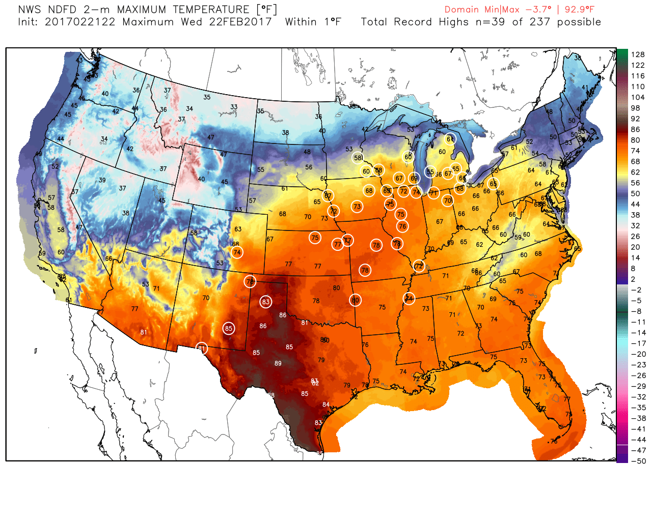
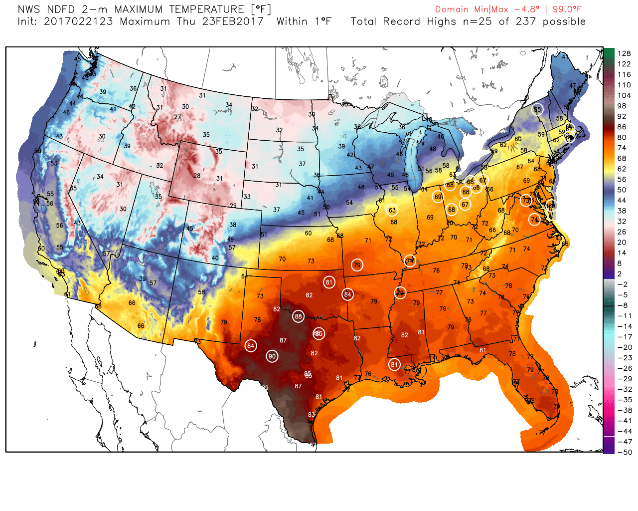
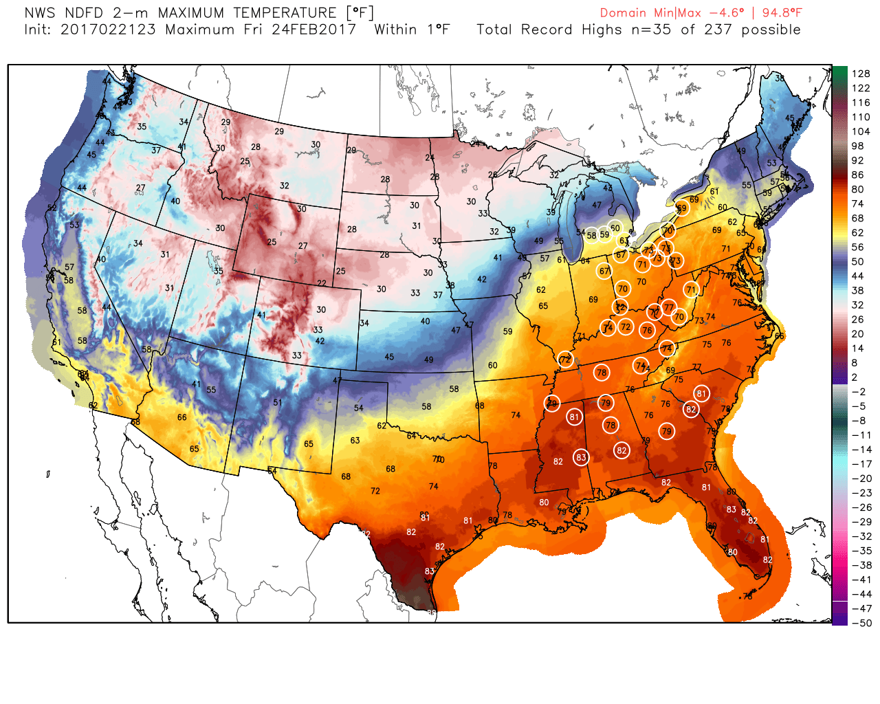
Dozens more record highs are expected to be set Wednesday through Friday across the east with widespread 70s and 80s. A far cry from typical February conditions. Source: Weatherbell
There are some truly incredible stats coming out of the Midwest during this warm spell. Chicago is about to top 60F for the 6th straight day (Wednesday), breaking an all-time February record. In the process, it may also see the warmest winter temperature on record in the city, which is 75F. Minneapolis has only reached the 60s in February six times in the past 144 years, and 2 of those have been this week. They'll be close again Wednesday. To the south, Atlanta has topped 70 degrees 18 times so far this year. That would be, you guessed it, the most on record to date. The next three are all expected to top 70F as well. Spring blooms and foliage are running about 3 weeks earlier than normal across nearly all of the south. And in DC, they're likely looking at one of the earliest cherry blossom blooms on record. A pink tinge is already showing up along the tidewater and a mid-March show looks increasingly likely.
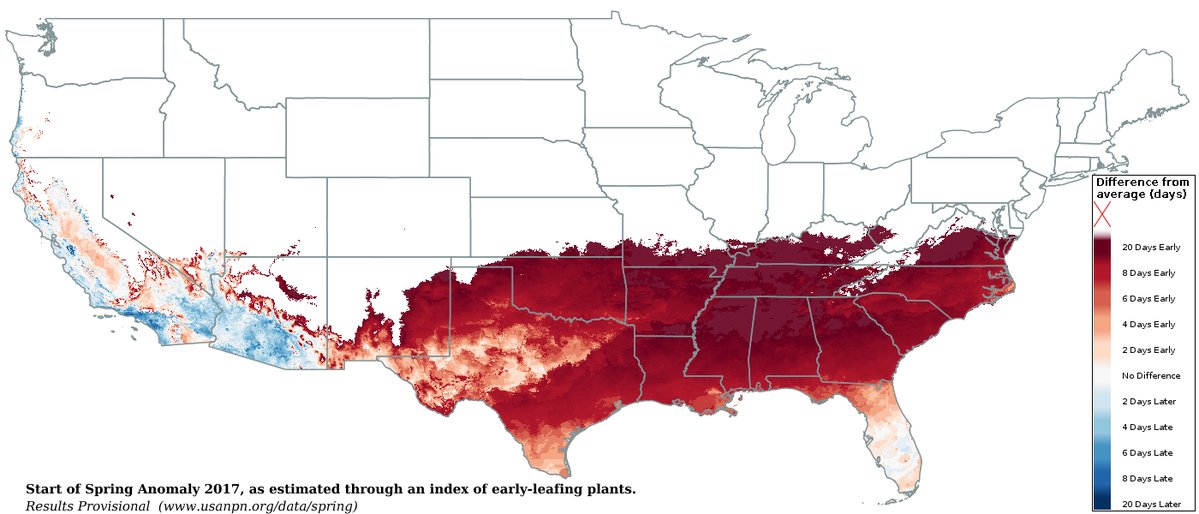
Leaf-out is occurring across a wide swath of the south with early cherry blossoms already blooming up to Virginia. Source: https://www.usanpn.org/data/spring
How does this compare as a whole? The incredible streak of warmth has pushed us to within shouting distance of the warmest February on record for the Lower 48, which currently is held by 1954. The average CONUS temperature was 41.4ºF that year, and through Monday has been 40.1ºF this year. Considering the huge areas of well above average temperatures coming in the days ahead, there is a good likelihood 2017 will take the top spot. Also likely that every single state will have seen above average temperatures in February with perhaps the exception of Washington.
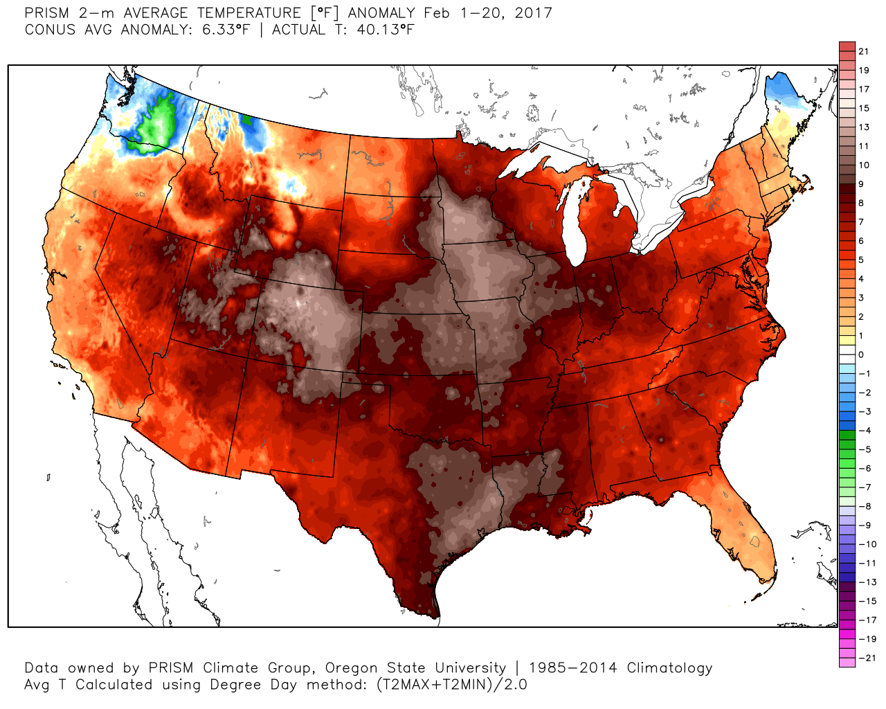
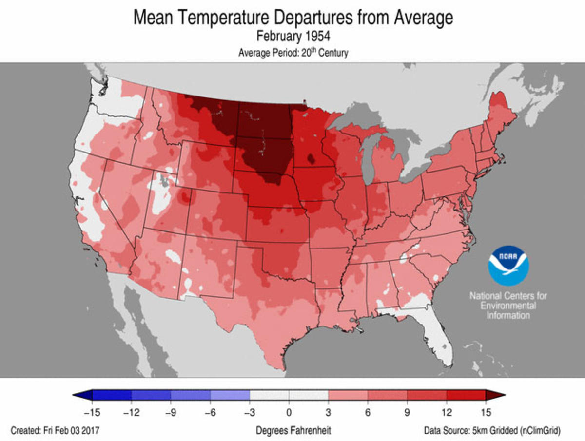
Temperature anomalies through February 20th versus the warmest February on record, 1954. Source: NOAA
All of this is particularly notable because we A) had a La Nina winter, albeit a weak La Nina and B) there was a huge run-up of cold and snow across Siberia last autumn. Both of those variables should have allowed for colder times this winter. As you'd imagine, climate change loads the odds in favor of warm to begin with. It's almost getting to the point where it seems foolish to even predict below average months unless there is a *glaring* signal for it, a la 2015 for us. Even with La Nina, the globe is running +0.45ºC for the year with the biggest warmth across China, North America, and the Arctic. Signs are pointing to a possible El Nino return by this summer which would keep the global warmth coming.
How about here in New England? Well up to this point, it had been a pretty typical February. But this final week of temperatures is going to put us well into the red and even bring some climate sites into a Top 5 warmest winter on record (Burlington, VT is currently at #3). The city of Boston will notch its 10th straight month above average, making it 19 out of the past 20 to do so.
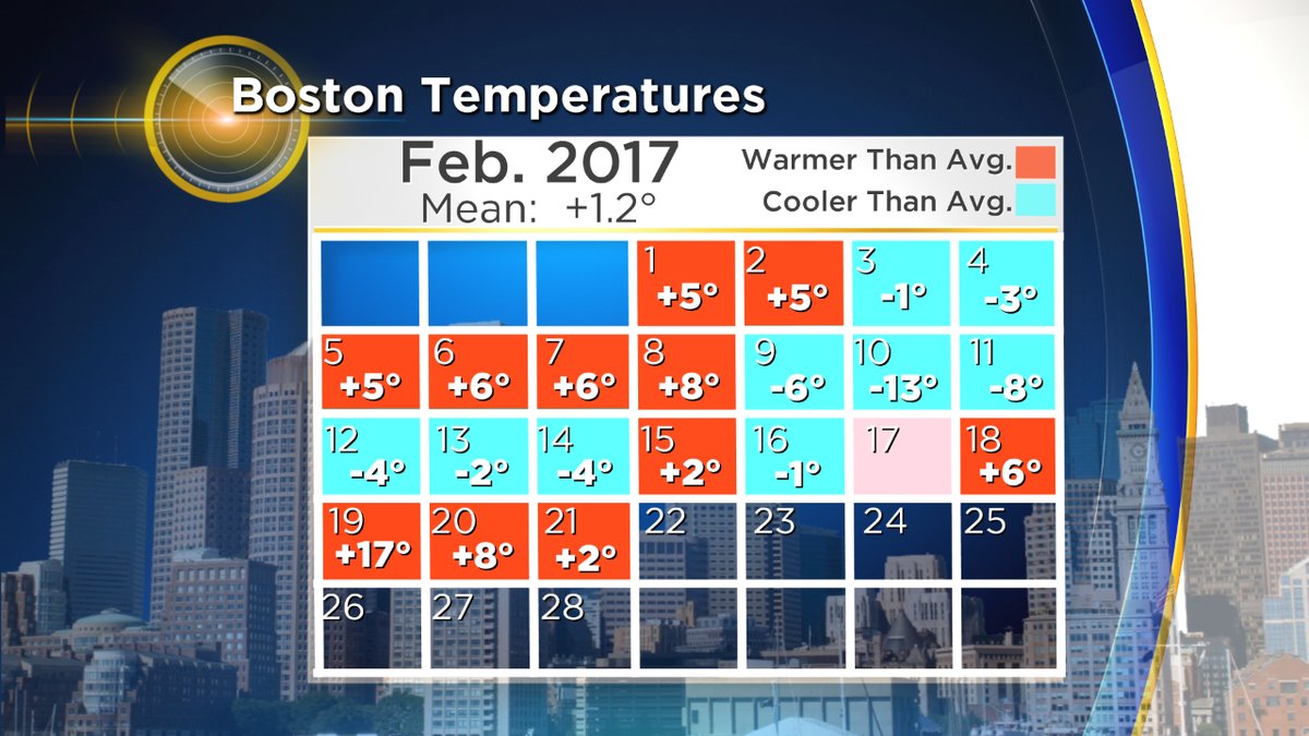
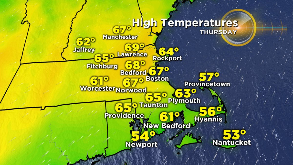
While Wednesday will bring in the mild 50s, Thursday brings the best odds of record-breaking temps in southern New England. Boston's record is 65F, and the current forecast calls for 67F. It'll be highly dependent on wind - we'll need it to stay southwesterly instead of southeasterly, which would bring in colder air off the Atlantic. But I'd say there's a good shot. The warmest temperatures overall should be focused from MetroWest up through the Merrimack Valley. IF we get enough sunshine, I wouldn't say it's out of the question that some towns could hit 70F. It should be noted that Boston has only seen 70 degrees once during February, dating back to 1872. If we somehow overachieve, it would no doubt be rare air. As you'd imagine with temperatures like these, what's left of the snow cover will be disappearing in a hurry Thursday.
While a backdoor front may cool us off a bit Friday, a surge of 60s is likely to return on Saturday. It may even feel a little humid outside as dew points climb well up into the 50s. To cap it all off, a late afternoon/evening cold front could bring rumbles of thunder along with gusty winds and scattered downpours. Even the 'big cool down' for Sunday really isn't much to write home about. Most will still see high temps 40-45, which is just a return to average readings for late February.
Will the mild trend continue? I'd say yes. Guidance points to the extremely resilient southeast ridge to keep building back in over the next couple of weeks. This ridge promotes 'inside runner' storms that track to our west, and keep the eastern U.S. very mild. So at this point I'd expect a much warmer than average March here in New England. It should be pointed out that you don't need colder than average temperatures to get snowfall in March. However, the predominant storm track is not overly encouraging for snow lovers. We seem to be on a course for early spring, and can only hope that we don't have another ill-timed freeze when our fruit trees bloom. While mild temperatures may be great to enjoy outdoors, they pose the risk of killing off or damaging plants when typical early spring cold swings through. Something to keep an eye on in March and April.
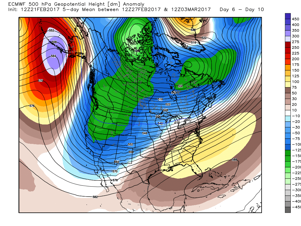
The ridge that refuses to give up. It's been hanging on for the better part of a year now! Courtesy: Weatherbell