Weather Alert: 'Kitchen Sink Storm' Arriving
BOSTON (CBS) -- Slop. Slush. Cement. We call these types of events "kitchen sink storms," because we are going to see just about every precipitation type in Southern New England over the next 12-24 hours…in other words "everything but the kitchen sink."
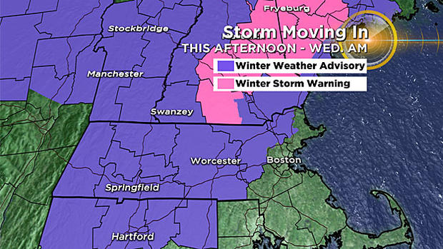
Remember that storm about 10 days ago? A nice, fluffy, easily-moved snowfall for just about our entire area. Well, this will be exactly the opposite. This storm will feature a very heavy, wet snowfall for areas well to the north and west of Boston.
Closer to 495 and 128, the precipitation will be flip-flopping between a wet snow, sleet pellets and even rain at times. Those locations which saw the snow jackpot back in early January, including Boston and mainly areas to the south, will see mainly rain this go around.
TIMELINE:
Through 7pm: Conditions at the ground level are warm at the onset of the precipitation, so it will start as rain in most locations during the early evening commute. As the precipitation continues and comes down heavier, temperatures will quickly cool and a relatively rapid change to wet snow will occur in most areas north of the Mass Pike, perhaps even in Boston for a short time. By 7pm, we are well underway and snow may already be sticking to roadways north and west of the City.
7pm – 11pm: Steady precipitation during this time frame…mainly rain in Boston and points south of the Pike, all snow north and west of 495, and a mix of just about everything between 128 and 495. Several inches of snow will accumulate in Northern Worcester County, far Western Middlesex county and in Southern New Hampshire away from the Coast. A potpourri of precipitation types (snow, sleet and rain) expected in places like Haverhill, Lawrence, Lowell, Marlboro, Burlington and Woburn (128 to 495).
Overnight: More of the same…steady snow in Northern Worcester County and most areas north and west of 495. A sloppy mix north of the Pike and around the 495 belt. Mainly rain along the Coast including Boston and all areas south.
Wednesday Morning: After dawn, the precipitation will gradually slow down and taper in spots. Most snow and ice accumulation will be done between 7am and 9am. Plan for extra time for the AM commute, especially areas north and west of Boston. There will likely be several school delays and some cancellations in the locations in the snow and sleet belt. While the steady and heavy precipitation will taper during Wednesday morning, pockets of flurries and drizzle will continue most of the day and a steady and gusty onshore wind will make it a very raw, nasty day.
HOW MUCH:
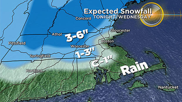
3"-6" of heavy, wet snow: northern Worcester County (hills) into southwestern New Hampshire and up through the ski areas.
1"-3" of heavy, wet snow mixed with sleet and some rain: 128 to 495 north and west of Boston and away from the coastline.
Coating to a sloppy inch: scattered around in the immediate suburbs of Boston, around and just inside 128.
Nada: just rain east of I-95, all of southeast MA, Cape Cod and Islands
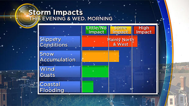
WIND/COAST:
No wind damage expected with this storm but a persistent, gusty north-northeast wind is expected along the immediate Coastline all the way from the North Shore through Boston and down to the Cape. Winds will average 15-30 mph with gusts to around 35 mph at times. No coastal flooding expected.
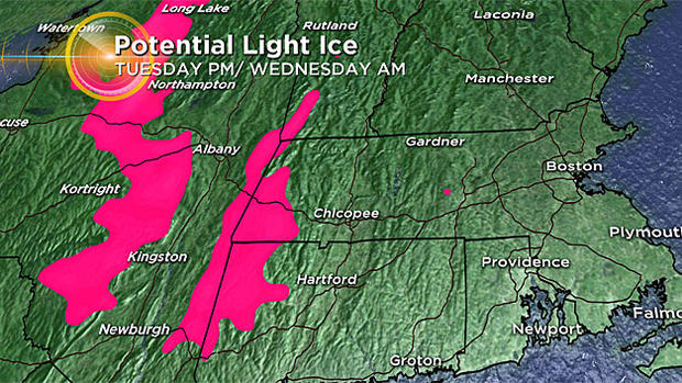
This will NOT be an "ice storm." There may be some light ice accretion in Western MA (Berkshires), but we are not forecasting much freezing rain with this event locally. Sleet is very different from freezing rain in the fact that it falls as small "ice balls" and can accumulate much like snow does. Sleet does not stick to or freeze on contact with surfaces like freezing rain. The primary threat with this storm will be hazardous travel associated with snow and sleet accumulation late tonight and early on Wednesday.
Temperatures at ground level will be extremely "borderline" for a good portion of our area throughout the duration of this event. A slight increase or decrease of just a degree or two can and will mean the difference between extremely hazardous travel and just plain rain. As always, we urge that you stay tuned to WBZ-TV and CBSBoston.com for frequent updates through Wednesday morning.