Significant Snow And Blizzard Conditions Saturday
BOSTON (CBS) - Ding, ding! Round 2 is moving in after an appetizer snowfall fell Friday morning. The main course is up next and should pack quite a punch.
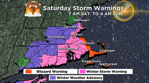
This much more significant winter storm will bring hefty snow and strong coastal winds Saturday, with the highest totals affecting towns near and south of Boston. A shift to the west over the past 24 hours has brought snow amounts up along with it. More towns to the west are now expected to see snowfall as well, all the way to western Massachusetts. In addition, the National Weather Service has issued Blizzard Warnings along the coast from the South Shore to Cape Cod and the Islands. This is where winds are expected to consistently top 35mph and produce visibility under 1/4 mile Saturday afternoon and evening.
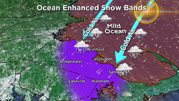
We are now forecasting a large area of 8-14" of snow for all of southeastern Massachusetts, the city of Boston, and the immediate North Shore to Cape Ann. In fact, there may be some locally higher amounts along the South Shore and Plymouth County due to some ocean enhancement within the bands of snow. Would not be shocked to see 18" or a bit more in some highly localized snow bands, particularly in a zone from Scituate to Sandwich and southwestward to the Wareham area.
In Boston we expect around 8" of snowfall, give or take a few inches on either side.
Areas just north and west of Boston, up to 495, we are forecasting 4-8".
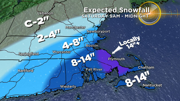
Farther north and west, well beyond 495, snow amounts drop off dramatically. Two to 4" in northwestern Worcester County and southwestern New Hampshire and just a coating to a couple inches beyond there toward North Conway and west to southern Vermont.
This is a cold storm, with daytime highs stuck in the 20s for most of the region and falling into the 10s by evening. Which means that instead of liquid cement, this snow will be light and fluffy. Easy to move and easy to accumulate, but also easy to blow around. That means poor visibility at times and drifting snow will be likely.
Timing:
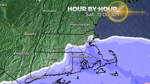
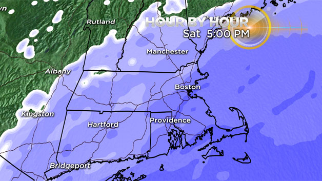
Coastal snow showers will develop by mid-morning as an onshore flow creates ocean-effect snow for the South Shore, Cape, and Islands. But the heaviest snow and majority of accumulation occurs from Noon to 11 p.m. on Saturday. Near whiteout conditions at times along the Coast Saturday p.m. with northeast winds gusting over 40 mph and snow coming down hard. If you have to travel and want to avoid the deteriorating conditions, the early morning will be best. Most of us should be seeing snow by midday.
Snow will be fluffy and relatively easy to handle in most areas, however that also allows it to stack up much quicker. Bit more heavy/wet towards the Outer Cape and Islands where temps will hover 30-33F. The wettest snow of all will be found on Nantucket (also the mildest temps).
Winds:
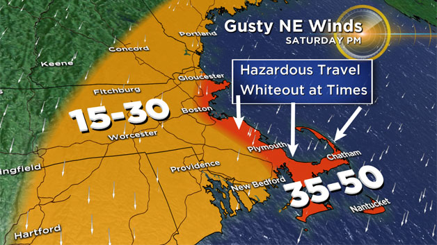
Northeast wind gusts 15-35mph through the storm for most inland areas. Winds will be strongest along the Coastline and especially over the Cape. Winds there could gust 40-50 mph Saturday afternoon and evening. Not enough for widespread power outages, thankfully. But enough to produce lots of drifting snow.
Coastal flooding is NOT a concern as tides are astronomically low. High tide occurs just after 6 p.m., but we are not expecting any significant splash-over or flooding.
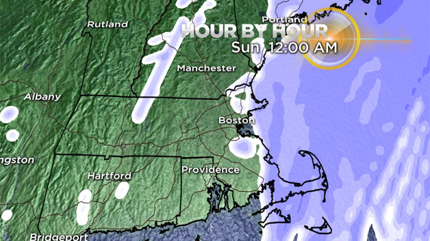
While most of the region sees snow tapering off by midnight, ocean-effect snow showers should linger in Plymouth County and across Cape Cod well into the night, eventually giving up by Sunday morning. So some additional overnight accumulation is likely, even as the steadiest snowfall moves offshore.
This fresh snowpack will also make for a frigid end to the weekend and start to next week. Highs will stay in the upper teens to low 20s on Sunday, and a gusty breeze will make it feel more like the single digits. Then as winds calm Sunday night, temperatures should plummet. A few towns will go subzero by Monday morning, with the rest of the region a few degrees above zero. Even with bright Monday skies, highs will struggle to reach 20 degrees. It won't last for too long however, as a mild rain will develop by Wednesday!
Stay tuned for further updates on WBZ-TV and CBSBoston.com.