Frigid Facts: What You Need To Know For Dangerously Cold Weather
BOSTON (CBS) - The Arctic doors have burst open and the Polar Express is headed straight for New England! Call it what you want, bone-chilling, frigid, an Arctic blast, bottom line: the next 24 hours are going to be downright dangerously cold.
Here is what you need to know, the frigid facts:
WINDS
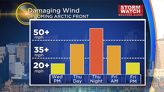
Wind gusts during the day Thursday will average 20-to-40 mph across the entire region. High wind warnings are in effect overnight tonight when winds will be at their peak. Widespread wind gusts between 25-50 mph are expected throughout all of New England tonight. Gusts up to 60 mph or perhaps even 70 mph are possible in elevated areas (Worcester Hills and Berkshires) and also over Cape Cod and the Islands.
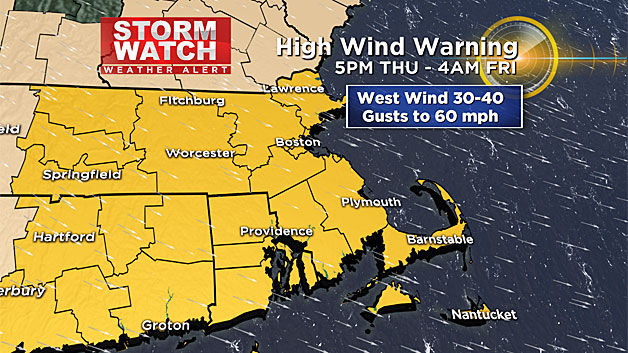
By Friday morning winds will "weaken" back down to a more reasonable 20-40 mph and continue to drop through the day, hardly noticeable by Friday evening.
WHAT COULD THIS MEAN
This will certainly lead to pockets of wind damage and some downed power lines.
Scattered outages means that some homes could be left without heat, on perhaps one of the coldest nights of the season. Got a generator? Make sure it is in a safe place and well ventilated.
Don't forget your Christmas decorations! Got an inflatable Santa or Frosty? Deflate and bring inside! Unless you want to give your neighbors down the street an early Christmas gift. The lights on the trees and bushes are likely safe, just be sure that they are well fastened to the limbs and not loose.
TEMPERATURES
While it won't challenge the coldest readings on record for the month of December, we could challenge some daily low records in our region.
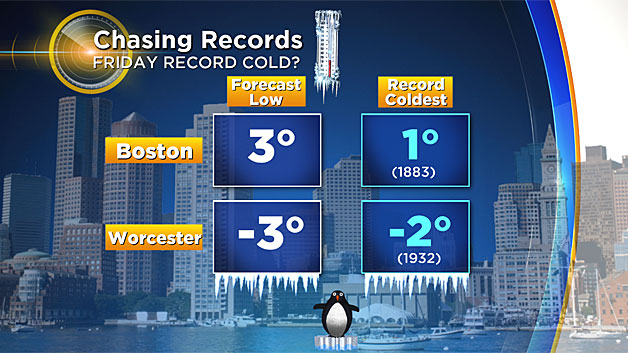
Boston's record low Friday of 1 degree set back in 1883 is likely safe, however there is a good chance that Worcester will set a new record low - currently we are forecasting -3 (the record is -2 set in 1932). Friday will be one of those "ineffective sunshine" days. We get a handful of days each winter when even though the sun may be shining brightly, it has little effect. High temperatures Friday will be in the teens, again challenging records for the lowest maximum temperature for the date in Boston and Worcester.
WHAT THIS COULD MEAN
Temperatures this cold can have ill effects on people, pets and vehicles!
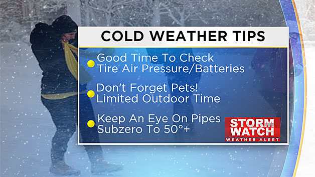
Remember your furry friends, limit their time outdoors. Check on your neighbors and the elderly to be sure they have heat. This is a good time to check the air pressure in your tires and perhaps get that new battery for your car. An emergency kit in the trunk is also a good idea.
Read: Preventing and Thawing Frozen Pipes
Finally, keep an eye on your pipes, going from subzero on Friday to 50+ on Sunday is classic pipe bursting weather.
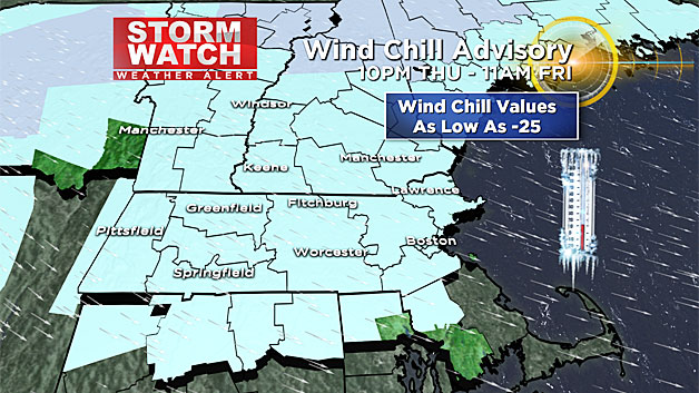
WIND CHILL
The feels-like readings Thursday night and Friday morning will be downright nasty.
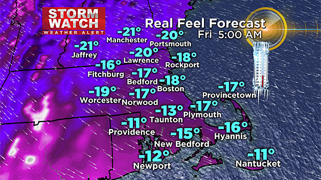
Wind chill values will range from a few degrees below zero down to -25.
WHAT THIS COULD MEAN
Under conditions like these, frostbite can occur in just 30 minutes.
The most susceptible parts of the body include; fingers, toes, ears and nose.
Read: Signs Of Hypothermia
Cover all exposed skin when going outdoors. Some schools may choose to close Friday due to the cold.
Check: School Closings
Consider driving your child to school or waiting in the car with them at the bus stop. The best way to avoid frostbite or hypothermia is of course to stay indoors. If you must go out, dress in layers of loose-fitting, lightweight, warm clothing. Wear a hat as much of your body's heat will be lost through your head.
So clearly the message here would be to be cautious and use common sense. If at all possible, avoid going outdoors for any prolonged periods in the next 24 hours.
This is a fairly brief Arctic outbreak, conditions will improve during the day on Friday and believe it or not temperatures may top 50 by Sunday. This is likely the last dangerously cold day for a while. The long range forecasts favor a warming trend by later next week and possibly through the end of the month.
Follow Terry on Twitter @TerryWBZ