Anniversary Of A Milestone - 100 Inches Then, 60's Now
On this date last year? Grumbling. Maybe outright snow rage. An icy landscape that stretched out in all directions.
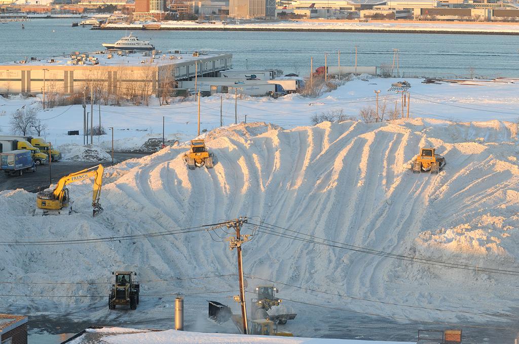
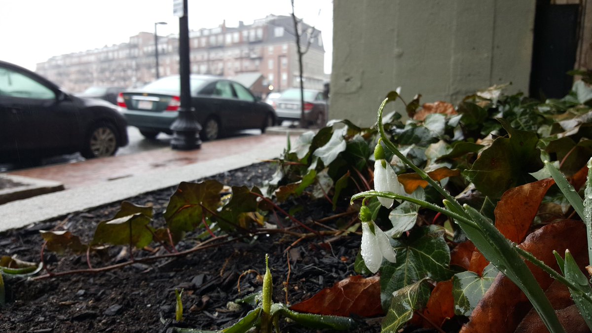
The Southie Snow Farm in February of 2015, and the only snow I can find in Boston right now - snowdrops blooming!
February 25th, 2015 brought us over the century mark for snow in Boston. It was a minor event, just 1.9" during the day.
But at this point people were starting to point blow torches at any dendrite which dared fall from a cloud. How far we've come from that epic winter blitz. Today we stand in shorts, 60s for some, with a nearly 100% snowless southern New England. Let's take a look at how starkly different life is between now and then.
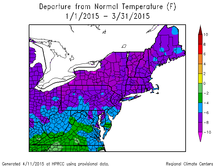
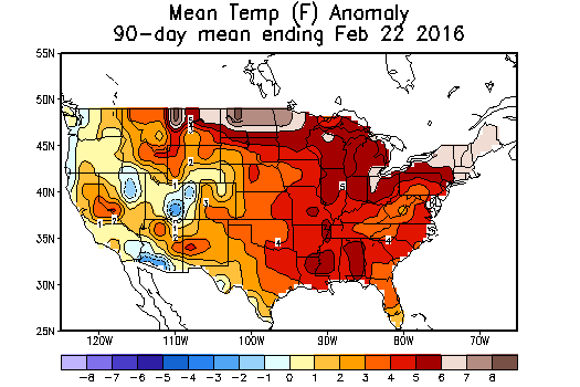
For much of the Northeast, January-March 2015 was the coldest such period on record. Source: Northeast Regional Climate Center
For starters, there's the extreme (and extreme is not hyperbole here) flip in temperatures. Last January through March was the coldest such period on record across New England. A constant feed of frigid polar air was unrelenting. The warmest February day in Boston failed to even hit 40 degrees (39F). In fact, 22 (!!) days couldn't even reach the freezing mark. We broke records for the longest stretch below 40F and the coldest month ever recorded in Worcester and Boston (since records moved to Logan in 1936).
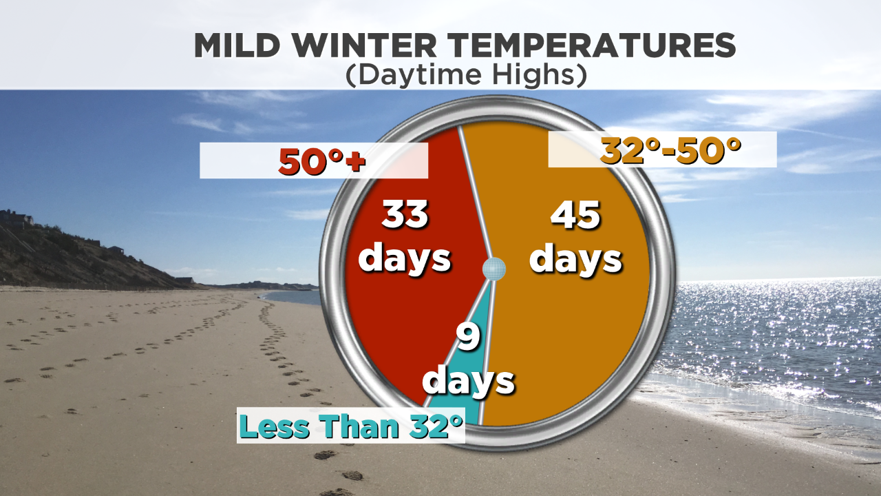
This winter? You couldn't dream up something farther away from those days. We are on pace for a Top 5 warmest winter *ever recorded* in the Boston area. Many parts of New England could finish #1 all-time. We have had a whopping 33 days over 50 degrees in Boston, which is a record. More than a third of the whole season (Meteorological Winter) above 50F. I mean that just boggles the mind. For recent perspective, the very warm winter of 2011-12 only had 25 days over 50F. We nearly had that many in December alone (20).
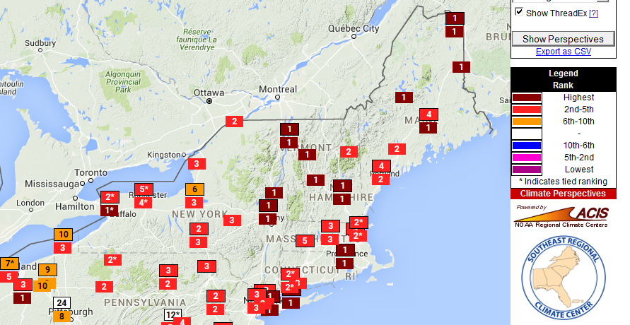
Here are the current rankings for warmest winter on record across the Northeast. Looking at the forecast which includes several more days in the 50s, many towns have a shot at their all-time top spot. Source: Southeast Regional Climate Center
We will probably hit 50F again on Sunday and again on Monday, for a grand total of 35 days. Taking that into account, it will be interesting to see if we can move all the way to warmest winter ever recorded in Boston before Monday comes to a close.
How about the ocean? Just a week from now, 'ice bergs' were a national sensation as they drifted in to the Cape Cod shore. Wellfleet Harbor looked more like Nunavut as these giant chunks filled the water. Ferry service had halted in spots, forcing commuters to find alternate arrangements into the Boston area. And the Charles ice was so thick you could walk out across it (although never recommended).
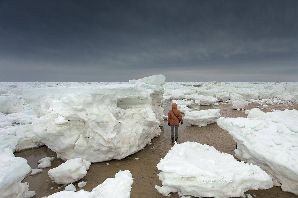
Huge chunks of ice come ashore in Wellfleet Harbor during early March, 2015. Photo via @Dapixara
This year ice fishing derbies in Maine are being canceled because...there's no ice. The Charles River is most certainly ice free. Water temps are in the 40s, a far cry from the frigid 30s we had last winter. And there isn't much cold on the way as we head into March.
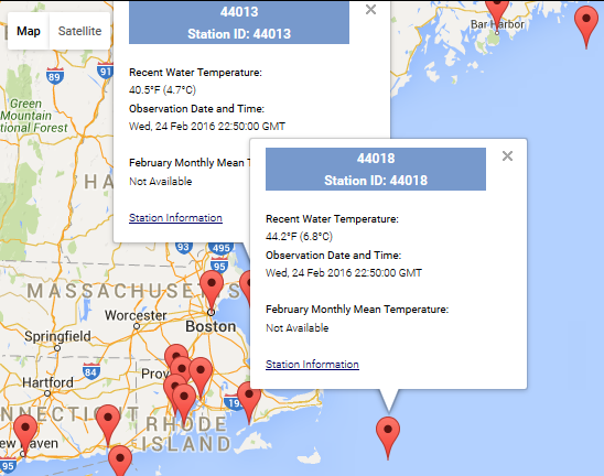
Current water temperatures at 2 nearby buoys. Source: NODC
And how about the snow cover? Locked in would be one way to put it at this time last year. It was so cold that the snow kept on piling up without melting between storms. The average Northeast snow depth was a little over 2 feet. If you're a skier or snowmobiler, it doesn't get much better than that. And those same winter enthusiasts are feeling the pain this time around. I'm starting to wonder how long ski areas will even try to stay open under these brutal conditions. Another pouring rain event last night, no snow in the forecast, and many running only limited trails before this recent storm. It hasn't been a fun run. And as mentioned above, all of southern New England is nearly snow free here as we move into the home stretch of the month.
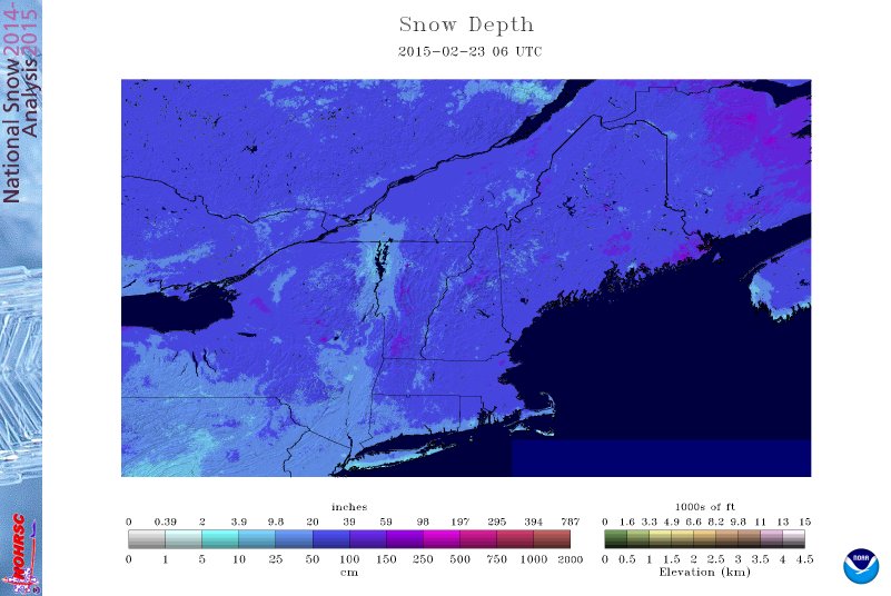
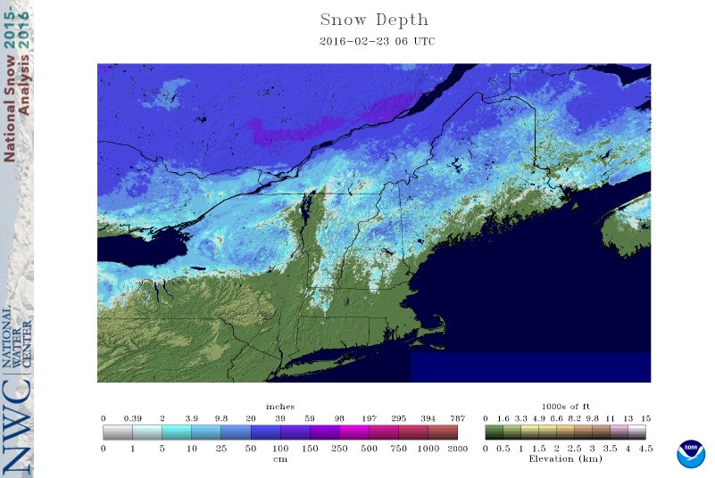
A comparison of snow cover. Source: NOHRSC
So what does it all mean? Well for starters, I can say definitively that people are more concerned when they feel warm temperatures in winter than cold. The departures from average are pretty much the same between winter of 2014-15 and the winter of 2015-16. They were equally 'extreme' if you will. But when it's really cold out in winter, people just shrug and say 'eh, it's winter...it's supposed to be cold.' The reactions are not alike.
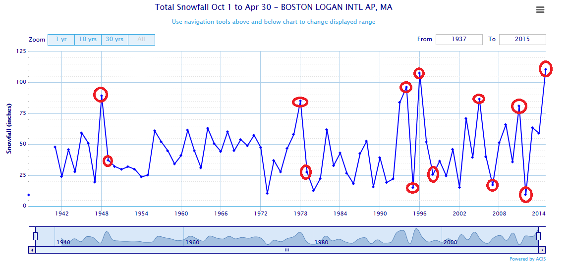
The highest highs are nearly always immediately followed by the lowest lows. Source: ACIS
Also, keep in mind that this was widely expected. No one thought this was going to be a harsh and snowy winter. There were no signs pointing to it being one. We had a mild November, a record level El Nino, and were coming off a big snow winter. We nearly ALWAYS see a massive drop in snow totals after a huge snow year. That's been the same since record keeping began in the area. There's something to be said for nature balancing out. When there's a strong pull to one extreme, sometimes there's an equal pull to the other side. The winter outlook was for warmer than average temperatures and lower than average snow. We definitely checked both of those off the list.
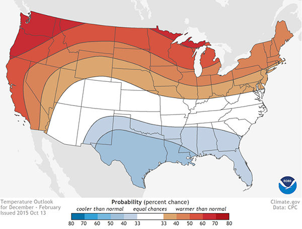
And if you look at the temperature anomalies this winter, you know what it looks like? A general El Nino winter outlook. They're not all the same and you can't broad-brush, saying 'El Nino means X.' But there are outlooks for a reason. Certain factors can help lead to certain outcomes. The warmest anomalies/ridging moved a little farther east than the 'broad-brushed' approach, which in turn sent some of the cooler air back toward the inner mountain west than the south-central U.S. But the warm northern states verified just fine. The Northwest has been warming in recent days and it will likely show up warmer there than on the current anomaly map by the end of the month.
A flood of Pacific air kept flowing into the country, with very few arctic intrusions (oh, except that generational level cold shot that you've probably already forgotten about last week). If you don't have dry polar air coming in, it's not going to stay very cold.
What follows this? Well it's too early for a Winter 2016-17 outlook. But signs point to ENSO-neutral or La Nina by late summer. That means El Nino will leave us, and we may end up a lot more focused on hurricanes than snowstorms in the short term. The Atlantic is very warm right now and once El Nino takes a breather, wind shear will likely relax across the Caribbean for the upcoming summer. So a busy tropical season is likely in the cards, and after that I would imagine a winter that won't be nearly as warm as the one we're about to leave.


