Only In New England: From Record Cold To Possible T-Storms
BOSTON (CBS) -- Every once in a while Mother Nature has to clean out her cupboards.
In a 48-hour span, most of us in southern New England will have seen record-setting cold, accumulating snow, sleet, freezing rain, fog, powerful winds, torrential rainfall and near record warmth. That is truly what I would call an "Everything but the Kitchen Sink" storm.
Check Radar | Current Conditions | Get Weather App
Just two days ago, Boston had its coldest temperature (-9) in 59 years. Today we are going to come up just a few degrees shy of a record HIGH temperature (60 set in 1910).
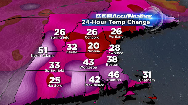
Just two days ago, wind chill values were as low as -40 degrees. this afternoon the winds will blow strongly again, but from a different direction, perhaps fueling a few thunderstorms!
Where else could you drive to work in the morning, white knuckles, through ice and snow, and drive home that same evening in a windswept, warm rain with a few rumbles of thunder? Only in New England.
Let's break down the remainder of this remarkable weather event. . .
Tracking the downpours. . .
We are expecting .5" – 1.5" of rainfall in about 4-6 hours this afternoon and evening. This will lead to some poor drainage and street flooding.
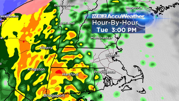
3 p.m.: Pouring in western Mass. and all areas west of Worcester
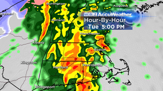
5 p.m.: Heaviest rain now in Worcester County, few downpours spread into 495/128 area as well
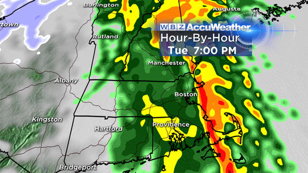
7 p.m.: Torrential downpours now in Boston and along the Coastline, rain shutting off west of Worcester
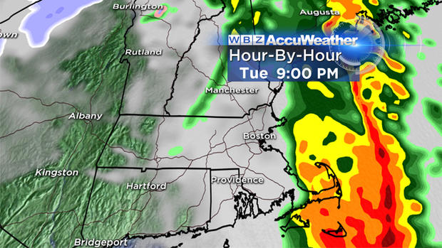
9 p.m. Last of the downpours exiting the Cape and Islands, elsewhere drying out
Tracking the wind. . .
The wind will be the biggest concern this evening, with some gusts as high as 60 mph possible within some of the downpours. Strongest winds will coincide with the heavy rain (between 3 p.m.-9 p.m.). Best chance of damaging wind gusts will be areas closer to the coastline.
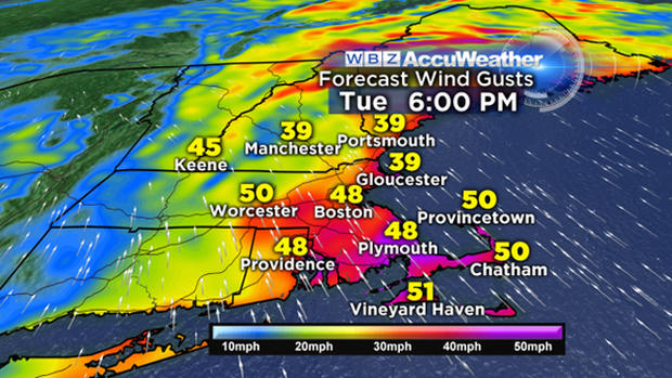
Unlike the frigid northerly winds over the weekend, today our winds will blow from the south. With gusts topping 50 mph along I-95 and over eastern Mass., some trees and branches may come down and some spotty power outages are also likely.
What's next?
Thankfully there won't be a flash freeze. Temperatures will slowly fall overnight and only drop near or slightly below freezing briefly around dawn on Wednesday. So while there will be some icy spots where water refreezes, I would not expect any significant travel issues Wednesday morning.
And then, it is quiet for a while. Our next storm chance comes late Friday and Saturday, but this weak, moisture starved disturbance will only deliver some minor rain and snow showers. No Arctic cold, no accumulating snow in Southern New England in the foreseeable future. Next timeframe to watch for any sizeable storminess would be the middle of next week, too early to speculate on what that could bring.
Follow Terry on Twitter @TerryWBZ