Brutal Cold Rolls Into New England On Valentine's Day Weekend
BOSTON (CBS) – Brace yourselves. The polar air is descending upon us today.
Watch: Latest Weather Forecast
Temperatures this morning are cold, but tolerable as long as you have layers on. The wind isn't a factor yet either.
The wind picks up this afternoon, and will stay strong overnight. Wind gusts between 30 and 40 MPH are likely. Sustained wind from the northwest 15 to 25 mph. Most of us will be partly sunny, with a passing flurry chance.
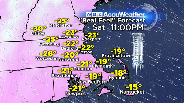
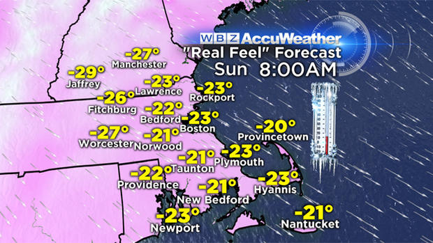
That wind, combined with the arctic cold temps, will create dangerous wind chill values. It'll be -25 to -35 degrees from this evening through Sunday afternoon.
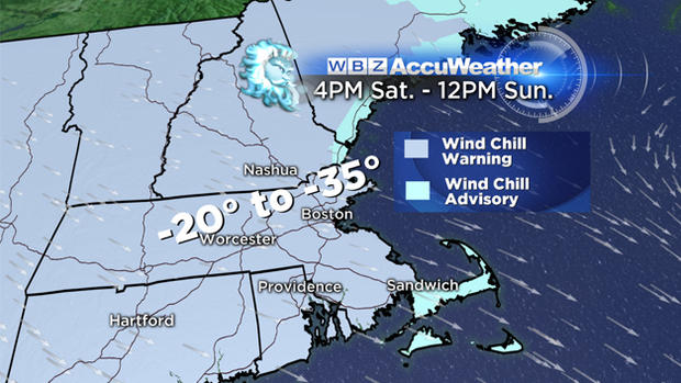
A wind chill warning is up for most of New England 4pm to noon Sunday. A wind chill advisory has been issued for Cape Cod & the islands 6pm to noon Sunday.
FRIGID VALENTINE'S DAY
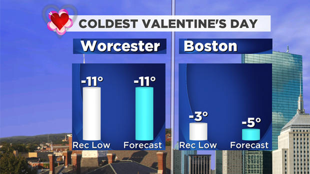
Valentine's Day may be the coldest on record.
Not only for the record lows in the forecast, but also for record low maximum temps both in Worcester and Boston.
There's good news though. This cold snap doesn't last long! By Monday it will feel milder with highs in the mid-20s.
WARM UP COMING?
And on Tuesday and Wednesday…wait for it… temperatures in the 40s!
Those days also bring us a storm that could give us late Monday night snow changing to a wintry mix Tuesday morning, then to rain by afternoon. Stay tuned for more details on that storm.
Chance for Snow?
The Cape and parts of Plymouth County picked up around an inch of powdery snow last night. A northwest wind tonight will give the outer Cape a chance for light ocean-effect snow tonight. Another 1-2" of snow will be possible through Sunday morning.
Follow Pamela Gardner on Twitter at @PamelaWBZ4