Will Christmas Eve Shatter Weather Records?
BOSTON (CBS) -- Ah, Christmas in springtime. The flowers are re-blooming, the birds are returning, and Santa is suiting up in his special dry-fit, breathable red tights. While I think most of us would agree that a little snow on Christmas helps to set the mood, we gotta play the hand we're dealt, and this year a record-setting El Nino is dealing us a downright "blowtorch," a hot and steamy holiday. I would urge you to make the most if it, break out the barbecue, toss the new Patriots football around the yard with the kids--the snow and cold will come back, they always do.
Download The CBS Boston Weather App
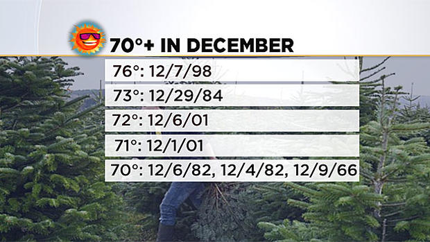
While we certainly weren't expecting it to be THIS warm, we were forecasting a mild start to winter given the current state of the atmosphere. In fact, nearly all the warmest December days in our history have occurred during or just after a strong El Nino. We have hit 70 in December just 7 times in the nearly 150 years of record in Boston. We have a shot at making number 8 on Christmas Eve. Again, looking at the list of 70s in December, we see every one come during or just after an El Nino.
Related: Warm December Winners And Losers
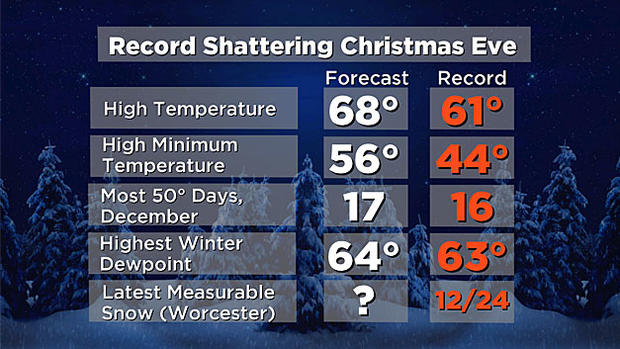
Among the records we are challenging:
-Warmest December on Record
-Most 50 degree days in December
-Highest dewpoint ever in winter
-Latest measurable snow in Worcester and perhaps Boston as well
So, let's get to the sultry details:
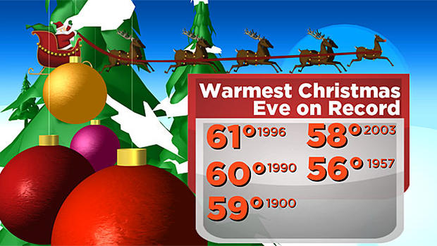
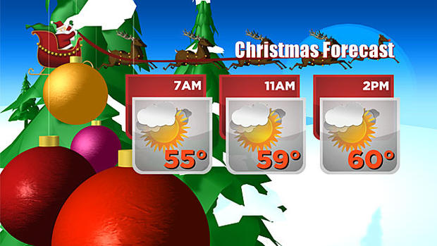
Remember the 4th of July from this year? Our Christmas Eve forecast will be very similar…no, seriously! The high on the 4th this year was 72, with a low of 62. Right now we are forecasting a high of 68-70 with a low near 60 on Thursday. This would shatter the record high for the date, which currently stands at 61 degrees, set back in 1996. There will be lots of clouds around during the day, but some sunny breaks will help to boost temperatures toward 70. Expecting a dry ride for Santa under mostly clear skies and a full "cold" moon (the first since 1977). Temperatures Christmas morning will hang in the 50s and stay there most of the day as well, perhaps climbing to 60 again in a few spots. There should be a good deal of sun on Friday, with some clouds rolling back in late in the day.
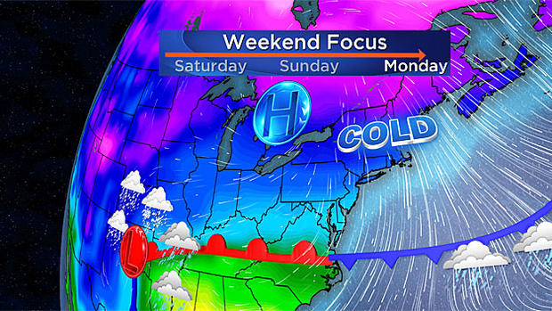
Finally, I would be remiss if I didn't mention a potential BIG change in our weather for next week. There are signs that we could get much colder by Monday and Tuesday. High temps would actually be near "normal," in the upper 30s in spots. Our first real chance at some wintry mix/snow arrives Tuesday. It's too early for much speculation, but definitely something to keep in the back of your mind. Like I said, it's not a matter of "if," but "when" our first snowfall arrives.
Happy Holidays, and safe travels.
Terry
Follow Terry on Twitter @TerryWBZ