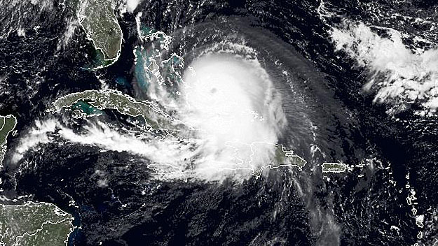
Hurricane Joaquin's Track Difficult To Forecast
BOSTON (CBS) -- The trend is our friend; a common phrase likely being said in many weather offices along the East Coast today when discussing Hurricane Joaquin. We knew this was going to be a complex forecast and it has lived up to the billing.
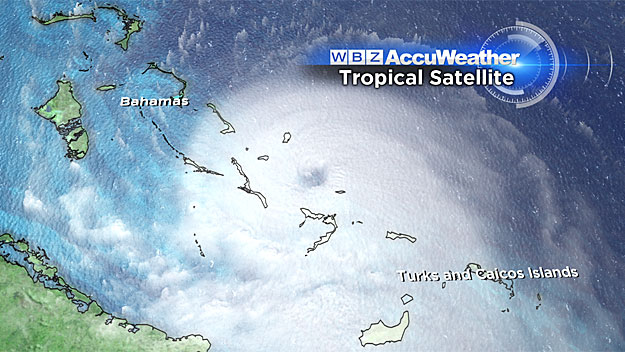
View: Hurricane Tracking Maps
While most weather models slammed Joaquin into the mid-Atlantic near North Carolina at this time yesterday, just 24 hours later many of these same models are offering a much different solution.
I'll try to keep the "geek speak" to a minimum here but the explanation is rather complicated. There are several large atmospheric factors at play over the next several days.
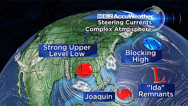
First, you have a deep and digging jetstream over the Eastern United States. This is the type of situation that you would rather not see with a hurricane in the Bahamas. Under "normal" circumstances a jetstream configuration like this might mean an East Coast direct hit. We also have a giant area of high pressure sitting over the northern Atlantic, funneling in a strong easterly wind up and down the East Coast.
Many times an air mass this big could serve as a "block," forcing a hurricane back to the west. And in fact, if Joaquin were already heading north, this is exactly what would happen. Between the trough in the jetstream and the blocking high off our Coast, the hurricane would have no choice but to head right for the East Coast. But it now appears as though this will not be the case.
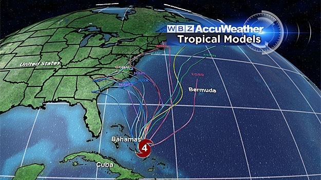
You may have heard us meteorologists use the model term "EURO" before. The EURO is a European weather model which has become very reliable in recent years. It had Hurricane Sandy pegged from the get-go, many days in advance. Since Joaquin became a story near the Bahamas, the EURO has been the one model that has consistently had an out-to-sea track. Beginning last night and now to a higher degree today, many of the other weather models are starting to buy in to what the EURO is preaching.
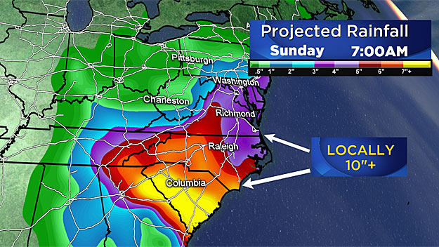
Taking the current EURO forecast at face value, Joaquin would never come anywhere near the East Coast. The only significant effect would likely be a band of heavy rain extending hundreds of miles north and west from Joaquin's center. This would likely dump copious amounts of rainfall over the Carolinas, perhaps a foot in spots from tonight through the weekend. As of this writing this is the most likely scenario. However, until Joaquin begins its jaunt northward Friday morning, we won't truly be 100 percent confident in ruling out an East Coast landfall. So as always, I would urge that you stay tuned for another 24 hours and see this forecast through to a final solution.
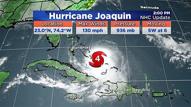
Lastly, you may have seen an official hurricane forecast track from the National Hurricane Center today that looked very alarming. When there is a hurricane in the Atlantic, the NHC puts out an updated forecast discussion and track every three hours. This includes the now-famous "cone of uncertainty" with a center line forecast track.
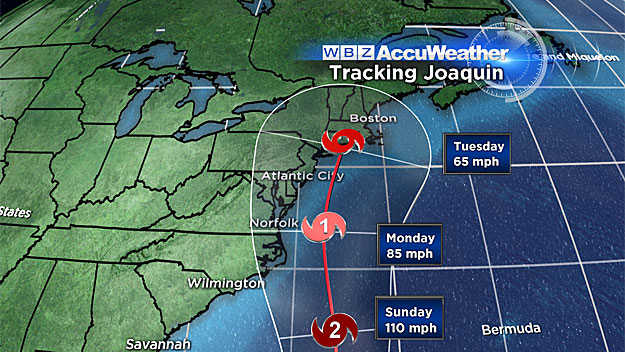
Given that the two major model solutions today are either into the mid-Atlantic or well out to sea, that cone of uncertainly was very large and the official track (center line) was drawn right up the middle, which brought it into southern New England. If you read their discussion you would have seen that this line didn't represent where they thought the hurricane was headed but instead was an average of the most likely outcomes. Tough position for them because most folks see the track and immediately assume that is the true forecast, when in actuality nobody ever thought that a track up into New England was a "likely" or "probable" scenario. All the more reason why the Internet and social media world can be dangerous in situations like these without any proper professional analysis to go along with it.
Again, we would urge that you stick around and pay close attention to forecast updates through tomorrow. But at this point, the weekend here in New England is looking a lot more reasonable. Notice I didn't say "nice." Lots of clouds through Sunday and periods of showers and drizzle, but it could have been a lot worse. If you've got weekend plans, Sunday looks to be the drier and likely more palatable day.
Follow Terry on Twitter @TerryWBZ