Feast Or Famine: Big Rain Event To Break The Drought
Find Eric Fisher on Twitter and Facebook
How often have you heard it? Droughts end with floods. It happens frequently in the world of weather when a pattern that's been stubborn for months (or sometimes years) all the sudden snaps and the storm clouds are unleashed. That looks to be the case this week. After months of mainly dry and sunny weather, we're going to make up for lost time in a hurry. The best case scenario is that we get soaked but not inundated, breaking the drought but not reaching a destructive level of rainfall. The worst case scenario would be for a very impressive and possibly damaging rain event spread out over several days. Let's break it down one factor at a time.
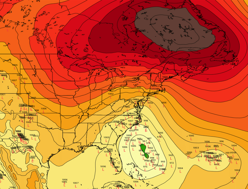
This is one model depiction - the ECMWF ensemble system. It shows the unusually strong ridge over SE Canada, but also the wide range of possible low pressure positions underneath it. It's how Joaquin interacts with a complex set of features that will determine how high impact this week's weather is. Source: Weatherbell
For starters, we've got an anomalous (unusual) setup. Over and over again we see odd/extreme outcomes when gigantic ridges like this form. They can trap storm systems and draw in large amounts of moisture as the typical west to east push of the jet stream goes away and you get more of a meridional flow from south to north. Most models are projecting this kind of setup late in the week. That opens up the tropics for business - allowing deep moisture to move poleward. That means the air over our heads will be laden with water vapor and just looking for an exit route. A large ridge over southern Canada with an approaching trough to the west and hints of Atlantic blocking are also a concerning pattern to allow tropical systems into the eastern seaboard. With Joaquin out there, this is a big player in the forecast.
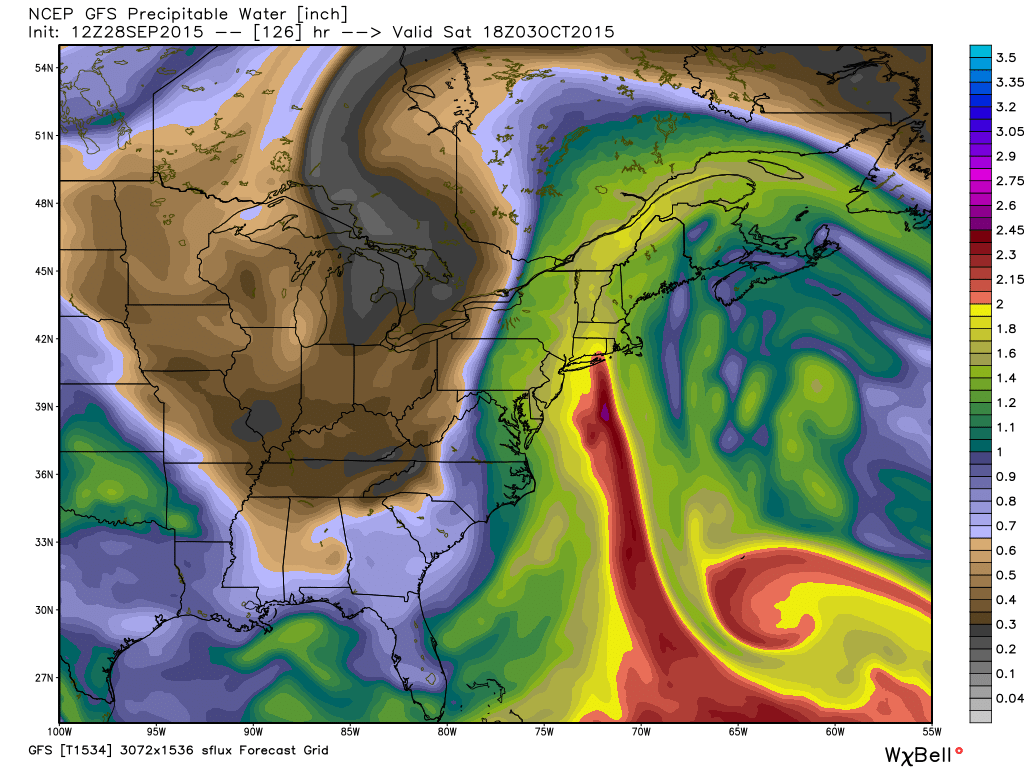
Precipitable water values will be running high, and it looks like Mother Nature is giving us the finger! A plume of deep tropical moisture extending up from the Bahamas/Caribbean. Source: Weatherbell
To focus all that moisture, we have an approaching cold front. This moves into the area Tuesday night, and slowly pushes east through the day on Wednesday. That tropical feed is forced to rise up along the front, and the result is a whole lot of rain. I think we should be able to squeeze out a widespread 1-3" of rain Tuesday evening through Wednesday night, with locally higher totals of 3-5". If the landscape was already very wet, this would be a problem. But there's actually a silver lining to us being in drought. The rivers and ponds are so low that they'll be able to take a soaking without flooding concerns. Even 3-5" likely wouldn't be enough to cause much in the way of river flooding. However, urban areas are more susceptible to flash flooding when you get that much in a short amount of time. Cities like Lowell, Lawrence, Boston, Worcester, New Bedford, Fall River, etc are places that may have issues with this. The same advice always holds - turn around and don't drown! Never drive through flooded roads...it's a good way to get into a lot of trouble.
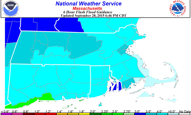
Flash flood guidance shows we'd require over 4" of rain in 6 hours to produce any river flooding here in southern New England. Many area streams and rivers are near or at record low stream flow, which gives us a little wiggle room when it comes to all this heavy rain. Source: http://www.srh.noaa.gov/rfcshare/ffg.php?location=MA&zoom_map=state&duration=6
As the front slips east, a tight pressure gradient will funnel strong NE winds down across eastern New England. They may be strong enough to produce some scattered damage Wednesday night into Friday, with gusts 35-50mph at the coast. These stronger winds will mainly be confined to the shoreline and far southeastern Massachusetts, with a diminishing wind impact inland. The other problem with these northeast winds are their longevity - we'll likely have days with the same wind piling up water along the coast and building up the surf. So very rough seas, waves potentially over 12' offshore, and minor coastal flooding in the usually prone areas are all on the table during this time. If you live near the ocean you've probably noticed that the tides are very high due to the supermoon Sunday night. Those high astronomical tides are a factor, and will be highest on Wednesday.
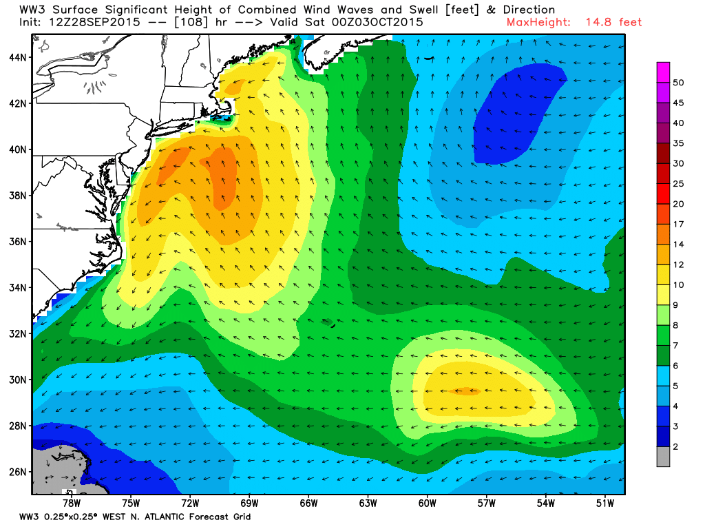
NOAA's Wave Watch model indicating some very rough seas from New England to the Mid-Atlantic late this week. Source: Weatherbell
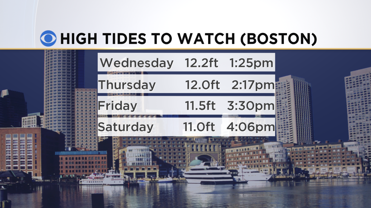
Tide cycles to watch

Erosion is another side of these prolonged winds. It's likely some beaches are going to take a beating during the second half of the week with continuous rough surf running high. Nantucket, Cape Cod Bay, and Plum Island are all areas to watch. It's the first real test of the season, and hopefully we won't see the sands shifting too dramatically. But it's definitely something to keep an eye on.
 Animated loop showing Joaquin churning east of the Bahamas.
After this first round of storminess - we get to arguably the most important part of the forecast. This all hinges on what Joaquin does, how strong it becomes, and its eventual path. There's still a ton of uncertainty as to how all this evolves, but to me it's likely that it gets entrained into this front and possibly 'captured' by an area of low pressure inland, all drawing the storm into the East Coast.
Will it become a powerful tropical system? I'd say chances are more likely than not that it will remain below hurricane status. It's best chance to intensify should be during the mid-week. But just because a storm doesn't have tremendous winds doesn't mean it can't have a large impact. Tropical moisture getting thrown up along our stalled front could potentially bring several more inches of rain. After the initial soaking this could lead to a larger flood concern.
A big part of this depends on where the front stalls. If it's slightly offshore Thursday into Friday, a much needed lull will allow for some runoff between storms. But if it retrogrades back inland quickly and rain returns along with it for a big part of Thursday and Friday, then we could get into that more concerning territory.
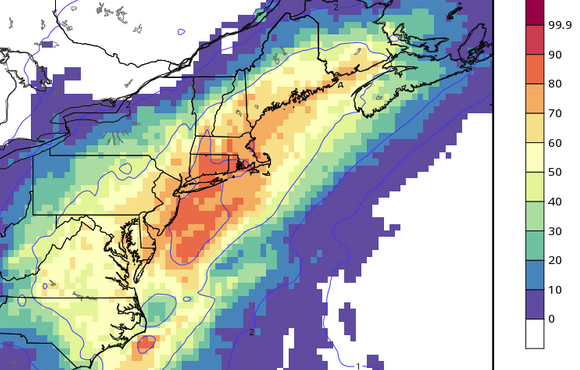
This is an interesting product from the ECMWF ensemble system. It's showing the progged probability of rainfall over 4" Wed-Sat. When it's throwing out 70-90% odds, that indicates a strong signal for heavy rainfall. Source: Weatherbell.
We forecast the 'most likely' scenarios but tell you about the 'worst case' setups because if it's in the reasonable realm of possibility, you should know about it and be prepared. So let's play best case vs. worst case.
Best case:
- Soaking rain Tue PM - Thur AM, widespread 2-4"
- Gusty and raw but not damaging winds (below 40mph)
- Joaquin dissipates or is drawn inland to our west, sparing us heaviest rain
- Drought is dented in a big way, some nuisance flooding, generally ugly but O.K.
Worst case:
- Soaking rain Tue PM - Thur AM, widespread 2-4"
- Wind gusts reach 40-50mph at the coast, bring down some limbs/trees
- Significant wave action/erosion
- No 'lull' Thursday/Friday - rain continues
- Joaquin heads into New England, another 3-6" of rain Saturday
- Significant flooding Fri/Sat into Sunday
What to do to be prepared? Well it's probably been a while since you dusted off the sump pump around here...so make sure it works and have it ready if necessary. If your basement routinely floods be prepared to see water move in. Power outages don't look like a big threat, but keep a flashlight handy (mainly near the coast). And use common sense when traveling in heavy rain. Avoid those flooded roads, and keep a watchful eye on the backyard stream or creek. We may see some significant rises later this week.
We'll be keeping you updated all week long and will make adjustments when (if) necessary.
![]()