Meteor Showers & Meteorological Showers
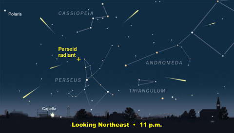
This is a week that I always look forward to because it contains the Perseid Meteor Showers. Check this link to Sky & Telescope Magazine for more information. These so-called shooting stars max out on the night of August 12 into the 13th. The prime time is about 2-4 am on the 13th when the potential exists for seeing 100 of them! For optimum viewing conditions, get far away from city lights and look to the northeast where the meteors tend to shoot out from the constellation Perseus. There will be no interfering moonlight this year thanks to the new moon phase. Regarding the sky condition, most signs suggest a partly cloudy to mostly clear sky with no haze tomorrow night and early Thursday morning for you to see the show. Some Perseids can be seen several nights before and after the peak night.
 In the meantime, beneficial rain is in the forecast for much of but not all of the region primarily north and west of Boston today. Expect embedded lightning and thunder with a slight risk that there could be a few spotty strong to severe storms during the afternoon especially if any splashes of sunshine develop between the numerous showers. The most common impact will be flooding in poor drainage areas under some of the tropical downpours feeding on the very humid air. There is a chance that additional showers and storms could release a half inch or more of rain over southeastern MA and parts of Cape Cod in the early morning hours tomorrow.
The landscape has really dried out in the past few weeks despite the brief hits of torrential rain here and there. Many lawns have turned brown and crunchy and the flower and vegetable gardens need a good solid drink of water not just a quick 10-minute shower where much of the heavy rain runs off and doesn't soak in. There has only been one month out of the last six with above average rainfall and that was the month of June. March, April and May were well below average in precipitation and July-August is following the same path.
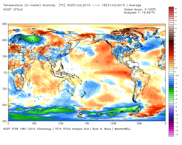 It is interesting that there has been little change in the position of the positive and negative sea surface temperature anomalies. These have been key drivers of our weather pattern for more than a year. The added player is the strengthening El Nino displayed as the warm water in the central and eastern equatorial Pacific Ocean.
In the shorter term, this setup could yield a spell of hotter weather for us later this month and perhaps into the first part of September similar to what happened last year. On August 27, it was 91 followed by 93 on September 2, 91 on September 5 and 92 on the 6th.
It is expected that El Nino will remain strong or even become a bit stronger going into the upcoming winter. How will this phenomenon interact with the ocean temperature anomalies? Presently, based upon analog years, it COULD mean another harsh winter overall but not a carbon copy of the 30-day siege of snow last winter. Instead, it would be distributed over a longer time period. Of course, it remains speculative now but based upon the cast of characters featuring an active southern stream jet linked to cold outbreaks from Canada, it is certainly plausible. It will be interesting to watch for other clues to predict what the seasons ahead will deliver. The WBZ AccuWeather Team will present our winter forecast on an "Eye On Weather" Special later in November. Until then, enjoy the rest of the summer!
Make it a great week!