20 Years Ago - Intense Derecho Strikes
Find Eric Fisher on Twitter and Facebook
Most of us are familiar with your 'pop-up thunderstorms' or severe storms that can bring brief strong winds or large hail. But I'm guessing few people on the street could explain what a derecho is. And that's *after* the very extensively covered 2012 derecho that caused millions of power outages from the Midwest to the DC area and Mid-Atlantic. These wind storms are infrequent in New England, but the one that ripped through 20 years ago today is one of the most infamous in the modern era, as well as one of the most costly severe thunderstorm events in the 20th century.
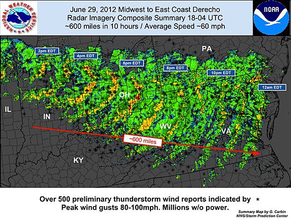
A powerful derecho travels from the Chicago area to DC in 2012, producing tremendous damage and winds in excess of 95mph. Source: NWS Storm Prediction Center
So what is a derecho (pronounced deh-RAY-cho)? It's a long lived wind storm that's both extremely intense and extremely persistent. To qualify for derecho status, the damage must continuously extend for at least 240 miles and have near-constant severe gusts over 58mph. On top of that, there must be several gusts over 75mph along the path. As you might imagine, this type of wind storm is pretty difficult to achieve. Imagine a freight train of winds traveling at a minimum from Utica to Boston, with winds that strong all the way down I-90. The damage can easily be greater than that of a tornado (and include a larger area).
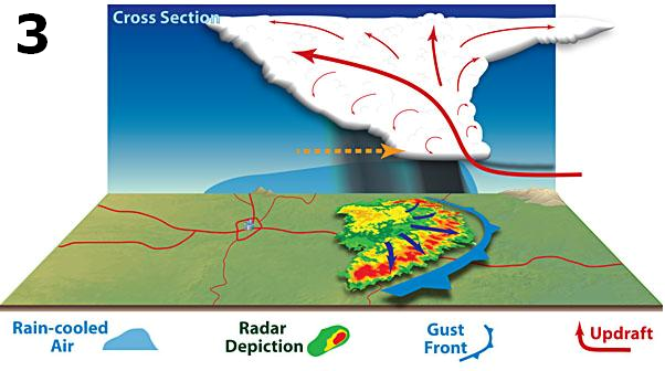
Modified from illustration by Dennis Cain - Source: http://www.spc.noaa.gov/misc/AbtDerechos/derechofacts.htm#development
So how do they form? Progressive derechos are most likely to develop during the hot summer months, along the top edge of high heat and humidity. They begin with the spark of a thunderstorm, which can then tap into strong mid-level winds and produce powerful downbursts (rain cooled air from above the surface rushing down). If the winds are generally unidirectional (blowing in the same direction over a thick layer of the atmosphere) they will help push this storm forward. A bow echo forms, and then grows over time as it feasts on warm and humid air out ahead of it. At this point it's a runaway train. The warm and moist air rises and cools, and that cold pool grows. Colder air is more dense, so it rushes to the ground. That colder air acts as a plow in front of a truck - shoving up more warm and moist air ahead of it. Now if you're in front of it, you may see an ominous shelf cloud rapidly heading your way. And so it goes until the bow echo eventually runs out of gas (unstable air).
Other features can travel along and pop up along the derecho - such as spin-up tornadoes, bookend vortices, and isolated supercells. And the line itself is often traveling at a very fast rate of speed - in most cases 50-70mph.
Source: Storm Prediction Center
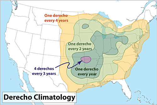
Derechos are most common in the Midwest, where there is often an ample supply of this hot and humid air to feed on. They're in the family of a more common occurrence in this part of the country - an MCS (mesoscale convection system). There are the big clusters of storms you see forming and bringing torrential rain/strong winds to everyone in their path (most frequently found forming at the tail end of the evening/overnight as a nocturnal jet forms). You could think of them as 'derecho light,' although they often feature damaging winds and flash flooding.
For us, the 'best' setup for a derecho is during a big Midwestern heat wave. High pressure builds over the Plains, and storms erupt on the northern periphery of this ridge. To really get it cranking, an elevated mixed layer (EML) is often present. This is essentially a layer of air that cools rapidly with height, but is above a lower level 'cap.' The cap is warmer air holding storms at bay at ground level. Once that cap breaks (with strong surface heating or forcing) the air finds itself in a very buoyant atmosphere and blasts upward with explosive storm development. This was the case in mid-July of 1995.
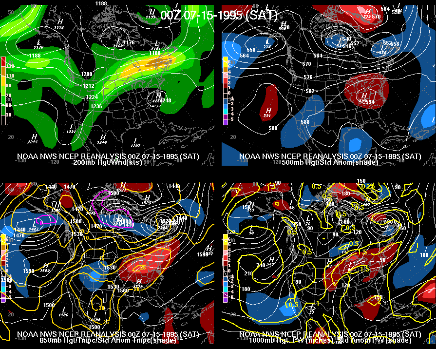
Source: NCEP Reanalysis
Source: Accuweather.com
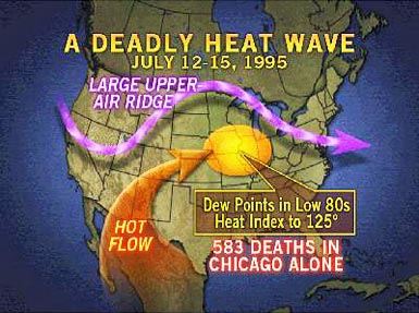
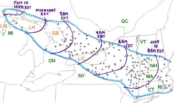
There was a deadly heat wave underway across the east, with temps topping 105F in the Chicago area and reaching up to a record high of 99F in Albany, NY. A large ridge of high pressure was controlling the east, and also boosting dew points well into the 70s. Meanwhile, a strong jet streak was located at the top of the ridge, where the MCS was born in Ontario. Below is an image of how quickly the situation developed downstream. The bow echo made it from Lake Onatrio to Worcester in only 4 hours! Each (+) on the map is a gust over 58mph. The peak gusts topped 100mph and ravaged the Adirondacks, where many campers were caught off guard and 5 people were killed by falling trees in the chaos. Locals often refer to it as the Blowdown of 1995. It's estimated that millions of trees were felled along the path, although it's impossible to get an exact count. Many areas of forest were completely flattened by the straight-line winds.
Source: Storm Prediction Center
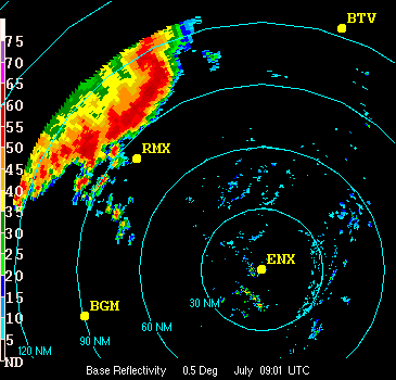
As the bow echo passed Syracuse, the airport reported a 76mph gust and a commercial jet was thrown into another parked jet on the tarmac. Still going strong in Albany, a 77mph gust was reported. Into the Berkshires roared the line, with a 92mph gust in Otis. Even all the way out on Martha's Vineyard, 800 miles away from the start of the line, a 58mph gust brought down trees. According to the Storm Prediction Center, the average speed of the derecho was an incredible 67mph.
The derecho approaching Albany, NY. Note the booked vortex on the northern edge of the line. Source: J. Waldstreicher, NWS Albany
The record heat, humidity, and upper-level setup was so persistent that several derechos formed during this one week alone (image at the top of the story). Forecast of these events has become much better in recent years as understanding of their formation improves. But they often begin and move so fast that there's not a lot of lead time for all of us on the ground. The exact track details often don't come into focus until the day of the event as leftover outflow boundaries, debris clouds, and mesoscale details really dictate their path. However, it's a good reminder that anytime you hear a meteorologist mention the possibility of one, it may be a good time to stay alert!