When Will The Snow Stop Falling?
BOSTON (CBS) - Yep, we did it. Whether you were rooting it on or throwing things every time you heard 'record snow' on TV or radio, we've already gone through the snowiest season in the recorded history of Boston (which goes back to 1891). And while other epic seasons were over a long period of time, the slope of our ascent was by far the steepest. Nearly all of it came in a month. Now that we've hit our milestones and spring is around the corner, the only question on most people's minds is 'are we done yet?' Sadly the answer is no, we are not out of the woods just yet from both a climatological and forecasting point of view.
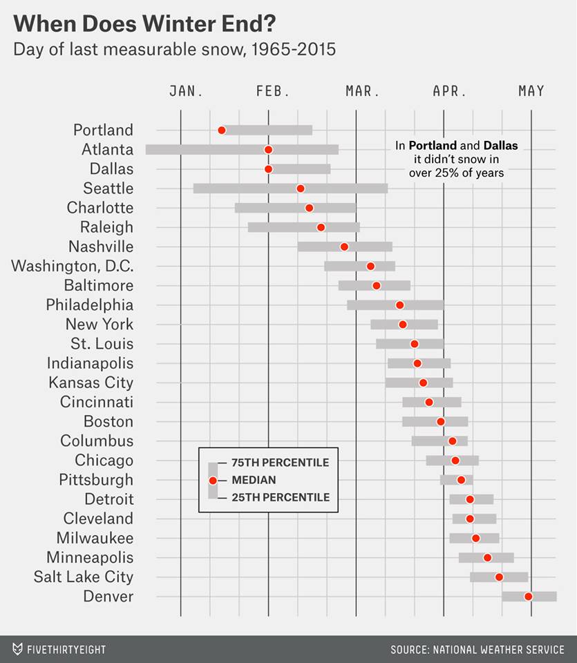
From an analysis by FiveThirtyEight
Let's start with the climo, which is average weather over a long period of time. We know that in the past, it has snowed well beyond 'winter' in this part of the world. The main storm that comes to mind is of course the April Fool's Blizzard of 1997, arguably one of the most incredible snowstorms in the modern era (I'd say it's up there with the Blizzards of '78 and '69 and the freak October snowstorm in 2011). It crushed the region with heavy wet snow - over 2 feet in Boston and 33" in Worcester. Until it was dethroned this year, it held the top spot for largest snowstorm in Worcester's history.
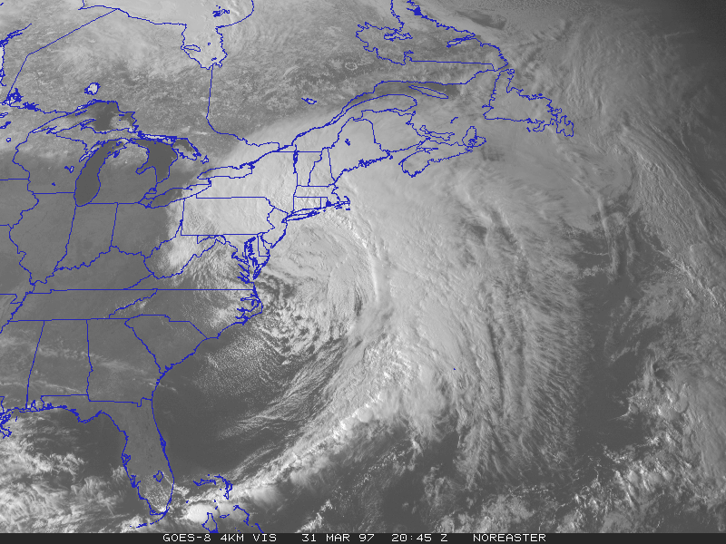
The April Fool's Blizzard of 1997, as seen by NOAA satellite.
But just because we remember the April Fool's Blizzard doesn't mean it can't snow later. We have a Producer here who loves to remind me that when she was born on May 10th, 1977, there was plenty of snow coming down. Interior southern New England was slammed with almost unfathomable snow for May; 20" in Norfolk, Conn., 12.7" in Worcester, and 9.5" at Bedford, Mass. Boston received only 0.5", but still a very late measurable snow for the city. We have even picked up a 'trace' of snow in June in Boston! Many have asked if this late season snow counts toward the record. Indeed it does - any snow that falls through June will all count as part of the 2014-2015 season.
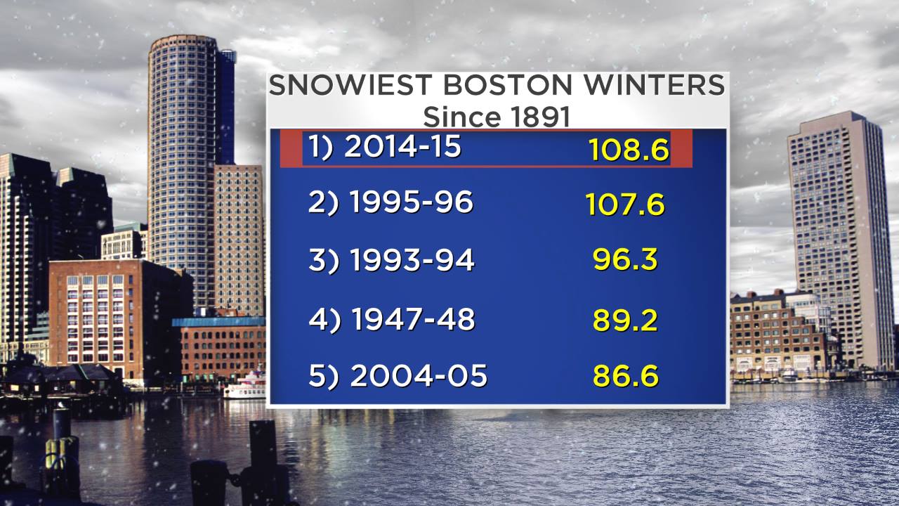
Looking back at recent years where we've notched new records, it's interesting to note the upward trend. For a long time, the snowiest season on record had been set in 1947-48, where 89.2" of snow floated on down in the city. At that time, the observations were still being made at Boston Logan Airport. Then came along the winter of 1993-94 and set a new mark at 96.3". We didn't wait long for a new champion - the incredible, drawn out, nonstop winter of 1995-96 produced a brand new mark by becoming the first recorded season to top the century mark - 107.6". And that brings us to our current state, standing in the #1 position with 108.6". It's interesting to note that each time a new record was set, it beat the old one by about 8-10%. For what it's worth, if that trend continues, we could end up around 115-118" before things end here in Boston this season. Let's hope past performance is not an indicator of future results in this case!
That brings us up to the forecast - what's in the cards for the weeks to come? I'm sure you've noticed that it hasn't exactly been a balmy March so far. We've manged to hit 50 a couple times in most towns, but other than that it's more of the same old song and pattern with below average temps. In fact, we're probably going to end up with a colder March here in 2015 than we had last year! Goes without saying it has been a tough stretch of weather to deal with - but at least our averages are moving up.
Cyclonic flow aloft on Wednesday and an upslope flow should produce numerous snow showers/squalls for west-facing slopes in VT/NH. Source: Weatherbell
So far as snowy chances goes in the near-term, there could be some snow showers around Wednesday but not adding up to much of anything toward our seasonal total. That should be a different story to the north, as snow showers should be directed into western facing slopes of northern New England - especially Vermont. Ski season will continue unabated - there's barely been a raindrop in that part of the area for months now. Hard pressed to find better conditions! With no foreseeable warm-ups you'll easily get some turns in for Easter this year.
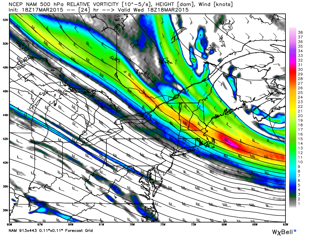
The next more significant snow threat arrives late Friday. There is still a decent amount of uncertainty as to whether this storm will get far enough north to bring us plowable snow, or hang just enough to the south to graze us with some low-impact flakes. The ECMWF model has been the most bullish and consistent model for days now - continually bringing accumulating snow into southern New England. It's ensemble members are also in good agreement that it will be far enough north to have at least SE Mass shoveling. For what it's worth - the European model has also been destroying the competition in recent weeks with extremely high 'verification scores.' It had a rough patch early this winter, but seems to be rebounding and forecasting the pattern very well.
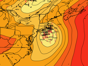
ECMWF EPS low locations from the 12z run on Tuesday, March 17th. Tight clustering tends to increase forecast confidence on where the low will set up. Source: Weatherbell
So the early call here is that snow will be likely, especially from the Pike southward. We may be able to pick up a few inches in Boston...putting us up over 110" for the season. Keeping an eye on this one over the next couple days. Are we finished there? Probably not. This is the pattern that just doesn't want to let up (we've generally been in the same jet stream setup over North America for about 2 years now, on and off but mostly on). The air mass progged to come in here Sunday will again be well below average, although not quite to record levels Sunday night. In any case, there's no real warmth to keep snow completely out of the picture.
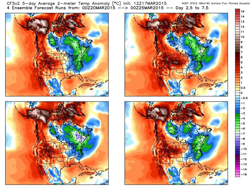
CFSv2 temperature anomaly outlook for days 2.5-7.5 (essentially end of this week into the middle of next week). Ensemble members in strong agreement for well below average temperatures in eastern Canada/Northeast U.S. Source: Weatherbell
Longer range models like the ECMWF weeklies and CFSv2 keep winter hanging tough well into April. An East Coast storm has been on/off on the models for the late March time frame, and another lurking in early April. For sure, all three of these storms mentioned could miss us, and not a single person would complain about that. But the point is that a risk is still here for weeks to come for some additional snow. A silver lining - snow this time of year doesn't stick around very long. The sun goes to work, especially as we head into April. The main issue with more snow would be that it could add to our still significant snow pack that hasn't been melting in a hurry..and won't be either. We're not hitting 60 until April, and may barely pick up a day or two over 50 for the rest of March. We don't want to add any additional water equivalent into our snow pack, because that would heighten our spring flood risk.
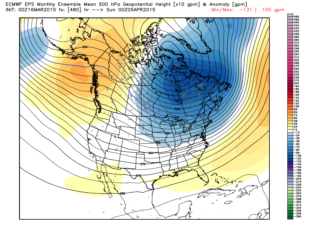
ECMWF EPS Ensemble Mean 500mb heights. The signal for deep troughing in the east continues all the way to Easter and beyond. Source: Weatherbell
In the end there's no doubt the temperature outlooks are easier than the storm outlooks. Where we stand we know that there's plenty of cold still coming and that March will go down with a large negative temperature departure. It's very likely this continues into early April. But whether these storms hit or miss us is much less certain. All we can do is hope that we finally start missing a few of these, and that we can continue a gradual melt as we exit a brutal winter!


