When Will The Snow Be Gone?
BOSTON (CBS) - As we begin to wind down from what is likely to go down as the snowiest winter in Boston's recorded history, we are left with one thing - snow.
And lots of it.
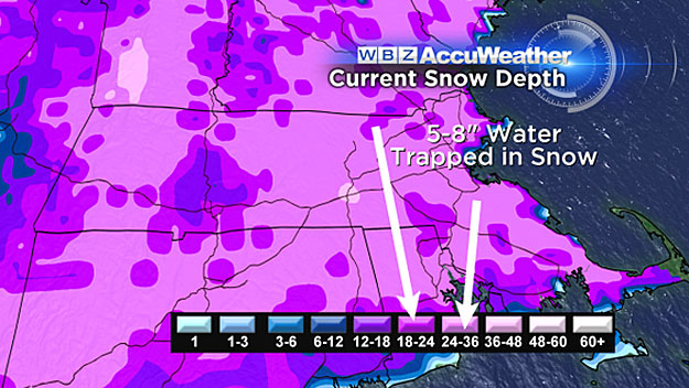
The current average snow depth in southern New England is right around 2 feet. That's 2 feet on our baseball fields, 2 feet on our soccer fields, 2 feet on our lawns and gardens.
Somewhere, buried in mounds of white, the green grass of spring is there, waiting to take in its first warm rays of sunshine in months. Getting rid of those giant snow piles will not be easy. There are several factors involved, most of which naturally, are weather related.
MARCH SUNSHINE
March sunshine is a beautiful thing. In less than two weeks the center of the sun will be crossing the equator. As the sun gets higher and higher in the northern hemisphere sky, we are gaining more than 2 minutes of sunlight each and every day.
By mid-to-late March, the sun literally starts to devour the snow. So, in most "average" years, the spring sports schedules are free to get underway in the month of March, albeit it during some very chilly days.
But, as you all know, this year is far from average.
February was not only the snowiest month ever recorded but also the second coldest month in our history. Through the first nine days of March, snow has fallen on 5 days and temperatures are averaging more than 7 degrees below average. Not nearly as harsh as February, but far from an "early spring" like many had hoped.
'HEAT WAVE!'
All the more reason why the next three days are going to feel a lot like a "heat wave!"
High temperatures will be in the 40's Monday through Wednesday, with a few towns even nicking 50 Wednesday afternoon.
This "surge" of warmth is actually only getting us back to average. We have spent so many days in the teens and 20's I think we are starting to get used to it. I have seen more than a few folks driving around with their windows down when temperatures have topped 30. The term "hardy New Englanders" has taken on a whole new meaning.
HOW MUCH WILL MELT?
So how much snow can we expect to vanish this week?
It depends.
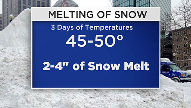
Typically, with 3 days of temperatures in the 45-50 degree range, you would lose about 2-to-4 inches of snow pack. As with most things weather related, this is not a cut and dry process.
The primary factors behind a spring snowmelt are air temperature and the intensity of the sun.
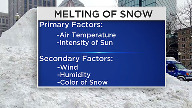
Other things to consider:
Humidity: The more moisture in the air, the faster the melting process. Snow will not melt well on a very dry day.
Wind: Strong winds can carry away moisture in the air, preserving the snow pack.
Sunshine: Can melt snow even on a day when temperatures are below freezing. In general, more snow will melt on a sunny day than a cloudy day.
Color of the snow: A bright white snow will reflect a good deal of the sunshine and melt much slower. The dirty, black snow absorbs the sunlight, leading to quicker melting. A great example of this, over the last week, in an effort to prepare for the upcoming season, the Red Sox had a few tons of black sand thrown on top of their snow.
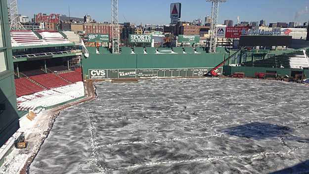
This is certainly a better option than driving plows over the well-manicured fields.
THE PHYSICS
If all of that isn't enough to make your head spin, there is actually a good deal of physics behind the process by which snow melts.
Snow will melt from top to bottom. The heat absorbed by the very top layer causes the snow crystals to break down. Once the gravitation force grows stronger than the adhesive force which binds the crystals together, the drops start to flow downward through the snowpack. Believe it or not, there is a LOT more to this process, complete with very complex equations. Google it someday if you have some free time, it will boggle your mind!
The bottom line - we will lose several more inches off of our record snow pack this week.
Unfortunately, this process will be slowed towards the end of the week by the return of chillier daytime and night time temperatures.
And then comes this weekend, we are tracking the potential for a wintry mix type event.
It's too early for specifics, but it may be one of those start as snow and gradually change to ice or rain events like we had last week.
It is possible that we could replenish all of the snow lost this week through melting by this weekend storm, making no net progress.
One step forward, two steps back.
Looking in the longer range, temperatures will likely remain below average for most of this month.
However, *if* we can stay snow-free, I would still anticipate that the majority of our snow pack will be gone by the end of March. Of course, that is a very big *if*.
Follow Terry on Twitter @TerryWBZ