More Snow & Cold As Winter Ramps Up
Find Eric Fisher on Twitter and Facebook
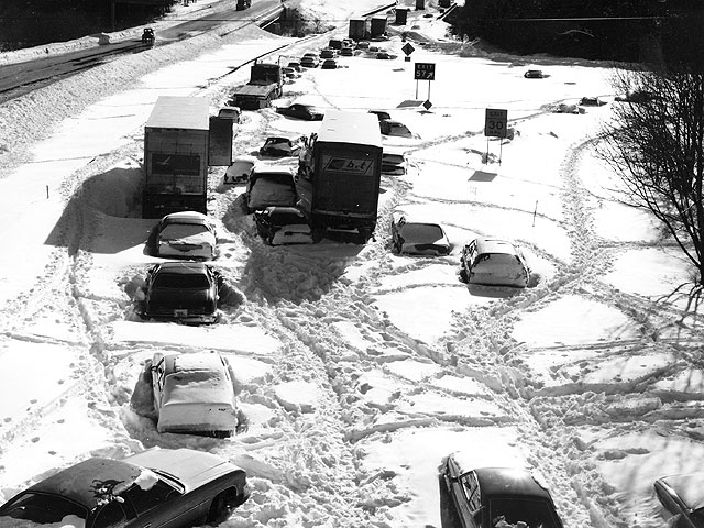
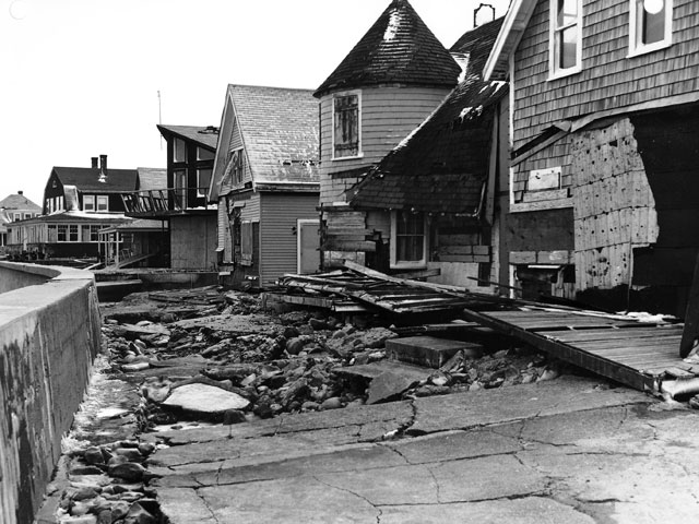
Fitting on the anniversary of the Blizzard of '78 to talk about some records of New England winter. Of course, '78 is still the benchmark storm, and it's the king for a number of reasons. It featured massive amounts of snow (most will say it's still the biggest producer in Boston history), but also destructive coastal flooding and wicked winds gusting over 80mph. It also came in a point in time when we simply didn't really know about things well in advance. We didn't have the technology we do today to spread information. We didn't shut down cities or keep people off the roads. There were no apps to check the steady snowfall moving in your direction, or to get a plow to your neighborhood. There are a myriad of reasons that it's unlikely we'll ever see a snowstorm have such a big impact on the population of southern New England.
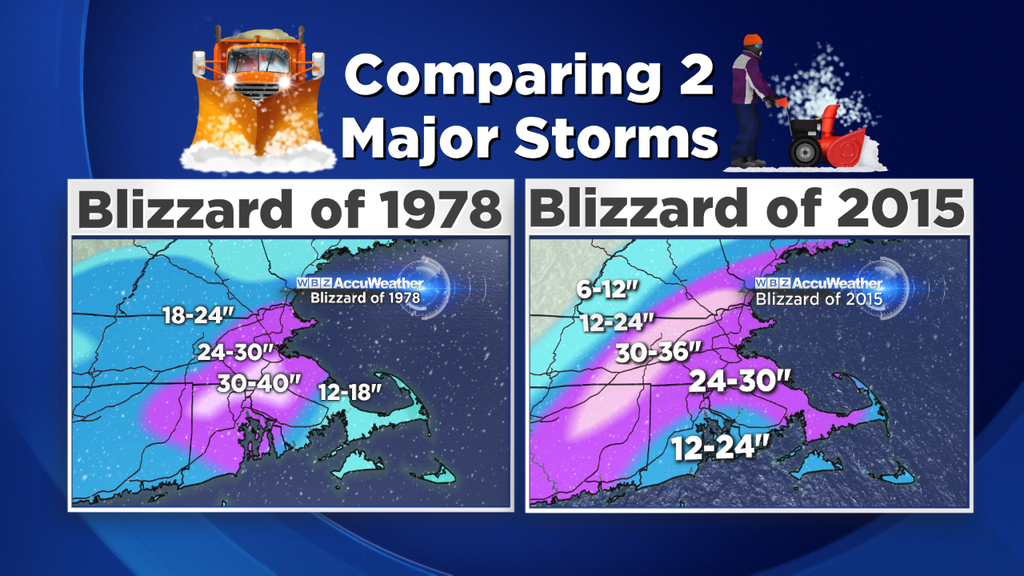
The 1977/78 winter was a big analog season we looked at when trying to figure out our seasonal outlook. And as luck would have it, so far it's looking quite similar. A bit of a slow start with big snows picking up in mid-January and some monster snow events. The '78 blizzard had the 'forgotten' storm on January 20th to precede it. However, there were 8 days with highs above freezing in Boston between the storms, including a stretch of 41F, 46F, and 55F in a row. In that sense, 2015 has been a little different. We had the big storm first, followed up by another foot and a half a few days later. And as for highs above freezing? Only 3, and all of those barely above that mark since the two big snow dumps. The forecast says we may only do that again once or twice for the next 10 days in Boston (and maybe not at all across the interior). So minimal chances for melting is keeping a deep snow pack intact.
What happened after all that snow in 1978? Big cold. February ended up being -4.7F below average...and we are well on our way to do the same this year. Today was our 13th straight day of below average temperatures and I think that streak is going to go to at *least* 22 straight days now. That's remarkably persistent cold.
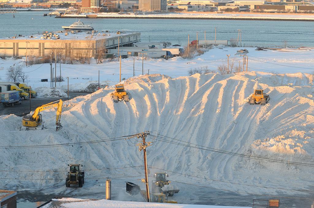
The snow farm growing in the Seaport district of Boston on Friday. Photo via @Coventures
In terms of snow records...here's a little laundry list of what we've achieved in the area in the last couple of weeks:
- Snowiest 5 day stretch in Boston & Worcester
- Snowiest 7 day stretch in both
- Snowiest 10 day stretch in both
- Biggest all-time snowstorm for Worcester
- Biggest January snowstorm on record in Boston (6th all-time)
- Biggest 10 day snowfall ever recorded in the state of Maine (Eastport)
- About to set record for record snow depth in Bangor, ME (record is 53", currently is 51")
Impressive stuff, especially when you consider what's expected over the next few days. Here are some of the bullet points ahead.
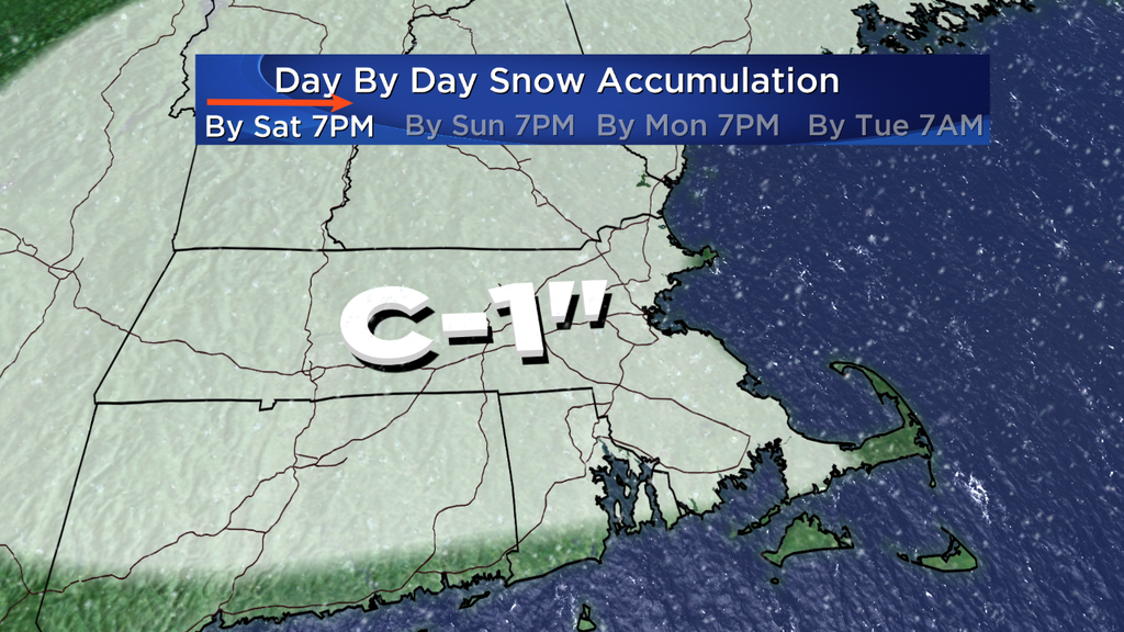
Saturday: Increasing clouds after a cold morning, and some areas of light snow should break out by dinnertime. Shouldn't have any major impact on the day, so use it to clean up and make room for more snow! There's a high water content in the snow pack on rooftops that's starting to reach dangerous territory. If you feel it's safe, please try to remove snow if you don't have a steeply pitched roof. If not, try to hire a professional. Another foot or more could really start to produce some big issues as the weight increases on structures.
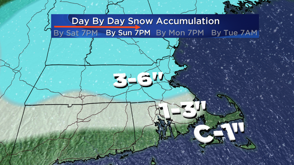
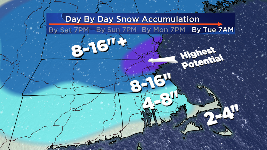
Sunday: Areas of light/moderate snow are likely throughout the day, but rates should be manageable. I wouldn't go canceling all your plans at this point. Stay updated with the forecast this weekend, but as of this writing I think plows should be able to do a good job of keeping up and although travel will be slow, it'll still be alright for those comfortable with winter driving conditions. Airports should be in decent shape with possibly some delays but not expecting widespread cancellations. This is especially true because this storm is highly localized. It'll basically only be snowing in New England and New York State...so there won't be a trickle down effect from multiple hubs around the country. The one part of this stage of the event that I'm not very confident in is SE Mass. If the band sets up a little more NW to SE, the totals could be a bit higher in that part of the state.
Monday: Highest impact from the storm. A more organized wave of low pressure should form along our stalled front and channel some stronger lift/onshore flow into the region. If we're going to have issues getting around, Sunday night through Monday will be the time frame for it. We'll see the most snow and highest rates at this point in the event, but we'll also see warming temps. There could be some icing/rain that moves up to the South Shore (and very likely Cape/South Coast/Islands) during this time. The 'lowest confidence' area of this forecast is SE Mass. There's a chance for totals to swing either way if the front/storm wobble just a little south or north. Highly recommend monitoring the forecast for any changes over the weekend as a small shift in the snow band could alter the end totals.
Longer Range Outlook:
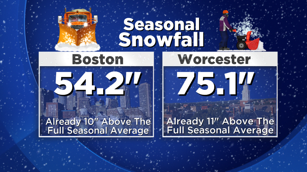
So what happens when all is said and done? Let's say that Boston gets a foot of snow. That would bring the seasonal total up to 66". When we top 71" (and I do think it will definitely happen) we'll be into the Top 10 of all-time snowiest winters in the city with a lot of time still on the clock. It's not out of the question that Boston gets to this club by Tuesday morning.
Unfortunately, there's very little opportunity for melting after the storm. Highs should stay in the 20s/low 30s for Tuesday through Thursday. Even more remarkably, models are bullish on some extremely cold temperatures moving in by Thursday afternoon. Those projections tend to moderate a little bit over time, but even if that's the case we could be looking at record cold Friday-Sunday next (Valentine's Day) weekend. We may be talking about highs that could stay in the 0s/10s and subzero temps at night.
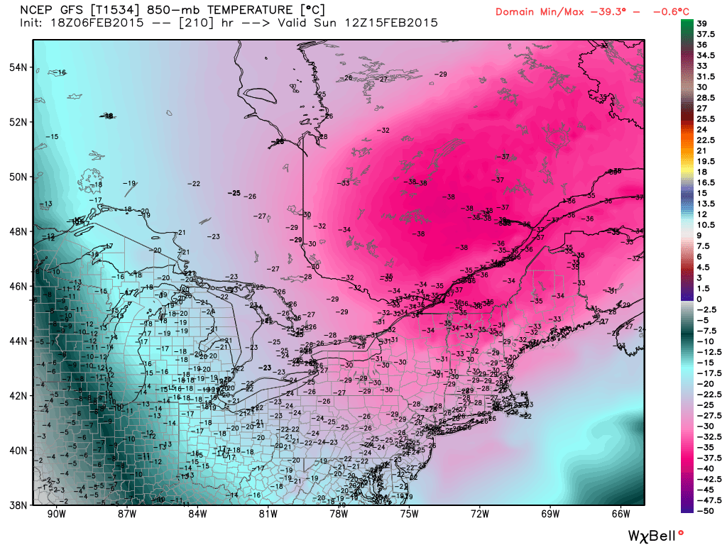
GFS forecast 850mb temperatures next weekend. Likely won't turn out quite this bad, but all signs point to an extremely cold air mass. Source: Weatherbell
Believe it or not with all this frigid talk, we've turned the corner in terms of temperatures in daylight. Average highs and lows are on the rise. And I'm sure you've noticed the increasing daylight! We've gained more than an hour since the solstice, and will gain yet another hour by the end of February. Right around the corner from that is Daylight Saving Time and much later sunsets. So there are some marker posts that we've passed. While February is looking consistently cold and stormy pretty much as far as the eye can see, we know that it can't last forever and the warmer air is drawing closer by the day.