A Quiet Stretch - Then Christmas Week Storminess
Find Eric Fisher on Twitter and Facebook
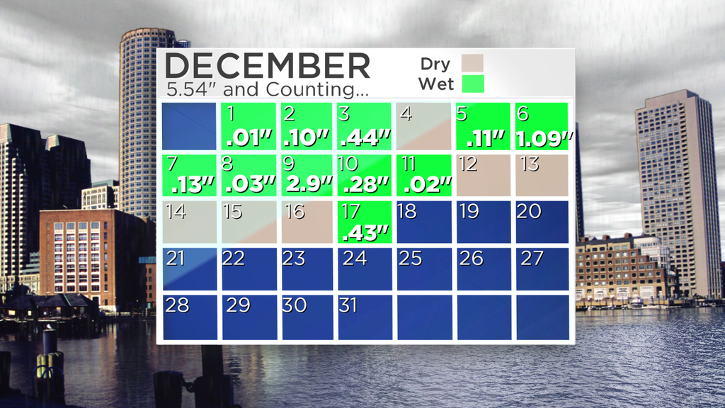
Seems like stuff has been falling from the sky a lot lately. In fact, it has rained or snowed in the Boston area 11/17 days so far this December, with over 5.5" of precipitation adding up in the city. Imagine if that was all snow! Alas for snow lovers, it's been mostly rain unless you live well into the interior. Then of course there are those who say 'you don't have to shovel rain!' which is certainly a valid point. In any case, the storms have been more wet than white and it looks like the next couple will feature more of the same.
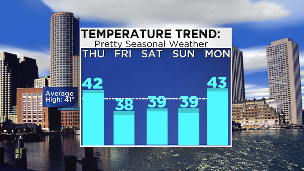
Before we get to more unsettled conditions, the weather will be fairly quiet for the next few days. The only issue today is for a couple early morning rain/snow showers (particularly north of the city) and a gusty wind which will make it feel quite a bit cooler than what we saw yesterday. Gusts out of the WNW should be in the 20-30mph range, plus temps will be a good 5-7º cooler than Wednesday. The good news is we'll work in more sunshine than Wednesday with overall partly sunny skies.
Chilly but typical December air returns for Friday and Saturday - a couple good days for running holiday errands. Skies will finally truly be bright again on Friday with a brisk breeze, and early sunshine should give way to later day clouds on Saturday to kick off the weekend. If you're traveling or have holiday parties to get to, there shouldn't be any issues at all.
The system we've been keeping track of for Sunday is looking less interesting for sure, as the overall pattern looks flat and the 'storm' weak. An onshore flow should at least bring lots of clouds and a smattering of rain/snow showers Saturday night through Monday morning, but at this point it definitely does not look disruptive.

The potential Tuesday setup as seen by the GFS model. A low near the coast may toss some more rain our way. Source: Weatherbell
That brings us up to Christmas week, which right now is the most intriguing part of the forecast. For starters, we'll have that weak onshore flow bringing clouds and a few rain showers Monday. Another wave of low pressure develops off the mid-Atlantic and may bring a round of rain yet again on Tuesday. At the very least, temps in the 40s and considerable clouds look like a good bet. But the main issue may be on Christmas Eve.
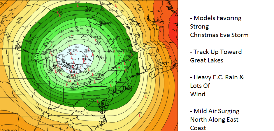
The current prognosis is for the jet stream to become more amplified again, digging deep into the central U.S. In response to this, a strong storm is likely to form and move up toward the Great Lakes. If you're a snow lover or enjoy a White Christmas, this is not the scenario you want to see. But as it stands, it's the most likely one. This storm may undergo 'bombogenesis' over land, which is certainly more rare than the typical cases we see over the Atlantic. Such a deep area of low pressure would be a big wind producer, which is probably going to be the most disruptive element of this storm. Lots of family and friends heading to airports and wind is not a friend to air traffic controllers.
If it does indeed take the 'inside' track, snow is not going to be a feature for many. In fact it is more likely to bring a surge of mild air to the eastern U.S. - a windswept, mild, Christmas Eve. There's just something wrong with that! We may see some towns up into the 50s. Odd to think many of us woke up to a White Thanksgiving, but it may be 20º warmer for Christmas Eve.
In any case it is of course almost a week out and there is a chance the track could shift. I wouldn't be surprised if subsequent model runs showed more of a transfer of energy toward the coast. That being said - snow still looks pretty unlikely for us. There would have to be a seismic shift in the expected pattern to bring it into play for Southern New England. *Maybe* the track will change enough to salvage ski country. Fingers crossed on that one. Just hoping that winds won't turn damaging, and that's where a lot of the focus will be in the days to come.
NOTE: The madness is already well underway with this storm with some ridiculous headlines, etc. Honestly a storm in late December that brings rain and a lot of wind - sure it could lead to some issues. But without a ton of snow involved the impact shouldn't be *that* big. It could be an impressive system, but 'Santa Bomb' seems a bit much. Weather has really gotten out of control on the internet these days.
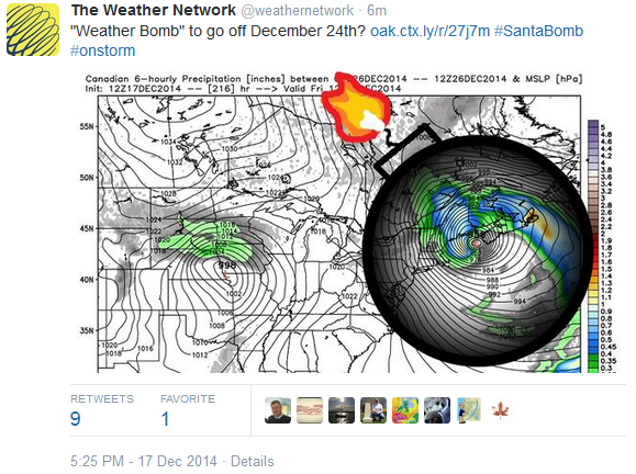
For real? Fear not, New England is not going to explode on Christmas Eve.
What happens for Christmas Day and beyond has a lot to do with where exactly this big storm forms. As you may have noticed over time, very powerful storms have a way of jolting the incumbent weather pattern, and this one should do the same. If it tracks well to our west (say, near western Michigan) it won't do a great job as pushing very cold air into our neck of the woods. We'll cool down, but nothing dramatic. The core of arctic cold will impact more of the central U.S. in its wake. If it ends up tracking farther east and near the seaboard, then we could end up with a much more significant cold shot here in New England (and that could include Christmas Day). The confidence in how it will pan out that far in advance is low at this point, but I'd favor the cold a little farther to our west. In any case stormy weather for the Lower 48 is looking like a good bet to close out the month.


