Weekend In New England
 The atmosphere was sufficiently cold to initially support a brief burst of snow before switching to ice pellets and freezing rain last evening across northern MA. It became rather slippery in places in the Route 2 corridor but, thankfully, there was not enough freezing rain to cause any significant ice accretion and power outages. Slow warming above freezing produced improving conditions and now we are faced with periods of rain today and tonight. There should be some spells with no rain falling as temperatures rise to near or slightly over 40 near the NH border to about 48 in Boston to 52 on Cape Cod. Some snow may continue to fall over the northern mountains.
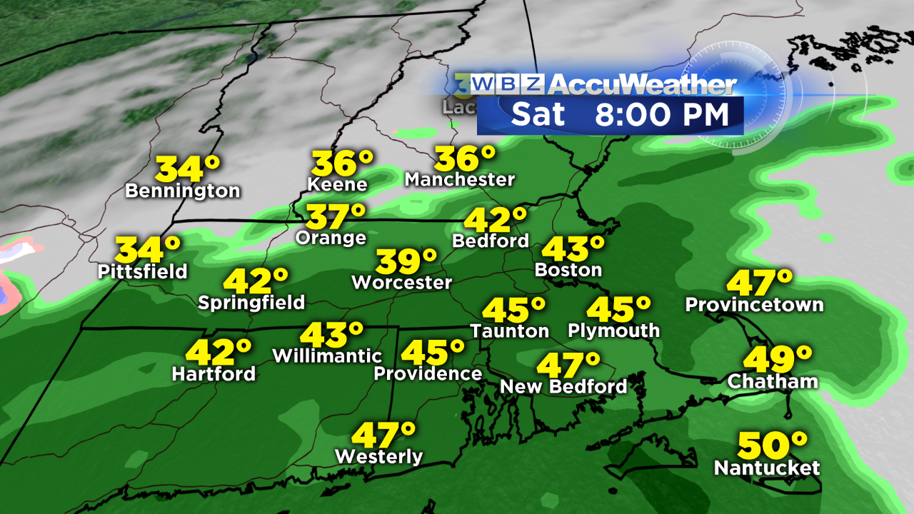 Rain fills back in across southern New England late this afternoon and evening. The final shield of rain will begin to shift southeastward during tonight into early tomorrow as the back edge exits Cape Cod around 8am.
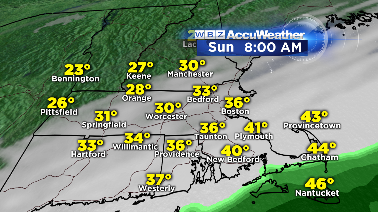 The temperatures will continue to fall a bit tomorrow morning especially over southeastern MA as a gusty cold north-northeasterly wind blows at 15-30 mph throughout the day. Afternoon temperatures will be closer to 30 near the NH border to 33 in Boston to 37 on Cape Cod. A zone of high pressure will be strengthening over eastern Canada and the Maritimes and that will feed cold air into New England on Monday with highs barely up to 32 degrees. As the cold air flows in over the relatively mild ocean, lots of low clouds will roll in and perhaps produce some ocean-effect flurries Monday afternoon. Meantime, energy diving southeast from over the Great Lakes will trigger storm development off the Carolinas. The evolving closed upper level low pressure system should capture the surface storm and propel it north-northeastward toward eastern Long Island. This suggests a flood of mild air will rush in from the ocean to create more rain than snow in eastern sections of New England. Presently, it appears the main threat from heavy wet snow will be over parts of western and northern New England into NY and PA. As the storm whirls around, colder air will be entrained into the system and it is possible that a period of accumulating snow could impact eastern New England on the back side of the storm late Wednesday.
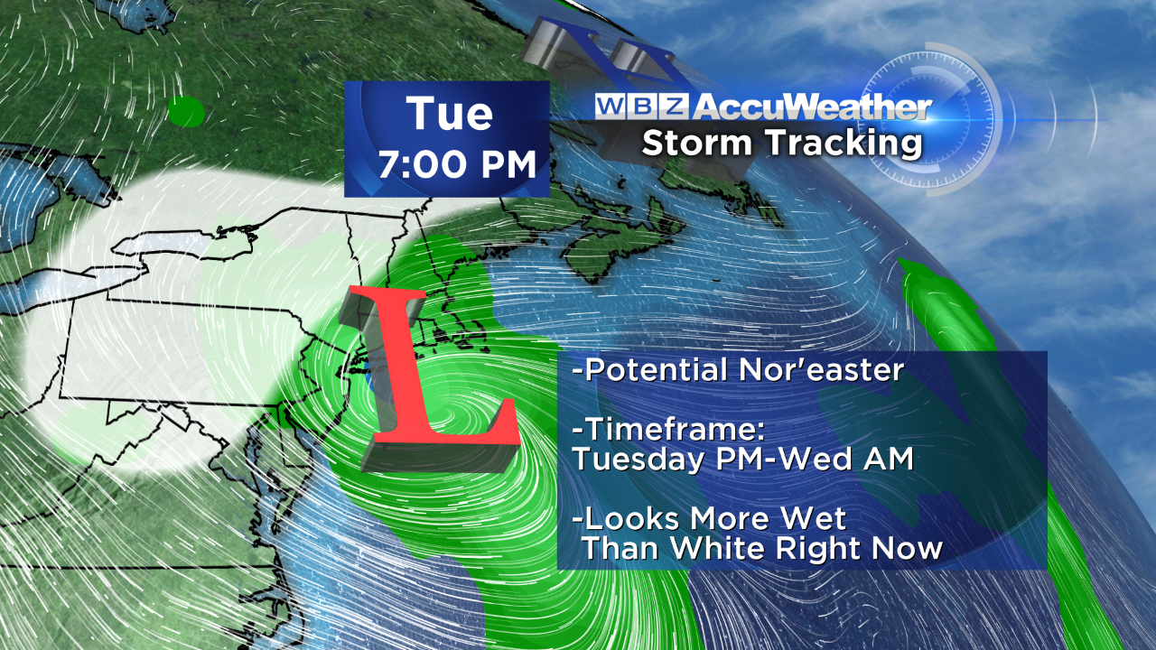 Confidence is now high that a storm will occur but the specifics are still a bit sketchy. There is plenty of time to shift the rain/snow line but the odds favor a storm tucked closer to the coast rather than offshore at the so-called 40/70 benchmark.
Last evening, I researched some data pertaining to November snowfalls. Most Novembers do not produce anything more than a trace of snow in Boston. Since 1987, there have been 7 Novembers with more than an inch including this November when Boston got 2.6" during Thanksgiving week. Check out the others in the group and notice the seasonal total for each of those Novembers.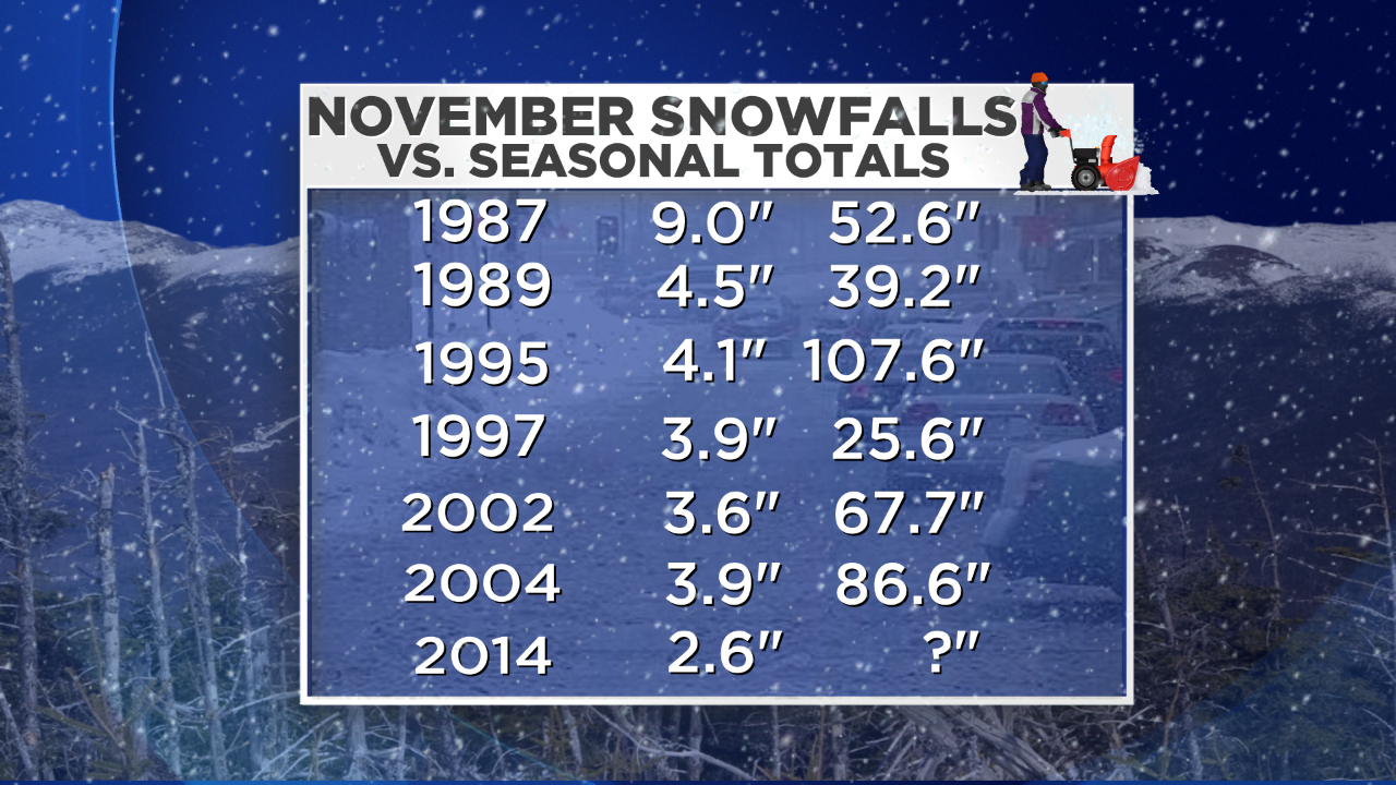
Most of the Novembers with snow ended up with snowier than average winters especially 1995-96 which is the all-time record for Boston. The stats seem to favor a snowy winter ahead. The reactions of the cycles and oscillations between the oceans and the atmosphere yield different sets of global factors that create our varying weather trends every year. Most of the analog years with the present global factors in play did yield above average snowfall. If that verifies this time around, it will be the third consecutive above average snowfall year and that has not happened since 1975-76 (46.6"), 1976-77 (58.5") and 1977-78 (85.1") Additionally, it would be the 4th out of the last 5 years with above average snowfall. This previous occurrence was in 1992-93 (83.9"), 1993-94 (96.3"), 1994-95 (14.9"), 1995-96 (107.6") and 1996-97 (51.9"). We shall see.
I will return to work all the weathercasts on WBZ News tomorrow. Have a great weekend.