Super Typhoons and U.S. Cold? They're Connected
Find Eric Fisher on Twitter and Facebook
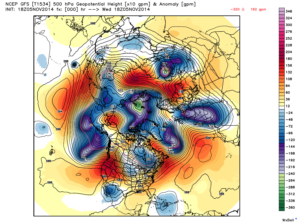
Hemispheric 500mb heights - it's all connected! Source: Weatherbell
I think my favorite thing when it comes to weather is its connectedness. This is immediately apparent when looking at a full-disk satellite image or (if you're a heavy user) hemispheric weather models. But knowing that we're all in it together, that a storm across the world can impact us, is really what the heart of weather and planet is all about. A butterfly flaps its wings in Africa and a thunderstorm pops in Asia? Perhaps. But it's clear that local events can have downstream impacts. And that's a big focus right now from the Pacific to the Atlantic.
 Water Vapor Loop over Nuri
The centerpiece for this is super-typhoon Nuri, which is now weakening and dying in its tropical state but just about to begin its journey as something else. At one point Nuri was gusting over 200mph in the western Pacific, off to the east of the Philippines. This put it up there with super-typhoon Vongfong earlier in the season as a contender for strongest storm on Earth in 2014. Typhoons (hurricanes) are warm-core systems, meaning at their heart they are heat engines - warmer at their centers than their mid-latitude counterparts - extra-tropical storms. A storm like a nor'easter is cold at its core. Both can have similar impacts, but they're running on different fuel.
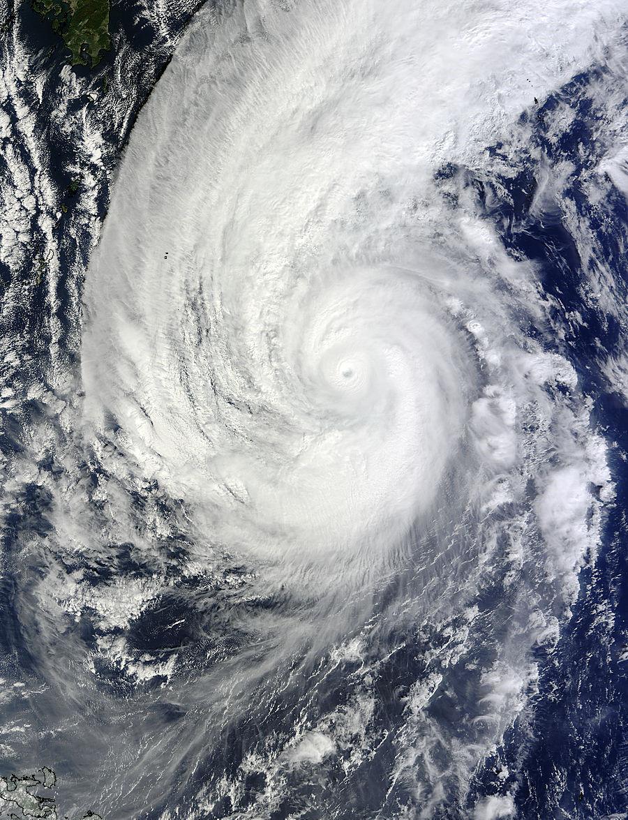
MODIS satellite image of super-typhoon Nuri near its peak intensity.
Powerful storms like Nuri can add their tropical energy to the jet stream as they move north into the prevailing westerlies. We saw this during Sandy. A storm that was once purely tropical started interacting with colder water and jet stream wind forces, and it grew in size as a result. Nuri will see the same impacts as we head toward the weekend. It'll meet up with a powerful 'jet streak', essentially a fast patch of jet stream winds. This will help the storm to grow again, and it's expected to be a monster.
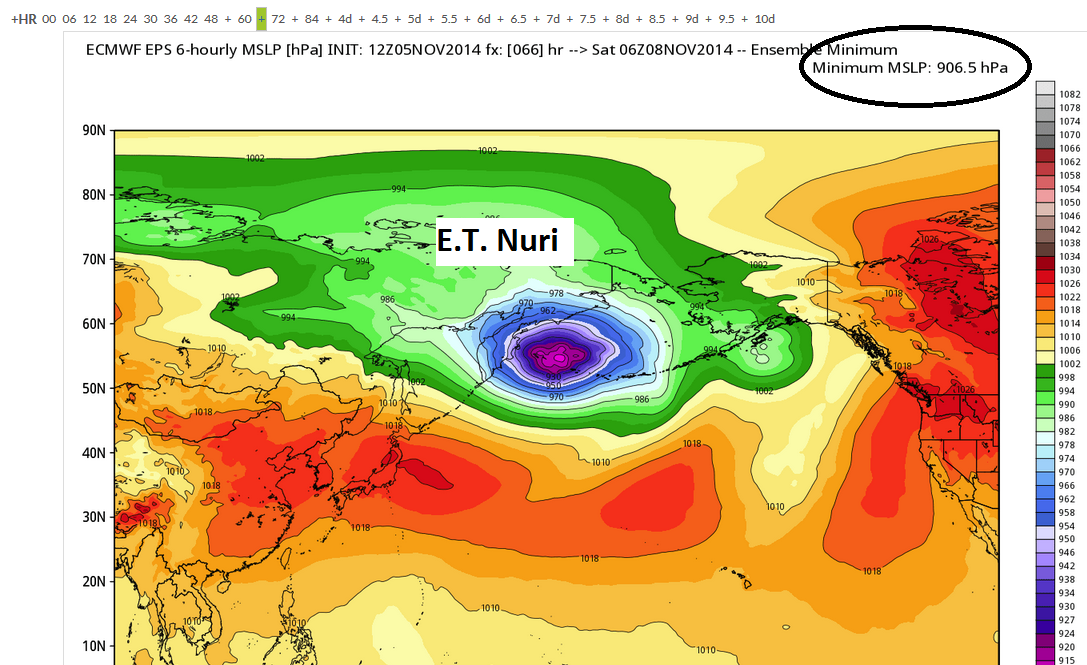
12z ECMWF EPS look at Nuri. Looking at its ensemble members, the minimum forecasts a mean-sea-level-pressure of 906mb! It likely won't get quite that low, but anything close would be record-shattering. Source: Weatherbell
By the middle of the weekend, this new version of Nuri may test the record books as the strongest extra-tropical cyclone ever observed. Computer models have consistently produced some eye-popping numbers for where it will reach its max intensity, ranging from the 900s to 920s (millibars). For reference, the strongest extra-tropical storm ever recorded is ~913mb (records aren't *great* for this type of measurement, but it's a good approximation). That storm was in the North Atlantic in 1993. This forecast storm may get close, and in any case will be absolutely superlative for the North-Pacific. It's also worth noting that tropical systems have reached the 800s when it comes to lowest pressure (mb) - but as noted above they are different animals.
Where will it land in the record books? The Washington Post's Capital Weather Gang takes a deeper (no pun intended) look: "Bombs away!"
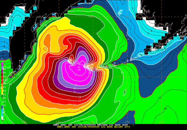
Forecast wave heights from NOAA's Ocean Prediction Center (WWIII model)
It won't just be out over the ocean - this beast will pummel the Bering Sea and the Aleutian Islands of Alaska. The Ocean Prediction Center is expecting 55' waves to rear up in an angry sea. Can you imagine being on one of those 'Deadliest Catch' boats during that kind of event! Boggles the mind to even think about. Winds will be well in excess of hurricane force to go along with that surf. Yes, it's a fairly rural area. And yes, big storms typically lash this part of the world in autumn/winter. But it will be interesting to see if this can bottom out as the strongest we have ever observed in our oceans.
Weather extremes in the Bering Sea - Historical storm expert Christoper Burt takes a look back: Big storms in Alaska's history
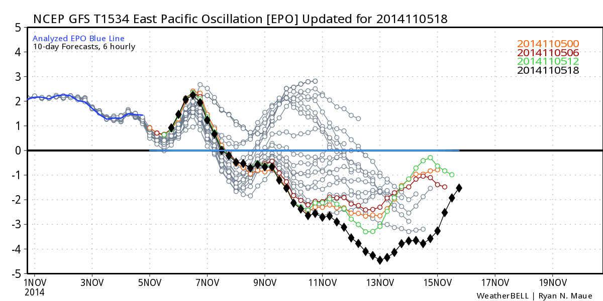
Eastern Pacific Oscillation absolutely tanks by early next week. Source: Weatherbell
So what does this have to do with us? Well gigantic storms like these can really throw the jet stream for a loop, buckling its flow downstream. In this case, it will help push a large ridge up across the western part of North America. That means warm and dry weather for the western United States/British Columbia. And to the east? A major cold plunge. This should start by early next week, and by the middle of it the cold will have seeped across all the U.S. east of the continental divide.
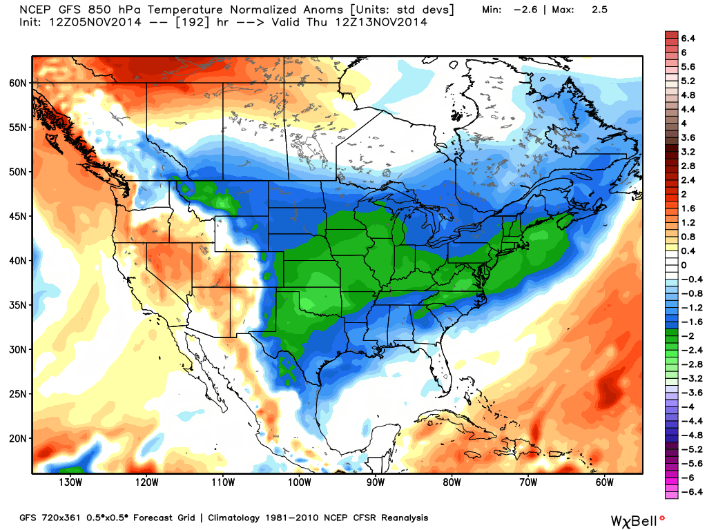
GFS forecast 850mb temperature anomalies by Thursday morning. Cold everywhere! Only the west coast looking at warmer temperatures. Source: Weatherbell
How cold? Well this shot may rival or break the one we saw last week after our nor'easter. That outbreak of cold broke records in the south and brought the 40s all the way down into south Florida. This one may be directed a little farther west, starting across the Plains and the Front Range of the Rockies. But eventually wintry air will envelop all of the east. We'll be on the fringe of it, so our departure from average won't be quite as impressive. Even still with so much cold around, the chances for a snowy event in the east will go up as we head toward the end of the week/weekend.
In the end, it's amazing to watch all these forces at work. Imagine 60 years ago, when none of this was possible! You might hear about a storm somewhere else in the world, but now we watch it with satellites and computer databases. You can forecast a cold plunge in the U.S. a couple weeks in advance simply based on the knowledge of a developing super-typhoon near Guam. Will be interesting to see how cold the final product ends up being!
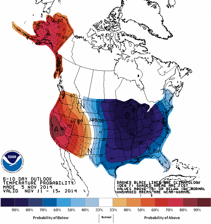
Chances for above/below average temperatures next week from the Climate Prediction Center. We're not in the heart of the cold locally, but will get chilly.


