November Unfolds

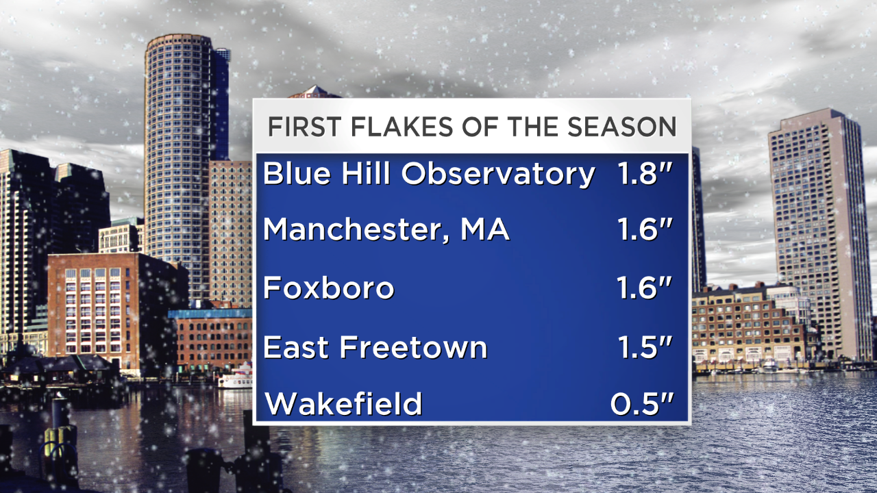
November is here with a vengeance. Its debut lived up to its reputation of being a bleak month in many more ways than one. Tree defoliation, disappearance of any remaining flowers and crops, dropping temperatures and sunsets before 5pm is all downright depressing. Statistics reveal that November, on average, is the cloudiest month of the year. This year, the 11th month of the year was introduced by a nor'easter coincident with the ending of daylight saving time. Now that is a rather ugly combination! This weekend was the first one since the weekend of March 1 and 2 that the temperature failed to reach 50 degrees in Boston. On top of that the region received its first flakes of the season amounting to a trace in Boston and other locales but ranging up to 2" or more whitening the landscape over eastern and especially southeastern MA excluding much of Cape Cod.
 It could have been worse or better depending upon your point of view. Downeast ME was slammed by a blizzard with snowfall amounts of more than a foot in places such as the Boothbay Harbor/Camden area that measured near 18". It was a heavy wet snow resulting in widespread power outages and tree damage.
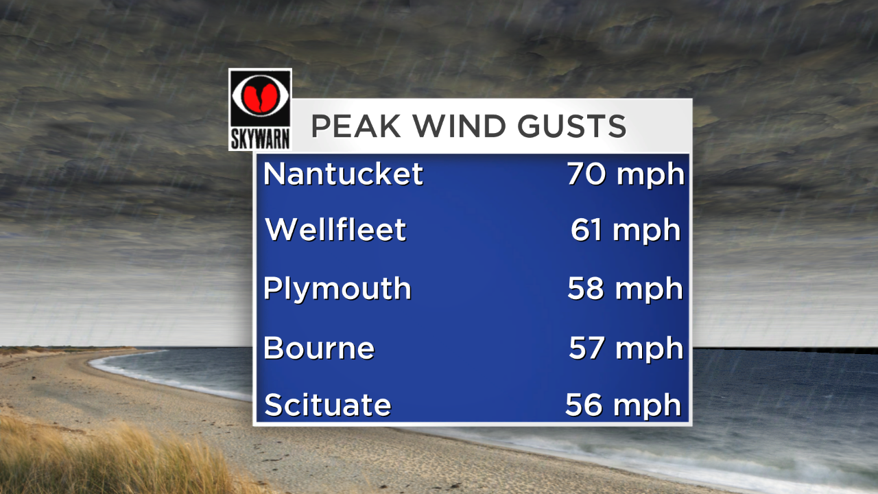 Howling winds produced the most havoc closer to coastal locations and the intense storm centered offshore by about 150 miles cranked the seas into an angry chaos resulting in beach erosion and some wave battery. Minor flooding with pockets of moderate flooding closed roads. As the storm churns up over the Canadian Maritimes, the wind will gradually relax but remain brisk through Monday. The return of dry air will create plentiful sunshine and boost temperatures to the upper 40s. The wind will be relatively docile Tuesday through Thursday then turn gusty again later Friday through Saturday.
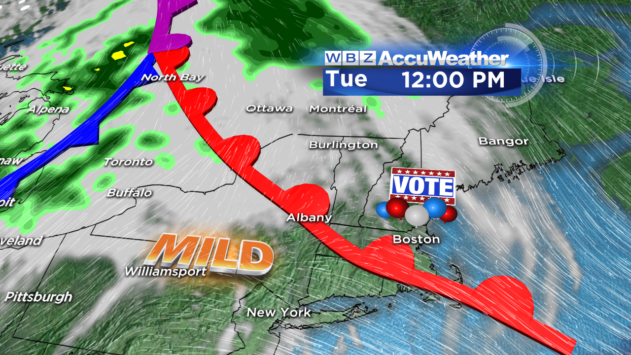 Election Day is Tuesday and the weather will be cooperative for you to get out and cast your vote. A warm front will be approaching and slowly lifting through the region during the day. The only consequence will be some attendant cloudiness at times with temperatures rising into the lower to middle 50s. No rain is anticipated from this front. Additionally, I am not expecting any rain associated with a cold frontal boundary passing across the region on Wednesday. It should warm up to the lower to middle 60s before the frontal passage as varying amounts of cloudiness will be seen in the sky. After that, a spell of wet weather beckons as yet another system dives from the Canadian Rockies southeastward into the Ohio Valley yielding a developing primary storm with a secondary spinoff over Delmarva. This setup is destined to deliver some more copious amounts of rain Thursday into Friday.
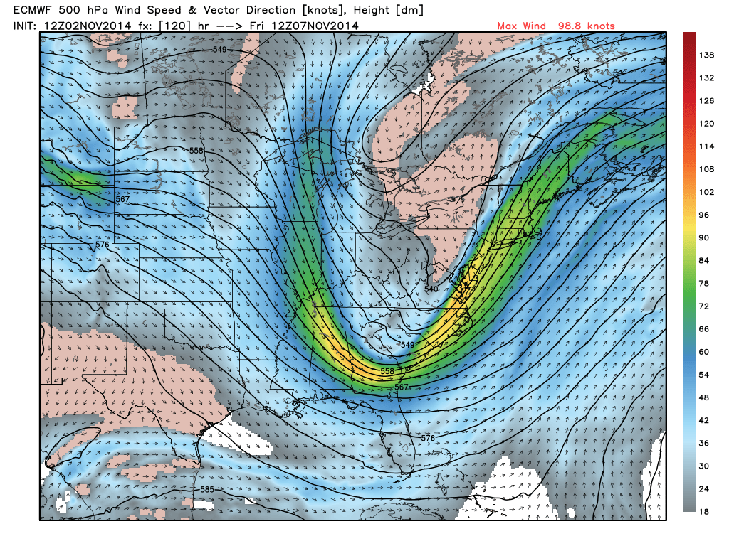 The recurring pattern over the past couple of weeks may be an important clue about the flavor of the upcoming winter. There are many factors in alignment to generate a rough season ahead. The WBZ AccuWeather Team will elaborate later this month as we present our winter outlook. Presently, I will just say that the potential exists for a similar or even more harsh winter than last season but there will be some differences. There is a high degree of certainty that there will not be a repeat of the pleasant benign winters of 2001-02 and 2011-12. Winter did not exist in those two years thanks to extraordinary mild weather breaking records. We all saved a great deal of money on our heating bills. Anyway, examine the map to the left and you will easily notice the deep trough in the east and a ridge out west. Several masses of polar and arctic air have already been diving southeastward from central Canada east and southeastward. The Eurasia snowfall is off to a very early start which is a good clue. North Atlantic blocking was practically nonexistent last winter but is likely to be more of a key player this winter due to supporting factors. That is just the tip of the iceberg so to speak. Whatever the weather, it always creates mixed emotions because people like different kinds of weather. I suspect that many more people would enjoy an easy winter like we had 3 years ago but there are many folks who look forward to winter sports. Admittedly, I enjoyed that warm winter but I also like snow and cold especially if it's up in the mountains. Details to come!
Credit: WeatherBell
You can watch the weathercasts of Danielle Niles on WBZ News Monday morning followed by Eric Fisher on the evening news. Make it a great week!