Tracking The Weekend Cold Blast & Potential Storm
Find Eric Fisher on Twitter and Facebook
We're one day closer to the weekend and there's been a lot of buzz going around as we approach a chilly blast of air, so I wanted to put down an update to Monday's blog post. While 24 hours have passed and we've seen a lot more data, there are still a ton of questions and only a few answers as to how this weekend will play out. First, a disclaimer. I've seen at least one station (not in Boston) put out a snow forecast map for Sunday. Folks, it does not work that way. You cannot forecast snow totals that far in advance. Weather prediction and technology, as it stands now, doesn't allow us to make any sort of bet like that with any useful precision. So please know that anything you see like that when a potential storm is 4-5 days away is, at best, a blind shot in the dark.
What I and the rest of our team try to do with these blogs is put out advance notice of changes in the atmosphere ahead. Some of these are obvious and can be seen a couple weeks or more in advance. Others are a lot more nuanced. In general, it's a LOT easier to forecast temperatures in the long range. Actual storm tracks and intensity are another matter. For tropical weather it's a similar story. We can see high probability of tropical development way down the road by looking at long-range shear potential, water temperatures, and phases of the MJO (Madden-Julian Oscillation). Even the tracks are usually *excellent* now with impressive lead time of 4-5 days in many cases (some even longer). But it's the intensity that's key to impact. That's what makes a storm forecast difficult - when it's actually game time a lot of little differences can have major implications, and they're all happening on a much tighter scale of time and space.
That being said, let's start off again with what we DO know about the upcoming change in our weather....
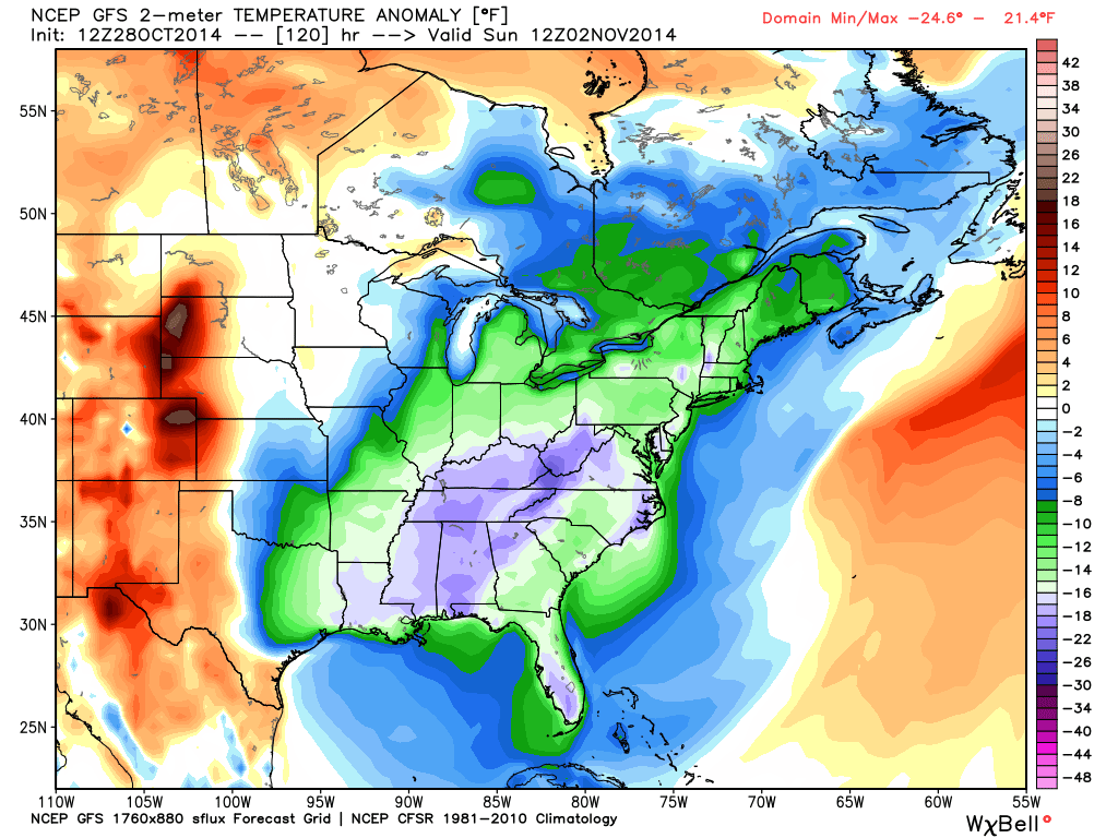
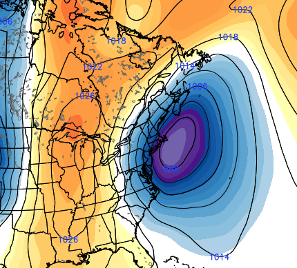
12z GFS forecast temperature anomalies for Sunday morning. Huge area of 15-25ºF below average temperatures, focused on the southeast on Sunday. Our departures in New England are more like 10-15º below average on Sunday. Source: Weatherbell
As stated for the past 5 days or so, I'm expecting a big blast of chilly air to seep into the eastern U.S. starting on Friday. Much of the Midwest and Southeast will be seeing temps 15-25º below average, all the way on down into Florida! Highs in the south this weekend will stay in the 40s & 50s for most, and just make the 50s & 60s in Florida. Hey, that's cold by their standards :-)
For us, cooler air will start to trickle in Friday, keeping us in the low/mid 50s. Not too bad. On Saturday more of that cold air works in but we won't have our toes dipped all the way into it yet. Highs will be mainly in the 40s, possibly near 50 along the South Coast. But the real blast plunges in Saturday night into Sunday. Highs for the second half of the weekend are going to stay in the 30s and 40s, well below average for this time of year.
There's also of course going to be some 'hang by the fireplace' conditions at night. If it's damp outside Saturday night, some areas may drop to cold enough levels to see icy spots develop. The ground is still warm, but if we can drop air temps into the 20s it may be enough. That' s a situation we'll monitor as we get closer. Sunday night looks much colder with widespread 20s. By all accounts, it should be the coldest night of the season so far with a widespread hard freeze.
We also are very confident that it's going to be a windy weekend. Regardless of where our potential storm forms, there will be a lot of cold air mixing down on gusty winds and a tight gradient between the storm and strong high pressure building in from the N/W. Would expect gusts somewhere in the 20-35mph range Saturday, but may increase to the 30-45mph range Sunday. That is dependent on how close/strong the storm becomes as it develops off the coastline.
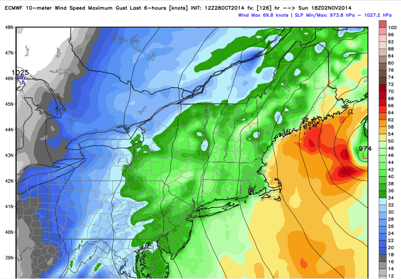
ECMWF forecast wind gusts on Sunday. With a strong low to the east and a strong high to the west, the gradient should be tight and the wind will add to the chill (in fact I'm thinking we will be dusting off the 'wind chill map' on Sunday!) Source: Weatherbell
And it's also clear that the cold air outbreak won't last very long. We're talking Saturday, Sunday and Monday. All indications are that as we head into next week, the pattern will warm right back up across a big portion of the country. Not thinking we'll get into the real center of that warm air, but it will at the very least return to average, if not a bit above.
Here's what we DON'T have high confidence in yet...
Where is this storm going to set up? As mentioned above, there's still a very wide spread. I don't think a storm *not forming* is an option. With a ton of jet stream energy, possible phasing of the northern and southern streams, and a tight baroclinic zone (meaning, a wide temperature spread over a short distance) it would be pretty near impossible to keep a significant storm from developing.
We as meteorologists look at a number of different computer models on a daily basis. Some are better than others, some have 'off' periods where they don't perform well, some are better in certain time ranges, and most importantly of all we have whole sets of 'ensembles' to look at. What I'm telling you is, we spend way too much time starting at a computer screen. New data is pouring in all the time we when the pattern is busy I don't miss a run. You need to be able to monitor trends over time.
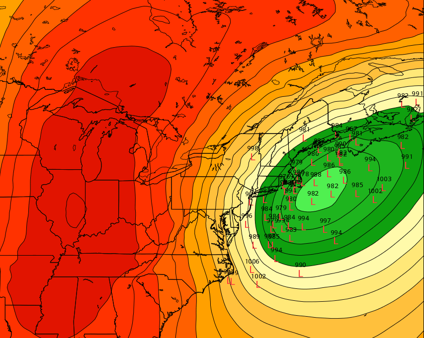
12z ECMWF EPS mean low pressure anomaly for Sunday morning. In essence, the ensemble mean is showing the highest probability of a low pressure center near the benchmark (40ºN 70ºW). That's a prime location for New England rain/snow. Source: Weatherbell
The ECMWF - or 'European' model you've probably heard about is the most bullish on an impactful storm for New England. Not only is its 'operational' run closest to the coast and most intense, but its ensemble members are generally in agreement. The 'ensemble mean' shows essentially a benchmark nor'easter - which would bring a variety of rain, snow, and wind to eastern New England.
12z ECMWF ensemble members plotted out for Sunday morning. I included this in Monday's blog and you can see that they've started to tighten up a little bit. That's good - it shows increasing certainty. However the 'bulls-eye' is elongated out to the northeast, which suggests the potential is still there for this storm to escape east of us with minimal rain/snow. Source: Weatherbell
The GFS is pretty much a complete miss. That's a scenario that is certainly still in the cards. While it develops a similar deep eastern U.S. trough as the ECMWF, it keeps the flow more progressive taking a weaker storm farther out to sea in a quick manner. The ECMWF trended a *little* more progressive Tuesday vs Wednesday, but not much.
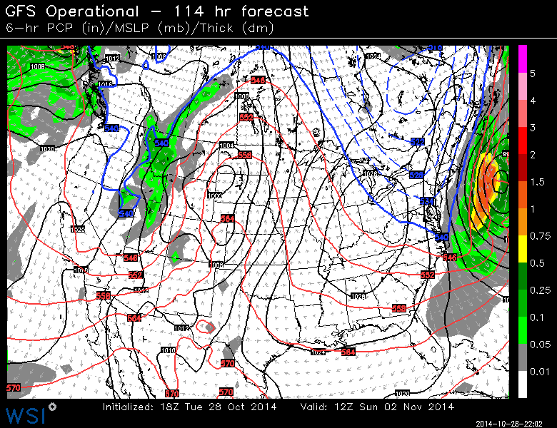
Currently, the GFS is out to sea with this one. Source: WSI Energycast
THE JMA (Japanese model) is close enough to the New England coast for impact...and the Canadian GEM is close enough for at least a glancing blow.
When putting together my own thoughts for how this will pan out, I try to look at all these scenarios and deem what's most likely given what the overall pattern looks like and what's happened in a similar situation in the past. So that being said, I'm leaning more toward the ECMWF, which would produce a stronger storm a little closer to our coast.
Timeline
On Saturday, I'm not expecting any flakes during the day. As the trough digs and energy starts to transfer from the Great Lakes to the mid-Atlantic coastline, we'll be on the northern end of all the action. So we may get some rain showers/periods of rain, plus a gusty breeze and chilly temperatures. Travel should be fine, and evening plans should be fine as well. As temperatures begin to fall, we *may* be able to mix in some wet flakes for the higher elevations at night. That's the kind of detail that will come into better focus later this week.
Late Saturday night and early Sunday is our main window for any potential 'impact.' We know the temperatures aloft will be plenty cold enough, and the surface will be cooling down into the 30s too. The storm shouldn't be too slow of a mover, so by the evening I'm thinking that *if* we're dealing with any significant precipitation..it will have cleared out. And at this point I don't think any rain/snow is going to be an issue for the Patriots vs Broncos game. Just a cold, windy AFC grudge match.
The Takeaway
Reading from Connecticut, WMass, or Vermont? Not expecting any significant impact from this potential weekend storm. Whatever forms is likely going to be too far east, and high pressure quickly building in from the west is going to drive drier air in.
Reading in Rhode Island or central/eastern Massachusetts? You should just stay up to date with the forecast over the next several days, as it is bound to change. I would NOT go canceling any weekend plans at this point. There's too much uncertainty to be making definitive calls this far out.
Reading in New Hampshire or Maine? You're probably most 'in play' for this. As the low bombs out in the Gulf of Maine, it should be able to wrap moisture back into your neck of the woods (especially downeast Maine). There's some good news here - most of the leaves are gone in central/northern Maine, with a few hanging on in southern Maine. Southern New Hampshire, from what I'm gathering, is at ~30-50% leaf cover still. We'll see how many more of those fall off this week. If there's any concern with this possible event, it's the leaves. Very small amounts of snow can bring down limbs if leaves are still on...so that's something we'll continue to keep an eye on.