Sizzling September!
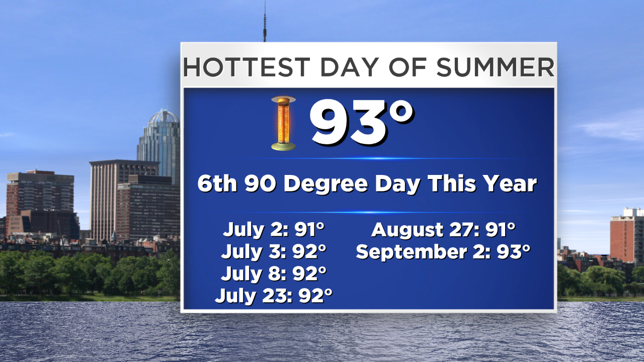
Yesterday was the hottest and muggiest day of the summer in much of the Boston area and it happened after Labor Day when teachers and students are in school! Whew! The temperature reached 93 degrees at 12:57 pm in Boston! The record for the date is 100 set in 1953. Some September days can be really sizzling especially during the first half of the month but usually it lasts only a day or two here and there. Heat waves are uncommon this month due to the jet stream shifting south resulting in more rapid weather changes enabling cooler air masses to stream out of Canada. In the past 140 or so years of weather records in Boston, there have been only 3 heat waves meaning 3 or more consecutive days of 90 degrees or higher. The most recent September heat wave was actually more than 30 years ago in 1983 on the 5th-7th. It turned out to be a record high of 94 on the 7th. That was followed by a record-smashing 99 on 9/11/83 and a stunning 97 degrees on 9/20/83! The heat was relentless in 1983 with 35-45 days at 90 or higher in the region! Just last year, it was a blazing 97 degrees on September 11th!
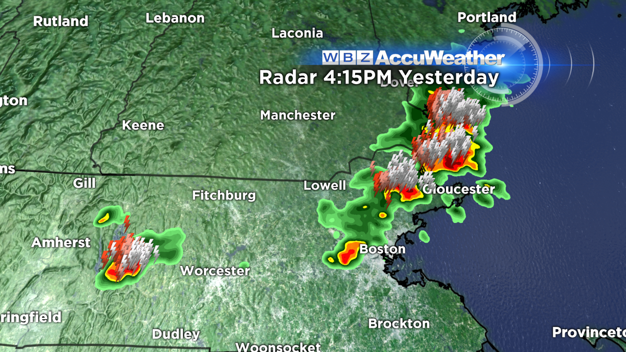 With dewpoints in the range of 70-75 creating super sticky conditions, the atmosphere was loaded with heat and humidity to fuel some nasty boomers in places yesterday. The cluster of nastiest storms clobbered parts of northeastern MA and the NH Seacoast with sheets of flooding rains amounting to 0.75-1.25" in 20-30 minutes with frequent cloud to ground lightning strikes and gusty winds of 20-40 mph. Other rough storms struck places in Worcester County into the southwestern suburbs of Boston.
A cold frontal passage early this morning is responsible for decreasing humidity as a pleasant drying westerly breeze blows. Sunshine will be prevalent today, tomorrow and Friday as a ridge of high pressure passes over the Northeast. Dewpoints will settle into the upper 50s by late this morning and stall in the middle 50s tonight through tomorrow before rising back to the middle to upper 60s on Friday. Albeit cooler than yesterday, the air temperatures will still spike to the middle 80s today and tomorrow then make a run to almost 90 on Friday!
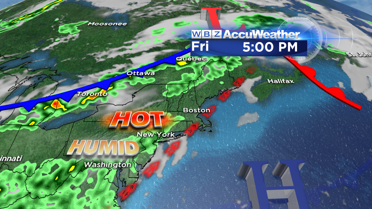 The southwesterly wind will freshen on Friday so south-facing coastal areas will be closer to 80 in the afternoon. A cold front in southern Canada will be settling southward on Saturday. There is support for showers and thunderstorms to break out in advance of the front. Some of these storms may be strong to possibly severe. If that activity is delayed until mid-afternoon Saturday, the temperature could briefly hit 90 again. If cloud debris arrives sooner, it would be a touch cooler in the middle to upper 80s. It appears that the frontal boundary will decelerate and a weak wave of low pressure could cause showers to linger into Sunday morning. It will certainly be much cooler on Sunday with highs closer to the upper 60s to near 70 degrees. Expect improving conditions from northwest to southeast across the region as Sunday evolves. High tides over the next few days will be in the early evenings and early mornings.
You can watch the weathercasts of Danielle Niles on WBZ News through 9 o'clock this morning and Eric Fisher returns for the evening shows.
Make it a great day and enjoy the drier air this afternoon!