Hail Moves Out, Wind Moves In
Find Eric Fisher on Twitter and Facebook
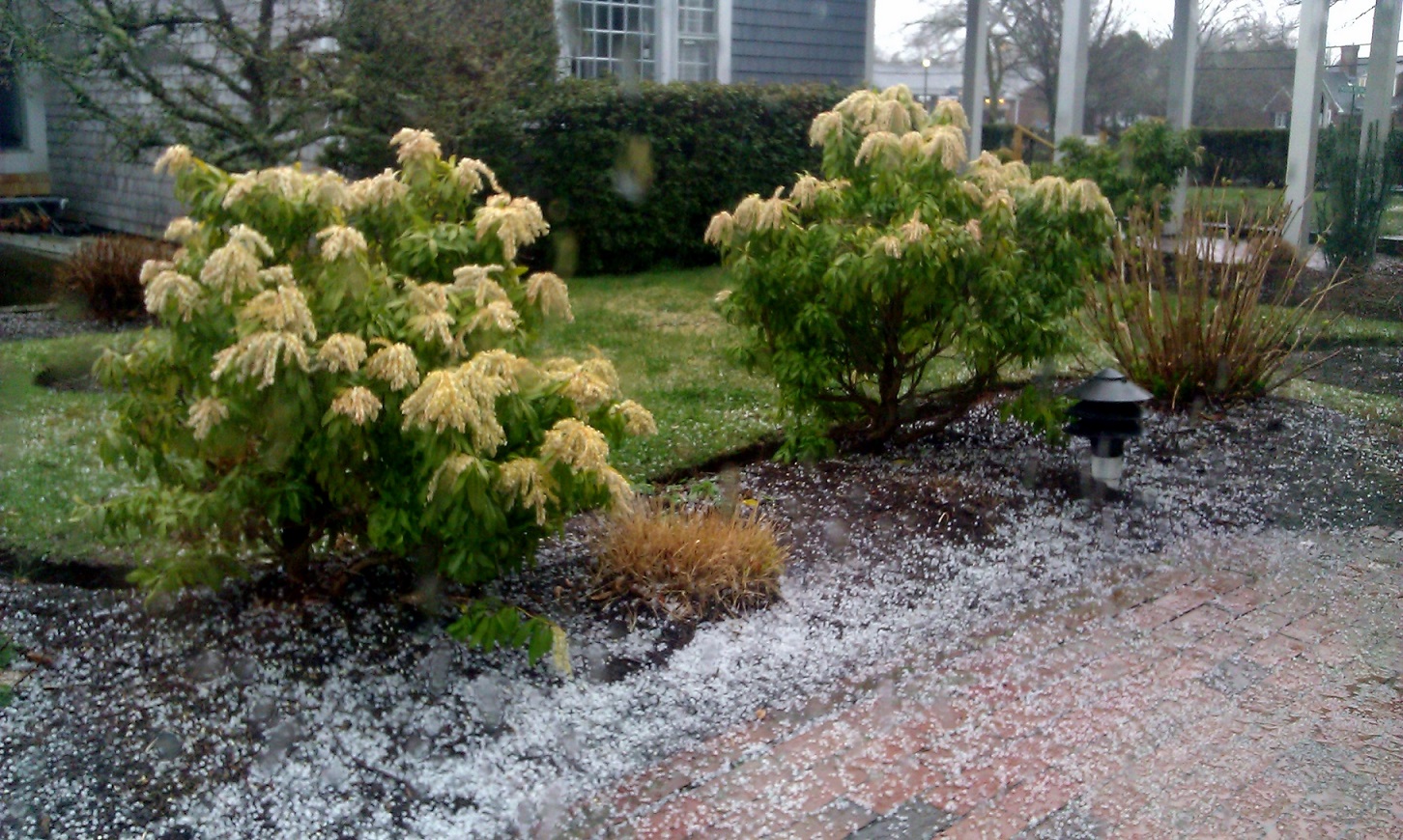
Hail stacking up in Chatham, thanks to Darlene for the photo!
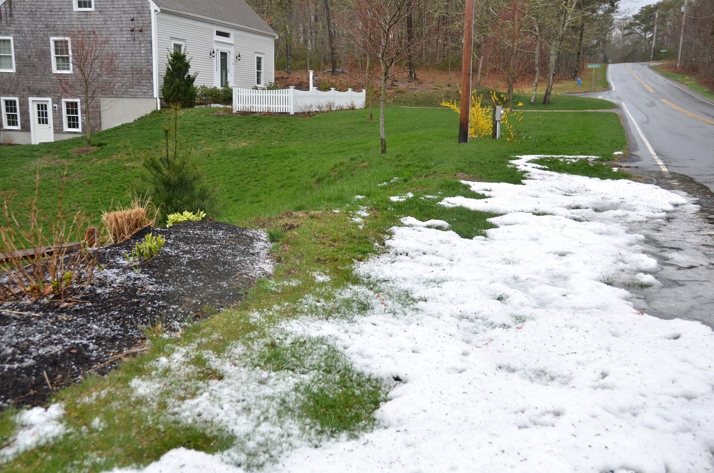
Harwich Hail from Brian Powers. The rain washed it all down toward the road, almost looking like snow. Thanks to the many who took time to send us photos today!
First of all, a HUGE thank you to everyone who didn't write in to say it was sleeting today :-) Yes, those were hailstones falling out there, particularly far eastern MA. For many on Cape Cod it was a wild scene as the ground was quickly coated over several minutes as pea-sized hailstones bounced off the newly green grass. But these weren't from your typical summertime thunderstorms. The setup today was a little different, so I thought it might be worth going over for those who are curious!
In the summer, you often generate instability by heating up the surface with strong sun almost directly overhead. The ground heats up, the air becomes buoyant (rises) and you produce clouds, eventually turning into storms. If it's cold aloft, even better. The bigger the difference between what's above and what's below, the steeper your 'lapse rate' and the more inclined air will be to rise.
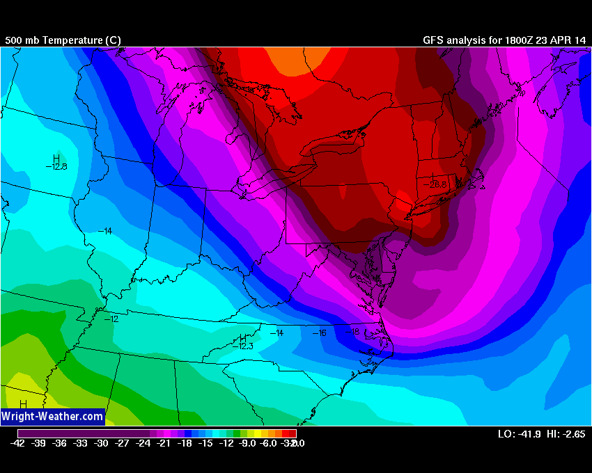
500mb temps at 2pm this afternoon. Notice the large tongue of very cold air nudging down across New England. This was co-located with an upper-level low which was swirling across MA at the time. Source: Wright-Weather
On Wednesday, we created instability by bringing in colder air aloft. A pocket of very chilly air swung overhead, and so that difference between the ground and the air several thousand feet up increased (you'll notice we didn't even really need the sun!). With an upper-low also overhead, we had all we needed to increase instability.
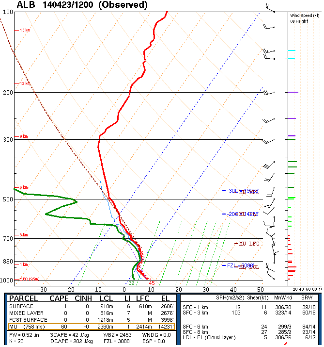
The 12z (8am) sounding out of Albany, NY captured this air mass nicely. Look how close the freezing level is to the ground...only about 3,000 feet up. So what was developing in the clouds could easily freeze, so long as it was held up for just a little bit by the rising air. Since these aren't the summer monsters that have strong updrafts capable of holding hail aloft in the clouds for a longer amount of time (making bigger stones), these maxed out at only pea-sized. But even still, an interesting spring day for sure.
UP NEXT - THE WIND!
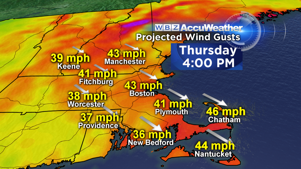
Now the attention is all about the wind. It's already howling out there, and will continue to do so all the way through Thursday night. Bottom line is that if you don't want it to go flying down the street, don't leave it outside. This goes for patio furniture, grills, trash cans, and small pets (the last one may be an exaggeration). It's also not a terrible idea to park inside the garage if you can - I wouldn't rule out some trees and limbs coming down over the next 36 hours.
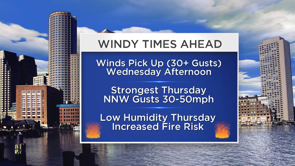
Frequent gusts between 30-40mph are likely Wednesday evening and night, perhaps helping to power some Red Sox home run balls out to right field at Fenway. If any of the lefties can pull a pitch, they'll be sitting pretty as the wind blows strongly out to right. As we head into Thursday, a tight pressure gradient will keep the wind flowing out of the NNW and speeds will actually increase to 50mph at times! That's getting to the point where some structures and loose belongings start to go flying, as well as some weakened trees. There should be no real letup from sunrise to sundown, with high temps in the 50s.
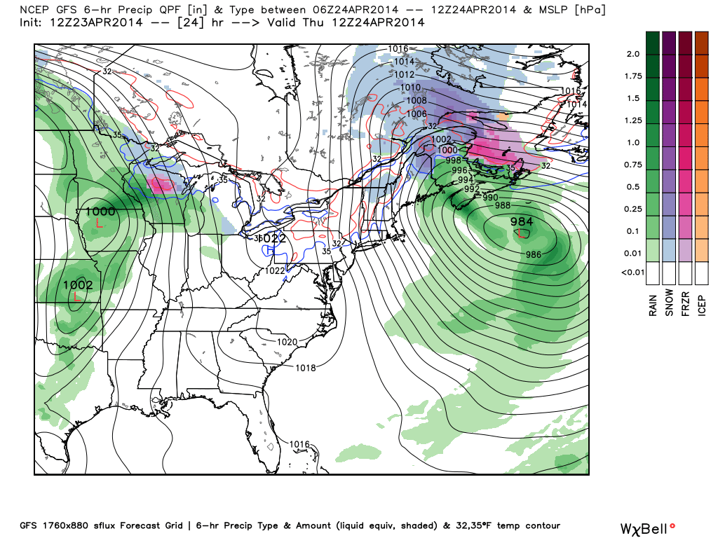
A tight pressure gradient (difference over distance) responsible for our windy woes. A 984mb low sits in the Atlantic, with a 1022mb high over the eastern Great Lakes. That makes for a gradient of about 38mb over ~1000 miles. Source: WeatherBell
Another issue on Thursday is the fact that relative humidity will be a lot lower than Wednesday. While we did pick up some beneficial rain, low humidity and strong winds can still help to fuel brush and structural fires should they manage to spark up. Not a good day to burn brush in the yard, and be extra cautious with any open flames. A Red Flag Warning may need to be posted by the National Weather Service - check back on Thursday am for any updates there.
This gradient will finally relax by Friday morning, making for a much more comfortable end to the week. Highs should be close to 60 with sunshine and lighter wind. TGIF! The next system approaches Friday night with showers, which should linger into Saturday as well.


