Mildest Weather Since October!
Find Eric Fisher on Twitter and Facebook
Oh how quickly things change. The funny thing about weather is that it's arbitrary. What's windy to one person is breezy to another. What's warm to one is cold to another. Could go on and on. It's basically a matter of opinions, which makes conveying a forecast all the more challenging. I personally thought Saturday felt great as I went out for a run in shorts and a tee-shirt. Well others felt differently. Quite a few commented on how cold it was! This came as a bit of a shock, considering it was 10 degrees warmer than Friday for most and about 20 degrees warmer than most of the days in recent memory. But as soon as the weather started changing and we went into spring, the standards started to rise. And now the 50s with wind apparently are no good anymore! You gotta love it. So my sincere apologies for anyone who was expecting a 'warm' Saturday and was disappointed. I promise, it was an above-average day for April 4th.
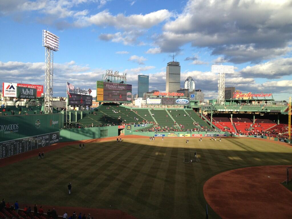
Chilly but beautiful evening at Fenway Park on Saturday
In any case, Sunday, as advertised, will certainly be better. We'll have 2 things going for us compared to Saturday - more sunshine and less wind. High pressure will nudge overhead and help to decrease the pressure gradient, meaning just a more comfortable westerly breeze than the gusty northwest one we had to put up with on Saturday. And with a more stable atmosphere and subsidence (sinking air) we'll get to soak in a lot more sunshine too. Overall a great second half of the weekend with highs again mainly in the 50s.
More of the good stuff on Monday, as highs will rise through the 50s and maybe even approach 60 in some towns away from the water. Winds out of the S will keep the immediate South Coast and Cape Cod/Islands chillier. Expecting plenty of sun to kick off the day before cirrus start to invade, and then the cloud base will lower heading into the afternoon/evening ahead of our next storm. This one has more juice to it than the one we saw Friday night, which generally brought 0.25 - 0.50" of rain. Before it arrives in New England, it will have dumped 2-5" of rain across the Southeast!
The main burst of rain should come Monday night, but showers and downpours should still stick around on Tuesday. We should be able to jump into the warm sector of this one, which means mid 50s to mid 60s for highs. What we'll most have to pay attention to with this system is the amount of rain, which should top 1" at least. The ground is still thawing out, it's pretty well soaked through from melting snow and recent rain, and rivers/streams are still running on the higher side. 'Tis the season for flooding, so this will have to be monitored. I'm not expecting anything major, but the typical nuisance minor to moderate flooding may have to be dealt with.
The coldest day of the week looks to be Wednesday and chillier air flows in behind the storm. But very quickly we'll get into 'return flow' as high pressure heads to our south, and this will pump mild air right on back into the region. Temps should be able to get up around 60 on Thursday, and into the 60s on Friday before some rain showers push through.

When you put it all together, we may end up with at least 7 straight days of highs above 50 in Boston. That may not sound like too much, but it's something we haven't done since October of last year! Yep, it's been a pretty nasty stretch. But we're definitely coming out of it, and the signs of spring will only increase from here on out. Expect to hear more peepers in the swampy areas this week, daffodils to continue reaching toward the sun, and perhaps a few early shrubs/trees starting to show the telltale signs of life.
Is it spring everywhere? No it definitely is not. The White Mountain region still has 4' of snow on the ground, with most of the higher terrain still boasting significant snow cover. In Maine, it's not any better. Interior parts of the state are completely locked in ice and snow, with Caribou seeing one of their highest snow depths ever recorded in the month of April. And the Great Lakes are still more than 60% covered in ice! That last statistic is particularly amazing...that amount of coverage is about 600% of normal for the date. So there are still many signs of the brutal winter, even as we transition to warmer times.
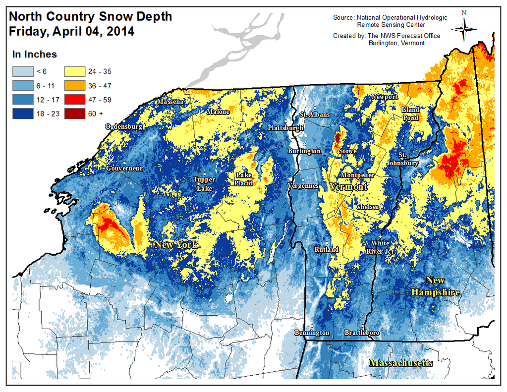
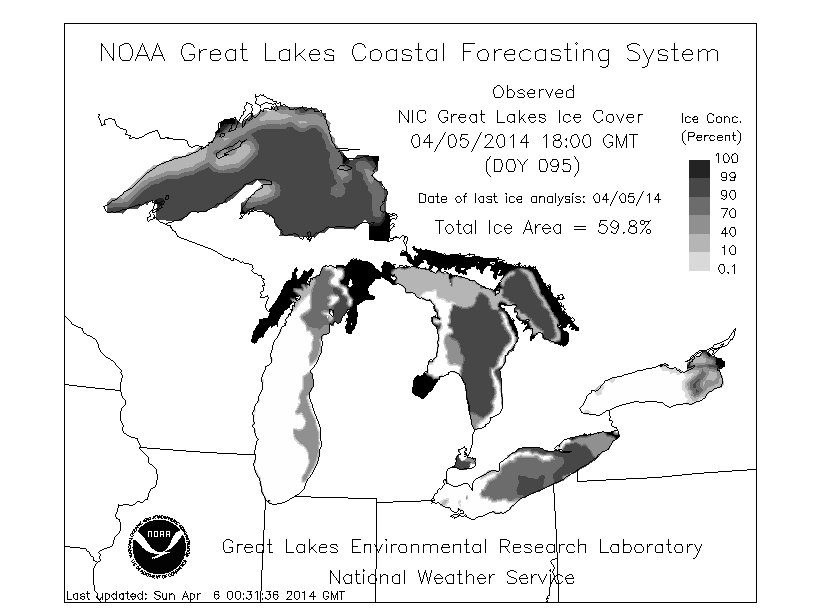
Source: NWS Burlington and GRERL