Sloppy Thursday Night
Find Eric Fisher on Twitter and Facebook
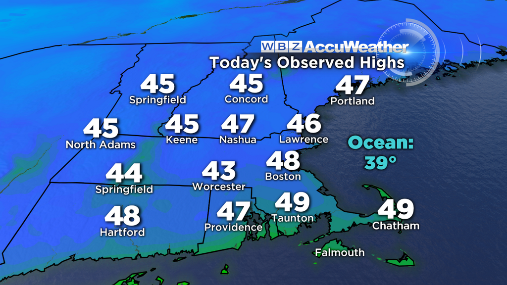
People smiling, snow melting, sun shining. A feel of spring out there today, with highs up into the 40s! You know it's been a rough stretch when the 40s start to feel like heaven, but hey we'll take it. A much needed break from a long stretch of cold days and nights. It was also a good opportunity to clear snow from vents and roof tops, which hopefully some took advantage of. Many parts of the state look like Siberia the snow has piled so high, and that can cause issues as snow adds up and has water added to it from rainfall.
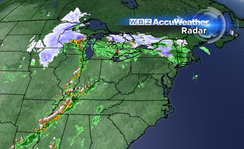
Another tricky setup tonight, with a whole mix of different conditions across the area. From 6p to 11p a band of rain and wet snow will march across New England. This band is the leading edge of lift in the atmosphere along a warm front, which stretches back to a major storm system currently occluding in the Upper Midwest. It'll bring blizzard conditions there and widespread severe weather across the Ohio Valley and Southeastern states! So overall, we're getting off easy with this one.
Temperatures at the onset are still coming off today's highs, in the 30s and 40s. But dew points are in the 20s, and wet bulb temps are in the low 30s. So as this rain falls, the air will cool down toward the low/mid 30s. Wet snow will still have a difficult time sticking to the well-traveled roads, but just be advised that it is expected. The highest chance of seeing snow is from the Pike - northward, but a brief window of snow may snake its way even a bit farther SE of that line. By midnight, a push of warmer air aloft should put an end to snow in Massachusetts.
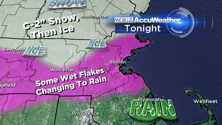
However, once the snow ends, there will be a risk for another type of wintry weather, freezing rain. Areas of light to moderate freezing rain should persist from late evening into tomorrow morning, particularly the Route 2 corridor, Merrimack Valley, Berkshires, etc. This is where temps will have a tough time moving much from near 32º well into tomorrow morning. It's not enough to create widespread power outages or bring down limbs, but is enough to make things slick.
Another issue to consider tonight will be the fog, which should start to become dense after midnight. The combo of high humidity and milder air flowing in over our deep snowpack should bring visibility down to <1/4 mile at times in spots. So extra caution all around re: travel tonight!
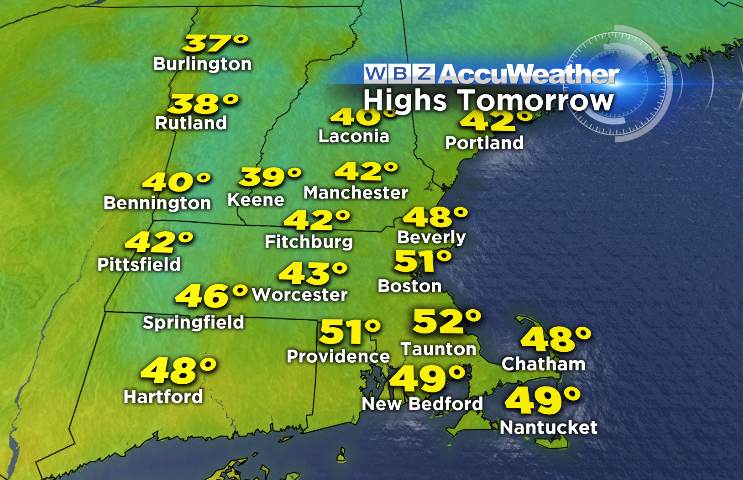
Tomorrow the warm front will make more northward progress once the sun rises, eventually getting up into NH and VT. Even still, it'll be tough to scour out the cold in interior MA. Winds look more easterly than anything else for much of the morning, keeping you in the 30s to low 40s. For Boston and points south, a push of southerly winds will eventually kick in and bring temps into the upper 40s/low 50s during the afternoon. So mild for some, but staying on the 'cool' side across the interior.
The one other aspect to this one will be an afternoon cold front, which should have a line of downpours along it. Instability looks plenty high enough to brings some lightning flashes and rumbles of thunder along with this line, with the timing looking like approx 4p-9p. There will be areas of mist, drizzle, and a few showers before this front...but most of the actual rain from this system will come along the front itself. Not expecting more than 0.75" anywhere in the area, but any rain will just soak right into our snow cover and add additional weight to roof tops, etc. Another reason to clear them off!
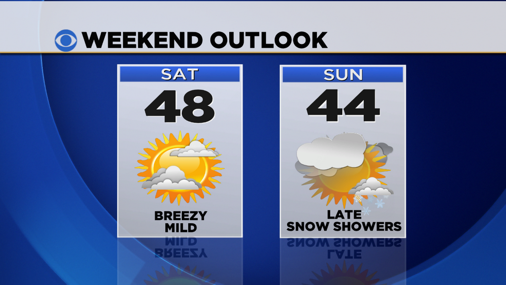
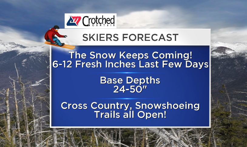
Our weekend looks excellent as the air behind this front isn't Arctic in origin. Highs in the 40s to near 50 on Saturday, 40s on Sunday. We'll take it. A broad cyclonic flow around a Hudson Bay low will try to bring a couple of impulses through - one on Saturday evening (few snow showers possible) and again on Sunday evening. But nothing major to interrupt travel, and a phenomenal weekend to hit the slopes or cross-country trails.
Next week, as we've been hinting at for a while now, looks like nothing but cold. Temps well below average from Monday all the way through next weekend. Lovely. So some extra incentive to enjoy the weekend. Highs will generally stay in the 20s everyday with single digits and teens at night. In terms of storminess, we're watching a wave which may bring a shot of snow Sunday night into Monday, and another storm which may try to come up along the coast on Wednesday. Both are low confidence events for now so stay tuned for updates as we get a little closer.
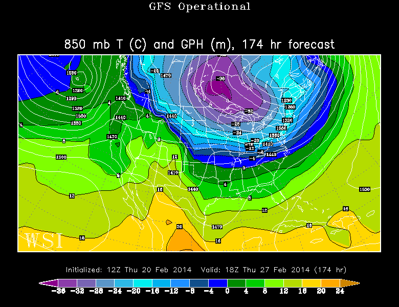
GFS 850mb temps for next Thursday. Huge area of bitter cold, especially the Upper Midwest to the Northeast. Source: WSI EnergyCast